In this section, you will become familiar with a widely used application of the UAS: the UAS for disaster response.
One of the widely utilized applications for the UAS is for disaster response situations. UAS is particularly useful for tasks that include one or all the 3 Ds -- dirty, dangerous, and dull:
Dirty: is much open to interpretation and to operation environment, but it can be described by flying over oil, nuclear, or gas installation sites where accidents have occurred, such as the Japanese Fukushima Daiichi nuclear plant, to take air samples or imagery.
Dangerous: refers clearly to situations where a pilot in a similar mission could become a casualty due to dangerous operations.
Dull: is when repetitive tasks are required over and over again. An example of the dull mission is border surveillance and maritime patrols that need eyes in the sky for hours at a time.
For UAS to suitably serve disasters, it needs more capabilities besides its adaptation for the 3 D’s factors. Such capabilities are defined by survivability, durability, and adaptability.
Survivability: Survivability of a UAS in a disaster response scenario relies on its efficient system of communications. For a UAS search and rescue mission, the UAS should consider three forms of communications. Those are:
- communication between the UAS operator and the UAS;
- communication between the operator and the victims on the ground;
- communication between other rescue ground machines and their teams.
Durability: The system's ability to survive a harsh or unpredictable operation environment such as unpredictable dropping debris, changing environment and loss of signal. UAS operation designers in such environments usually relay on multi-level UASs. As an example of this is the utilization of a High Altitude Long Endurance (HALE) UAS in the operation to carry equipment, provide a backup communication link, and to provide a high altitude overview of the site to plan emergency exits routes.
Adaptability: The ability of a mini-UAS with its small size to overcome fallen debris and unpredictable narrow spaces while maintaining its ability in sensing changes in an unpredictable and uncertain environment.
As examples of the use of UAS for disaster response, we will single out the UAS use for forest fire disasters.
UAS for Forest Fires:
Remote sensing techniques have proven to be very effective in mapping and monitoring fires and in giving feedback to first responders. Satellite remote sensing has limited capabilities in supporting fire response. This is due to the fact that the most available satellites have limited spatial resolutions (limited details) and they only occasionally orbit over the fire site, while fire monitoring needs continuous (24/7) coverage. However, satellite imagery can be useful in monitoring fires on a regional or national level, but not on a fire-front micro level. Thermal imagery from MODIS sensors on board the Terra and Aqua satellites with a resolution of 1 km were used by the U.S. Department of agriculture Forest Service Active Fire Mapping Program to monitor regional fires across the U.S. Beside the coarse resolution of its imagery, MODIS orbit any location only twice daily, which is infrequent for tracking the evolution of the fire and to support firefighters in real time.
Alternative to satellite imagery, aerial imagery from manned and unmanned aircraft is frequently used to provide needed frequent aerial observations of a fire. Two approaches were utilized in using the UAS for fire monitoring. The first High Altitude Long Endurance system (HALE) UAS can fly high and provide imagery with better resolution and better frequency than satellites. However, HALE UAS is expensive to procure and to maintain.
The second approach uses fleets of small UAS working cooperatively to provide more detailed information on the fire and its perimeter. In some cases, both approaches are utilized together with the HALE providing an overview image of the fire while small UASs are used to transmit high definition imagery in real time for the perimeter areas of the fire.
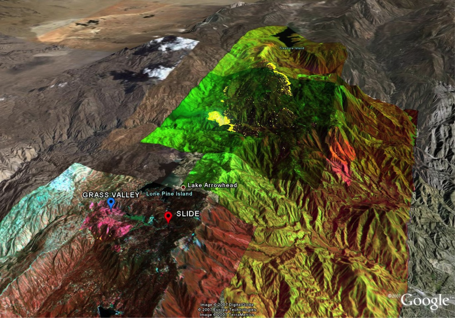
Here in the U.S., several wildfire monitoring programs have been adopted over the years. An example of such programs is the joint cooperation between NASA, General Atomics Aeronautical Systems, Inc. and various government agencies involved in fire research. The project used the General Atomics ALTUS II UAS, which is the civilian version of the Predator. Among the sensors on board the ULTUS II payload was a thermal multispectral scanner. Imagery was transmitted to the ground station through INMARSAT geostationary satellites. Once the imagery is received at the ground station, it goes through the geo-referencing and ortho-rectification processes, which convert them to a geo-referenced map before it goes into the hands of the field team. NASA published images (Figure 8.3) of the Grass Valley/Slide fire near Lake Arrowhead/Running Springs in the San Bernardino Mountains of Southern California acquired by the thermal-infrared imaging sensors on board NASA's Ikhana unmanned research aircraft. For more information on past NASA collaborative efforts in the field of different applications for UAS, visit UAS Integration in the NAS.