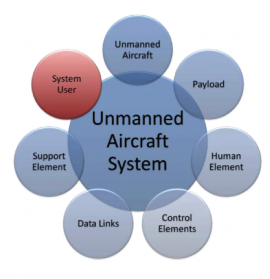
Welcome to Lesson 2! In this lesson, you will become familiar with the elements that combine to create an operational Unmanned Aerial System (UAS). Most UASs consist of an Unmanned Aerial Vehicle (UAV), human elements, payload, control elements (for a larger system it will be a ground control station (GCS) or mission planning and control station (MPCS)), and a data link communication unit (Figure 2.1). Military versions of the UAS will have an additional weapon system platform and supporting soldiers as part of the human element.
In addition, you will understand and develop knowledge about the different acquisition and auxiliary aerial sensors that are usually carried on board the UAS payload. Finally, at the end of this lesson, you will have a working knowledge of the different components forming a UAS and how the different components relate and interact with one another, the data acquisition sensors, and the auxiliary sensors that accompany a UAS mission, such as GPS and IMU.
Lesson Objectives
At the successful completion of this lesson, you should be able to:
- describe and identify the different elements of an Unmanned Aerial System (UAS);
- understand the functionality of each element making the UAS;
- explain how the different elements of a UAS complement each other;
- understand the basics in regard to an aerial vehicle design;
- describe different payloads;
- identify the different miniaturized sensors used for remote sensing;
- understand the fundamentals of digital cameras and LiDAR;
- understand the basics principals of GPS and IMU.
Lesson Readings
- Sections 3.1, 3.2, 3.3, 3.4, 3.5, and 3.6 of chapter 3 of textbook 1: Bankhart et al., Introduction to the Unmanned Aircraft Systems
- Chapter II from Crouch, C. thesis, “Integration of mini-UAVS at the tactical operations level: Implications of operations, implementation, and information sharing.”
- Section 2.6 of the report "Eyes of the Army, U.S. Army Roadmap for Unmanned Aircraft Systems 2010-2035."
- Chapter 13 of textbook 2: Fahlstrom, et al., Introduction to UAV Systems (Aerospace Series)
- Chapter 9 of textbook 2: Fahlstrom, et al., Introduction to UAV Systems (Aerospace Series)
- Chao, H. et al., "Towards Low-cost Cooperative Multispectral Remote Sensing Using Small Unmanned Aircraft Systems"
- Chapter 10, 11, and 12 of textbook 2: Fahlstrom, et al., Introduction to UAV Systems (Aerospace Series)
- Chapter 17 of textbook 2: Fahlstrom, et al., Introduction to UAV Systems (Aerospace Series)
- Williams, K., Human Factors Implications of Unmanned Aircraft Accidents: Flight-Control Problems, FAA report
- Takanmaki, I, et al., "How and why Unmanned Aircraft Vehicles can improve Real-time awareness?"
Lesson Activities
- Complete the Discussion Forum for Lesson 2: SWOT Analysis
- Take the Lesson 1 and 2 quizzes