2.1 Prerequisite: The Level of Detail
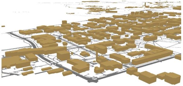
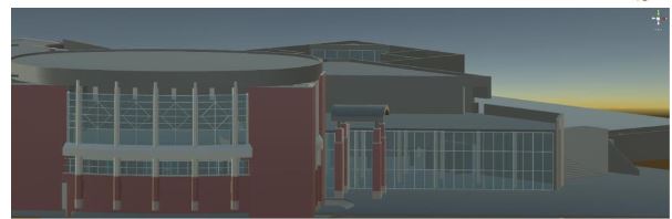
The Figure below shows different models of Penn State campus and Penn State buildings, respectively. It can easily be imagined that the level of detail of the model on the top may suffice for certain planning or analysis purposes, but that a detailed model (bottom) is required for applications such as architectural planning and engineering. The level of detail is not easy to define for 3D models and there is not a single standard for the "right" level of detail of 3D models. There are related discussions in cartography such as what is a schematic map (or are all maps schematic?). The level of detail is important though as it has implications on aspects such as performance, for example, in virtual reality environments. While there is not a direct correspondence between level of detail and polygon count (the number of individual surfaces that need to be processed), it can be easily imagined that complex models require a lot of computing power to interact with while, simple models allow for keeping up sufficient frame rates, for example, in immersive VR experiences (see Lesson 8 and 9). Interestingly, in many planning scenarios, people may decide to have more than one version of a model, one with a low and one with a higher level of detail in order to use them flexibly in different applications. Unlike map generalizations, there are only a few approaches that allow for 3D model generalization.
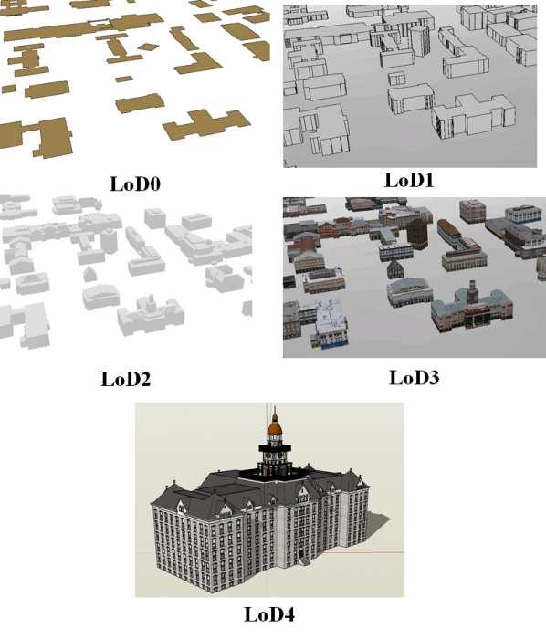
Below are examples of different levels of detail of 3D models.
It is advisable to think about the level of detail that one requires before starting the modeling process. It is still the case that the more detail you need, the higher the cost will be in terms of time, software product, and computing resources.
A good starting point for thinking of the levels of detail of 3D models is an approach referred to as CityGML that envisioned to standardize 3D models. While the active development of CityGML has slowed down, its classification of levels of detail provides a good basis for discussion. CityGML identifies five levels of detail based on accuracy and minimal dimensions of objects that can roughly be characterized as follows (see also Figure 2.1.2, and Kolbe et al. 2005):
- LoD0: essentially a digital terrain model with potentially 2.5D information.
- LoD1: the positional and height accuracy of points may be 5m or less, while all objects with a footprint of at least 6m by 6m have to be considered.
- LoD2: this level requires positional accuracy of 2m, while the height accuracy is 1m. In this LoD, all objects with a footprint of at least 4m by 4m have to be considered.
- LoD3: Both height and positional accuracy are 0.5m, and the minimal footprint is 2m by 2m.
- LoD4: Both height and positional accuracy are 0.2m.
As this brief discussion illustrates, the level of detail has substantial consequences on the visual appearance of 3D models, as well as on cost and efficiency. Cost is associated with time but also actual software products (e.g., high-end CAD programs for a higher level of detail; procedural rule software for a lower or medium level of detail). Efficiency is related to the computing power necessary to turn a 3D model into a smooth interactive experience.