Controlling Rivers
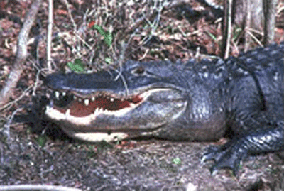
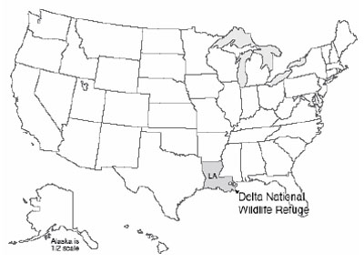
At the tip of the Mississippi Delta lies the Delta National Wildlife Refuge. This is one of several wildlife refuges along the Gulf Coast that, in addition to spawning a great range of resident wildlife, draw migrants from the north. Ducks and geese, herons and cranes, gallinules and rails, the wetland birds of most of a continent stream in through the fall, and then spread north again in the spring. (Yes, technically, a National Wildlife Refuge is not a National Park, but it is a national park, so we’ll cheat a little and use it—it makes a good story. And, it is just down the river from the wonderful bayous of the Barataria Reserve in the Jean Lafitte National Historical Park and Preserve—be sure to stop if you're in the area!)
Unfortunately, these wetlands are disappearing at an astonishing rate, because of the indirect effects of human activities. Estimates are that every year Louisiana is losing over 100 square kilometers of wetlands (equal to loss of a square with sides more than six miles long). Whether the wetland birds will continue to stream north for generations to come may depend on how humans respond to the challenge.
The Mississippi Delta is a massive pile of mud and sand from the Rockies and Appalachians, transported by the river and dumped into the Gulf of Mexico. The Gulf used to extend far into the heartland of what is now the U.S.; over the last 70 million years, the delta has grown southward from near Cairo, IL (up by St. Louis), until now the former embayment has been turned into a projection from the end of Louisiana into the Gulf. There, the delta is as much as seven miles thick. If you have ever watched mud settle in a bottle of water, or if you have observed how your boot packs mud down if you step in it, then you know that, over time, mud will compact under its own weight or under the weight of anything placed on it.
As the delta grew into the Gulf over the millennia, a natural balance was reached. The compaction that occurred during a year would leave a little space at the top, but the springtime floods would bring new mud to fill the space. Trees and other vegetation would grow up through the new sediment, or re-seed on top, and the system would continue, wildly productive and vibrantly green.
Wrestling with Mud
There is a problem with this system and humans, however. Many people have settled near the river. Plants can grow up through the mud of floods, but people don’t enjoy having their houses slowly fill up with mud. So, humans have built control structures. We built dams upriver, which trap sediment behind them and which hold some floodwaters in check. Because large floods threaten dams and must be let through, we also built levees along the river in its downstream reaches, great walls that hold the river in. We also dredge the river, deepening it to carry the water—and shipping. The great floods that shoot down the river then do not spread over the floodplain and the delta, depositing fertile sediment to fill the space left by compaction of mud, but instead are piped to the Gulf, where the sediment jets off the edge of the delta to settle in mile-deep water.
Way back in 1996, when the very first edition of this textbook was written, it read:
"Today, much of New Orleans, which does lie on the delta, is well below sea level. A tanker in the river between its levees is higher than the playing field of the Superdome. Rainfall, and water seeping from the river, must be pumped out so that the city doesn’t fill with water. If the pumps were to fail, the city would become a lake. The city steadily sinks deeper, and the levees are steadily raised by the Army Corps of Engineers, as instructed by Congress, to keep the river caged. Meanwhile, the wetlands of the delta, unnourished by new sediment, are sinking beneath the Gulf..."
After 2005, we know how terribly accurate the geological understanding of New Orleans really was. Where natural wetlands should have slowed the waves from Hurricane Katrina (which was not a really big storm by the time it got to New Orleans!), the high waters of the storm surge roared unimpeded from the Gulf. Parts of the levees failed. The pumps failed. The city filled with water, as much as 20 feet deep.
The hurricane showed what geologists (and emergency planners!) had long known, and had long told Congresspersons and Senators and students and others—New Orleans was a disaster waiting to happen, not “if” but “when.” With almost 2,000 people killed, hundreds of thousands of people displaced, and damages approaching $100 billion (that is, more than $300 from every single person in the United States), the danger of ignoring solid scientific evidence and hoping for the best is clearer than ever.
But, the city is rebuilt where it was, the sinking will continue, the loss of wetlands will continue unless many things are changed, and the levees will need to be raised. With the likelihood that the strongest storms will get stronger and sea level will rise in the future (we’ll revisit this later in the semester), the scene will be set for an even more horrific disaster at some future date. Many options are available, including restoring wetlands, filling parts of the city with debris or other materials, moving construction to higher parts of the city, moving out entirely, and more; it will be interesting to see how much of this will be done. But primarily, the donations and tax dollars from the rest of the country after the 2005 disaster were used to rebuild the city directly in harm’s way, with the knowledge that the rest of the country will once again foot the bill when disaster strikes.
Another story is being played out in this region as well. The river wants to leave New Orleans. The city has a love-hate relation with the river, fearing the floods but needing the drinking water and the shipping channel. The river can harm the city rapidly by flood, or slowly by leaving.
To understand this tendency of the river to leave New Orleans, note that especially large, muddy, flood-prone rivers normally have natural levees (which are much lower than the human-made ones). When a flood happens, the water spreads out of the main channel onto the flood plain, the flattish region of river-deposited muds next to the main channel. As the water spreads out into the trees or houses of the flood plain, the flow slows, and the water drops some of its muddy load. Just as the water leaves the main channel, the water is carrying the most load, and the slowing is most prominent, so most of the load is deposited right there next to the channel. Hence, the mud layer from a flood is thicker next to the river than farther away, forming a natural levee. Humans have raised these natural levees in many places.
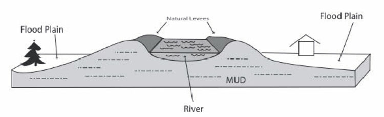
When we discussed reservoirs, we saw that the delta of sediment formed when a river enters a lake must build up as well as out, so that the river still flows downhill into the lake. The same is true for a river entering an ocean. The Mississippi River, with its levees, naturally dumps mud into the Gulf of Mexico, slowly lengthening and raising the river bed. After a while, the river is a bit like a log flume in an amusement park, following a long path to the Gulf; a break in the levee wall would allow a much steeper, shorter, and more exciting downhill trip. The recent history of the Mississippi Delta is that, roughly every 1,500 years, the main outlet of the river has broken through the natural levee, like a log full of park-goers breaking through a curve in the ride, and the river has then followed that new shortcut. But, as mud is deposited along that new shortcut, it lengthens until it is like a long log flume, and then the river breaks through a side again.
During the 1940s and 1950s, the Mississippi started to break out, into a side stream called the Atchafalaya River. To save the shipping channel and the water supply for New Orleans, the Army Corps of Engineers has used the Old River Control Structure and other dams and levees to allow some water to go down the Atchafalaya while keeping a vigorous flow in the main log-flume channel past New Orleans. During a flood in 1973, the Corps very nearly lost the Control Structure, and the river, when a giant whirlpool undercutting the dam came close to causing it to collapse. The task of the Corps is very difficult, taming immense natural forces as the system becomes more and more out of balance.
(An excellent account of this is given in John McPhee’s book The Control of Nature, 1989, Farrar, Straus and Giroux, New York, which may be a little out of date but is still fascinating, and shows that policy-makers and others were warned about the dangers in the area long before the disaster of the 2005 hurricane.)