So far in this chapter, I've tried to make sense of GIS in relation to several information technologies, including database management, computer-aided design, and mapping systems. At this point, I'd like to expand the discussion to consider GIS as one element in a much larger field of study called "Geographic Information Science and Technology" (GIS&T). As shown in the following illustration, GIS&T encompasses three subfields including:
- Geographic Information Science, the multidisciplinary research enterprise that addresses the nature of geographic information and the application of geospatial technologies to basic scientific questions;
- Geospatial Technology, the specialized set of information technologies that support acquisition, management, analysis, and visualization of geo-referenced data, including the Global Navigation Satellite System (GPS and others), satellite, airborne, and shipboard remote sensing systems; and GIS and image analysis software tools; and
- Applications of GIS&T, the increasingly diverse uses of geospatial technology in government, industry, and academia.This is the subfield in which most GIS professionals work.
Arrows in the diagram below (Figure 1.12.1) reflect relationships among the three subfields, as well as to numerous other fields, including Geography, Landscape Architecture, Computer Science, Statistics, Engineering, and many others. Each of these fields has influenced, and some have been influenced by, the development of GIS&T. It is important to note that these fields and subfields do not neatly correspond with professions like GIS analyst, photogrammetrist, or land surveyor. Rather, GIS&T is a nexus of overlapping professions that differ in backgrounds, disciplinary allegiances, and regulatory status.
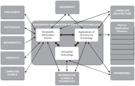
Related Disciplines to Geographic Information Science and Technology:
- Philosophy
- Psychology
- Mathematics
- Statistics
- Computer Science
- Geography
- Information Science & Technology
- Geospatial Technology
- Engineering
- Landscape Architecture
- Various Application Domains
The illustration in Figure 1.12.1, above, first appeared in the Geographic Information Science and Technology Body of Knowledge (DiBiase, DeMers, Johnson, Kemp, Luck, Plewe, and Wentz, 2006), published by the University Consortium for Geographic Information Science (UCGIS) and the Association of American Geographers (AAG) in 2006. The Body of Knowledge is a community-developed inventory of the knowledge and skills that define the GIS&T field. Like the bodies of knowledge developed in Computer Science and other fields, the GIS&T BoK represents the GIS&T knowledge domain as a hierarchical list of knowledge areas, units, topics, and educational objectives. The ten knowledge areas and 73 units that make up the first edition are shown in the table below. Twenty-six “core” units (those in which all graduates of a degree or certificate program should be able to demonstrate some level of mastery) are shown in bold type. Not shown are the 329 topics that make up the units, or the 1,660 education objectives by which topics are defined. These appear in the full text of the GIS&T BoK. The full text of the first edition can be found here: GIST Body of Knowledge PDF. An important related work produced by the U.S. Department of Labor is, however. We'll take a look at that shortly.
Knowledge Areas and Units Comprising the 1st Edition of the GIS&T BoK
- Knowledge Area AM. Analytical Methods
- Unit AM1 Academic and analytical origins
- Unit AM2 Query operations and query languages
- Unit AM3 Geometric measures
- Unit AM4 Basic analytical operations
- Unit AM5 Basic analytical methods
- Unit AM6 Analysis of surfaces
- Unit AM7 Spatial statistics
- Unit AM8 Geostatistics
- Unit AM9 Spatial regression and econometrics
- Unit AM10 Data mining
- Unit AM11 Network analysis
- Unit AM12 Optimization and location
- allocation modeling
- Knowledge Area CF. Conceptual Foundations
- Unit CF1 Philosophical foundations
- Unit CF2 Cognitive and social foundations
- Unit CF3 Domains of geographic information
- Unit CF4 Elements of geographic information
- Unit CF5 Relationships
- Unit CF6 Imperfections in geographic information
- Knowledge Area CV. Cartography and Visualization
- Unit CV1 History and trends
- Unit CV2 Data considerations
- Unit CV3 Principles of map design
- Unit CV4 Graphic representation techniques
- Unit CV5 Map production
- Unit CV6 Map use and evaluation
- Knowledge Area DA. Design Aspects
- Unit DA1 The scope of GI S&T system design
- Unit DA2 Project definition
- Unit DA3 Resource planning
- Unit DA4 Database design
- Unit DA5 Analysis design
- Unit DA6 Application design
- Unit DA7 System implementation
- Knowledge Area DM. Data Modeling
- Unit DM1 Basic storage and retrieval structures
- Unit DM2 Database management systems
- Unit DM3 Tessellation data models
- Unit DM4 Vector and object data models
- Unit DM5 Modeling 3D, temporal, and uncertain phenomena
- Knowledge Area DN. Data Manipulation
- Unit DN1 Representation transformation
- Unit DN2 Generalization and aggregation
- Unit DN3 Transaction management of geospatial data
- Knowledge Area GC. Geocomputation
- Unit GC1 Emergence of geocomputation
- Unit GC2 Computational aspects and neurocomputing
- Unit GC3 Cellular Automata (CA) models
- Unit GC4 Heuristics
- Unit GC5 Genetic algorithms (GA)
- Unit GC6 Agent-based models
- Unit GC7 Simulation modeling
- Unit GC8 Uncertainty
- Unit GC9 Fuzzy sets
- Knowledge Area GD. Geospatial Data
- Unit GD1 Earth geometry
- Unit GD2 Land partitioning systems
- Unit GD3 Georeferencing systems
- Unit GD4 Datums
- Unit GD5 Map projections
- Unit GD6 Data quality
- Unit GD7 Land surveying and GPS
- Unit GD8 Digitizing
- Unit GD9 Field data collection
- Unit GD10 Aerial imaging and photogrammetry
- Unit GD11 Satellite and shipboard remote sensing
- Unit GD12 Metadata, standards, and infrastructures
- Knowledge Area GS. GIS&T and Society
- Unit GS1 Legal aspects
- Unit GS2 Economic aspects
- Unit GS3 Use of geospatial information in the public sector
- Unit GS4 Geospatial information as property
- Unit GS5 Dissemination of geospatial information
- Unit GS6 Ethical aspects of geospatial information and technology
- Unit GS7 Critical GIS
- Knowledge Area OI. Organizational and Institutional Aspects
- Unit OI1 Origins of GI S&T
- Unit O2 Managing the GI system operations and infrastructure
- Unit OI3 Organizational structures and procedures
- Unit OI4 GI S&T workforce themes
- Unit OI5 Institutional and inter-institutional aspects
- Unit OI6 Coordinating organizations (national and international)
Ten knowledge areas and 73 units comprising the 1st edition of the GIS&T BoK. Core units are indicated with bold type. (©2006 Association of American Geographers and University Consortium for Geographic Information Science. Used by permission. All rights reserved.)
Notice that the knowledge area that includes the most core units is GD: Geospatial Data. This text focuses on the sources and distinctive characteristics of geographic data. This is one part of the knowledge base that most successful geospatial professionals possess. The Department of Labor's Geospatial Technology Competency Model (GTCM) highlights this and other essential elements of the geospatial knowledge base. We'll consider it next.