Geographic space is continuous. Although dual keys are not unique to geographic data, one property of the spatial key is. "What distinguishes spatial data is the fact that the spatial key is based on two continuous dimensions" (Goodchild, 1992, p.33). "Continuous" refers to the fact that there are no gaps in the Earth's surface. Canyons, crevasses, and even caverns notwithstanding, there is no position on or near the surface of the Earth that cannot be fixed within some sort of coordinate system grid. Nor is there any theoretical limit to how exactly a position can be specified. Given the precision of modern positioning technologies, the number of unique point positions that could be used to define a geographic entity is practically infinite. Because it's not possible to measure, let alone to store, manage, and process, an infinite amount of data, all geographic data is selective, generalized, approximate. Furthermore, the larger the territory covered by a geographic database, the more generalized the database tends to be.
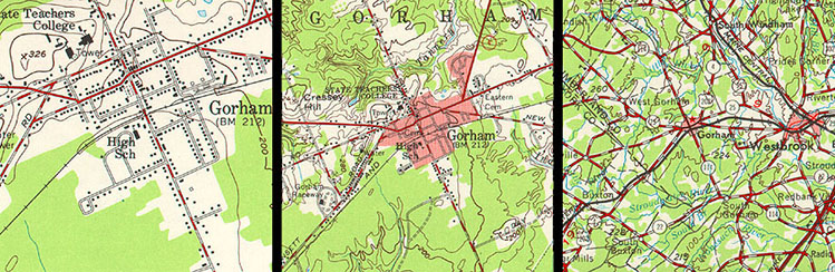
For example, the illustration in Figure 1.16.1, above, shows a town called Gorham depicted on three different topographic maps produced by the United States Geological Survey. Gorham occupies a smaller space on the small-scale (1:250,000) map than it does at 1:62,000 or at 1:24,000. But the relative size of the feature isn't the only thing that changes. Notice that the shape of the feature that represents the town changes also. As does the number of features and the amount of detail shown within the town boundary and in the surrounding area. The name for this characteristically parallel decline in map detail and map scale is generalization.
It is important to realize that generalization occurs not only on printed maps, but in digital databases as well. It is possible to represent phenomena with highly detailed features (whether they be made up of high-resolution raster grid cells or very many point locations) in a single scale-independent database. In practice, however, highly detailed databases are not only extremely expensive to create and maintain, but they also bog down information systems when used in analyses of large areas. For this reason, geographic databases are usually created at several scales, with different levels of detail captured for different intended uses.