"A body of knowledge" is one way to think about the GIS&T field. Another way is as an industry made up of agencies and firms that produce and consume goods and services, generate sales and (sometimes) profits, and employ people. In 2003, the U.S. Department of Labor identified "geospatial technology" as one of 14 "high growth" technology industries, along with biotech, nanotech, and others. However, the Department of Labor also observed that the geospatial technology industry was ill-defined, and poorly understood by the public.
Subsequent efforts by the Department of Labor and other organizations helped to clarify the industry's nature and scope. Following a series of "roundtable" discussions involving industry thought leaders, the Geospatial Information Technology Association (GITA) and the Association of American Geographers (AAG) submitted the following "consensus" definition to the Department of Labor in 2006:
The geospatial industry acquires, integrates, manages, analyzes, maps, distributes, and uses geographic, temporal, and spatial information and knowledge. The industry includes basic and applied research, technology development, education, and applications to address the planning, decision-making, and operational needs of people and organizations of all types.
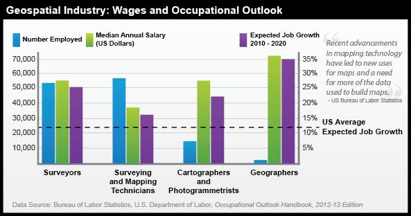
Currently, the Department of Labor recognizes 10 geospatial occupations: Surveyors, Surveying Technicians, Surveying and Mapping Technicians, Cartographers and Photogrammetrists, Geospatial Information Scientists and Technologists, Geographic Information Systems Technicians, Remote Sensing Scientists and Technologists, Remote Sensing Technicians, Precision Agriculture Technicians, and Geodetic Surveyors. Beyond these explicitly geospatial occupations, there are many others that rely heavily on geographical data and technology; these include urban and regional planning, many careers associated with location-based services, environmental management, landscape architecture and geo-design, transportation engineering, precision agriculture, and others. Still others use geographical data and technologies for selected tasks such as in public health (for infectious disease modeling and health care accessibility analysis), energy industries (to analyze distribution of oil and gas reserves or plan shipments), disaster management (to plan for and respond to events), and criminology (to identify crime hotspots and allocate patrols).
In addition to providing a wide array of occupational opportunities, the geospatial industry is considered a high growth industry. As of 2010, the US Employment and Training Administration is investing $260,000,000 through the WIRED (Workforce Innovation in Regional Economic Development) initiative to promote high-paying geospatial careers.
Although it is helpful to see how the Department of Labor and other agencies define the geospatial industry and how these occupations are expected to grow in the coming decade, many other careers and positions reliant on GIScience exist. Similar to how some geospatial technologies are well known while others operate behind the scenes, some careers in the geospatial industry might seem obvious to you, while others will be a surprise. Some of these careers and applications likely fall within a discipline or area you already find interesting.
Visit the links below to see examples of GIScience being used in fields you might not have considered.
If you like...Video Games and Entertainment,
EA Sports Uses NASA Topographic Data in SSX Game
Link: How NASA topography brought dose of reality to SSX snowboarding courses (ArsTechnica)
"He was like, 'Name any mountain on Earth,' and I was like, 'I don't know, Mount Everest.' So he goes on Wikipedia, gets the latitude and longitude coordinates... and in about 28 seconds, delivered a 3D model of Mount Everest and all the surrounding mountains in that grid from the data. He's like, 'If you give me a couple of days, we can take it for a ride...'"
If you like...Fisheries and Wildlife,
GIS and Remote Sensing are "Critical" to US Fish & Wildlife Service
Link: U.S. Fish & Wildlife Service: Information Resources and Technology Management | Critical Habitat Portal
“Geospatial services provide the technology to create, analyze, maintain, and distribute geospatial data and information. GIS, GPS and remote sensing play a vital role in all of the Service’s long-term goals and in analyzing and quantifying the USFWS Operational Plan Measures.”