In Lesson 7, you saw some ways that vector data can be drawn by the web browser or client. The lesson focused on standalone KML and GeoJSON files, yet it is also possible for a web service to send the data to the client on request. The data can be in any format as long as both the server and the client are following the same specification. To standardize the process of sending vector data through web services, the Open Geospatial Consortium (OGC) has produced the Web Feature Service (WFS) specification.
You've already seen a related service, the WMS, in previous lessons. How is WMS different from WFS? WMS involves the server sending a single map image, whereas WFS involves the server sending vector data as text to be drawn by the client. In simple terms, a WMS map is drawn by the server and a WFS map is drawn by the client.
WFS request and response formats
Like a WMS, a WFS supports a set of operations that typically take in parameters directly within the URL. These operations include GetCapabilities, DescribeFeatureType, and GetFeature. The GetFeature operation is the one that actually retrieves features.
Below is an example GetFeatures WFS request for the US state of Colorado (I picked something with a simple geometry). I adapted this from the Boundless WFS tutorial, which unfortunately doesn't seem to be available online anymore. Another recommended source for further information on WFS is the OGC e-Learning page. You won't be able to use the link below yourself, but see if you can guess what each parameter signifies, then continue reading about the response:
http://suite.opengeo.org/geoserver/wfs?service=wfs&version=1.1.0&request=GetFeature&typename=usa:states&featureid=states.23
By examining the above URL parameters, you can see that a feature is requested from the WFS using version 1.1.0 of the WFS specification. The service is being hosted on GeoServer in a layer named states in the USA workspace. The feature with index 23 is returned.
A WFS returns data using Geography Markup Language (GML), a specification for expressing GIS data using XML. GML can contain both geometry and attribute information. Because it is based on XML and is designed to be flexible enough to handle many geographic feature types, GML is much more verbose (takes more text) than GeoJSON. Deep down in the GML for Colorado, you can find the geometry:
<gml:posList>37.48468400000007 -109.04348799999995 38.164690000000064 -109.04176199999989 38.27548899999999 -109.06006199999996 41.0006590000001 -109.05007599999999 41.00235900000007 -102.051717 36.993015999999955 -102.04208899999992 36.99908400000004 -109.0452229999999 37.48468400000007 -109.04348799999995</gml:posList>
You can also find attributes like this:
<usa:NAME10>Colorado</usa:NAME10>
The same type of request could be made to one of your own services running on GeoServer. Here's how I made a request for a Philadelphia neighborhood using one of the layers we published earlier in this course:
http://localhost:8080/geoserver/wfs?service=wfs&version=1.1.0&request=GetFeature&typename=geog585:Neighborhoods&featureid=Neighborhoods.12
The response looks like this and contains geometry and attributes for the Olney neighborhood:
<wfs:FeatureCollection numberOfFeatures="1" timeStamp="2014-03-03T15:07:31.822Z" xsi:schemaLocation="http://localhost:8080/geoserver/geog585 http://localhost:8080/geoserver/wfs?service=WFS&version=1.1.0&request=DescribeFeatureType&typeName=geog585%3ANeighborhoods http://www.opengis.net/wfs http://localhost:8080/geoserver/schemas/wfs/1.1.0/wfs.xsd"><gml:featureMembers><geog585:Neighborhoods gml:id="Neighborhoods.12"><geog585:the_geom><gml:MultiSurface srsDimension="2" srsName="urn:x-ogc:def:crs:EPSG:3857"><gml:surfaceMember><gml:Polygon srsDimension="2"><gml:exterior><gml:LinearRing srsDimension="2"><gml:posList>-8363968.786751106 4869301.13520122 -8363706.077778376 4871057.31164155 -8363880.846283749 4871132.918517317 -8363697.377540309 4872031.511981935 -8363780.660729433 4872179.806916264 -8363847.448310932 4872208.890548547 -8363802.926044645 4872557.878939522 -8363802.44449278 4872626.491915396 -8363025.915000884 4872530.247301338 -8361543.138729884 4872310.6731403675 -8361453.88028348 4872223.294811407 -8361493.045963939 4872015.489274301 -8361627.94355705 4871826.7318475135 -8361690.687270048 4871673.398417745 -8361627.94355705 4871403.748827802 -8361286.901117077 4870791.777211798 -8361326.368936536 4870458.7113405885 -8361498.408149585 4869986.8871721085 -8361555.111808623 4869831.380121785 -8362695.297708079 4869623.850560427 -8363168.406381819 4869548.2551895585 -8363968.786751106 4869301.13520122</gml:posList></gml:LinearRing></gml:exterior></gml:Polygon></gml:surfaceMember></gml:MultiSurface></geog585:the_geom><geog585:STATE>PA</geog585:STATE><geog585:COUNTY>Philadelphia</geog585:COUNTY><geog585:CITY>Philadelphia</geog585:CITY><geog585:NAME>Olney</geog585:NAME><geog585:REGIONID>214146.0</geog585:REGIONID></geog585:Neighborhoods></gml:featureMembers></wfs:FeatureCollection>
WFS servers and clients
Although the syntax for WFS requests and responses may look intimidating, you will rarely have to worry about composing this yourself. Various FOSS and proprietary software packages include support for viewing and serving WFS.
WFS servers
As shown in the above examples, GeoServer can expose your layers through WFS. This is enabled by default and requires no configuration on your part. Other FOSS GIS servers such as Map Server and Deegree support the creation of WFS web services.
In the proprietary realm, Esri ArcGIS Server gives users the option to expose their web services through WFS; however, Esri has developed its own "feature service" that works through REST and accomplishes many of the same things as a WFS. Be aware that the Esri web mapping APIs and editing widgets are designed to work with the feature service rather than WFS. The communication patterns of the feature service are openly documented in the GeoServices REST Specification.
WFS clients
Support for WFS varies across web mapping APIs. WFS can be viewed "out of the box" as a vector layer in OpenLayers, but not within Leaflet. As mentioned above, Esri web mapping APIs are designed to work with the REST feature service rather than WFS.
Although Leaflet won't draw the GML responses sent by a WFS, it will draw GeoJSON; therefore, one pattern of working with WFS via Leaflet is to configure the server to send back GeoJSON instead of GML. You can then send WFS requests to the server via AJAX (asynchronous web requests) and use Leaflet classes to draw the geoJSON coming back. Such patterns are exposed through numerous forum posts, as well as third-party plugins.
On the desktop side, QGIS supports viewing and editing WFS. (Note: I got errors when trying to edit a WFS in QGIS, but I did not have a database or proxy host behind the layer.) Other FOSS clients such as uDig also recognize the WFS format. In Esri ArcMap, you use the Data Interoperability Extension to add WFS layers to the map (see "Connecting to a WFS Service"). ArcGIS Pro allows users to add WFS, and the extension does not appear to be required (documentation here).
Transactional WFS (WFS-T) and web-based editing
The WFS specification also defines rules for feature editing, opening the door to building clients that can edit geographic data over the web. A WFS enabled for editing is known as a transactional WFS, or WFS-T. Beyond the standard WFS operations such as GetFeature, WFS-T supports an additional operation called Transaction, and may also support operations for locking features to prevent concurrent edits.
Creating web editing applications requires both a server that can handle the incoming transactions and a client that provides visual support for the edit sketching, vertex manipulation, attribute entrance into text boxes, and so forth. The client sketching operations must be wired up to the WFS-T requests. Unless you're ready to write a lot of JavaScript, it's best to start with existing samples, widgets, or web controls. Leaflet offers a Draw control that can take care of the sketching part. See an example of what "Draw" can do. The respec/leaflet.wfs-t is an example of a plugin designed to wire up the Draw control to WFS-T requests. (Full disclosure: I have not tested this particular plugin, but there are other plugins based on the same concept).
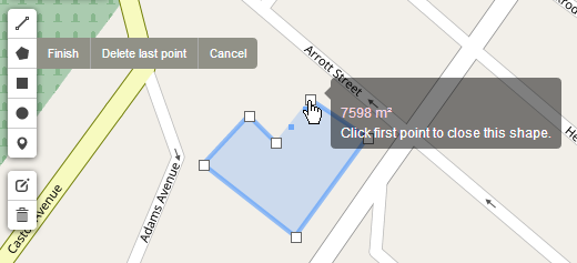
OpenLayers also offers some basic buttons for sketching, modifying, deleting, and saving features. You can see them in action in this developer example.
Before you expose any dataset for editing over the web, you should carefully think through your quality control and data storage architectures. For example, perhaps you want to expose a copy of your database for web editing, then have an analyst review any changes before they are pushed to your master GIS database. If in-house editors are making changes to the master database, you'll also need a way to periodically push those to your web copy. In other cases, you may check incoming edits with a script to make sure they comply with certain topology rules or attribute schema requirements.