Following are several analytic techniques that can be used to produce geospatial intelligence, considering the nature of intelligence and the grounding of the previously described theories.
Crime Mapping
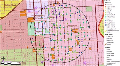
Crime mapping is the process of using a geographic information system to conduct spatial analysis of crime problems and other police-related issues. It facilitates visual and statistical analyses of crime, allows linkages based on common variables, and helps to communicate results of analysis. (Boba, R. 2022. Crime Analysis and Crime Mapping 5th edition. Thousand Oaks, CA: Sage.)
Police data includes: criminal incidents, arrests, calls for service, and traffic crashes and incidents. To see how an agency has incorporated crime mapping, go to the Philadelphia Police Department's Crime Maps and Stats site.
Geographic Distribution Analysis
Geographic distribution analysis examines the occurrence of events over a geographic area to determine what can be concluded about the activity. To complete a geographic distribution analysis, data on the locations of activities are collected and plotted on a map. Then, the information is reviewed to create a summary of what is depicted and from which to draw conclusions as to what the information means. (Peterson, M. B. 1994. Applications in Criminal Analysis. Westport, CT: Greenwood)
The following is an interactive website from Esri on crime mapping that allows you to analyze the geographic distribution of crime in the US versus various demographics. Crime Mapping.
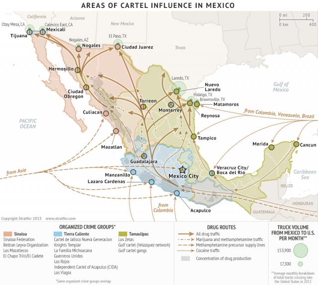
Geographic Flow Chart
The map below depicts a geographic flow chart that shows the movement of activities from one location to another. To complete this analysis, an analyst would summarize the information and draw conclusions about the activity to provide to a decision-maker.
Spatial Analysis
Spatial analysis explores relationships within and between data in space and provides the ability to define characteristics of the data as they relate to other information. (Steinberg, S. L. & Steinberg, S. J. 2015. GIS Research Methods. Redlands, CA: Esri Press) In the criminal justice field, spatial analysis creates a snapshot of crime incidents and related factors within a geographic area. Looking for patterns is one aspect of spatial analysis. Patterns can be found in locations, distances, direction, and hot spots. One application of spatial analysis in the fight against human trafficking can be found at A Global Display of Human Trafficking Incidents and News.
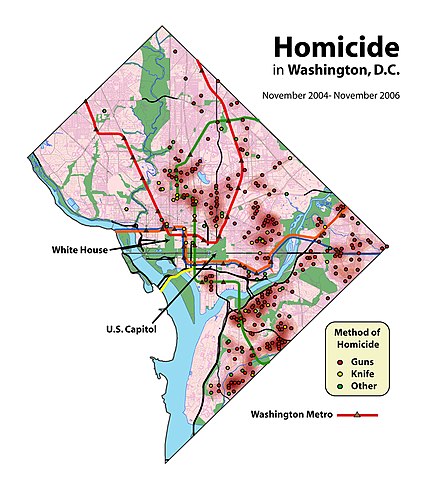
Public Domain Image:
Credit: Homicides in Washington, DC by User:Aude from Wikimedia (Public Domain).
Using Other Applications of GIS&T and GEOINT in Criminal Investigations and Law Enforcement
You can use GIS&T and GEOINT for other purposes as well. Some examples include:
- Looking up sex offenders to assist in child abduction cases using an application such as Family Watchdog.
- Tracking motor vehicle thefts using tools such as OnStar and Lojack.