Permafrost and Periglaciation
Meanwhile, what of things back in central Pennsylvania and in the many other places that were not quite reached by the ice-age ice? As you might imagine, with the world cold enough to grow ice to cover New York, Chicago, Minneapolis, and Seattle, as well as much of Europe, the climate was colder everywhere then than it has been more recently.
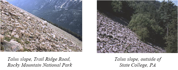
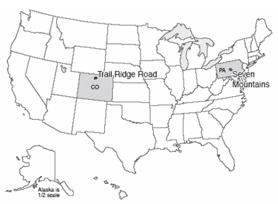
If you climb the ridges of central Pennsylvania, perhaps up in the Seven Mountains just southeast of State College (go up Bear Meadows Road past the ski area, for a start), you may notice several interesting things geologically. Beneath the hemlocks and rhododendron, the soils and streams and hillslopes have more in common with the high meadows of Trail Ridge Road in Rocky Mountain National Park, or with the coast of Greenland, than they do with the modern climate of State College. Trail Ridge Road crosses tundra, where small, hardy plants grow atop permafrost. Although the uppermost soil along Trail Ridge Road thaws during the brief summers, and the deep Earth is thawed by the heat of the Earth, the materials between are frozen year-round in permanent frost. (These areas are also called “periglacial,” because they may occur around the glacier, or on its perimeter.)
Consider the following features of the Seven Mountains.
- Many of the headwaters streams have the braided pattern that forms when lots of big rocks are supplied rapidly. Large rocks are evident across the beds of these braided streams. But, the sediment is not “active.” Trees grow on the bars. Even huge floods, such as the winter flood of 1996, do not move the rocks beneath them. Something in the past delivered much coarse sediment to the streams, and then that delivery stopped. Meanwhile, along Trail Ridge Road today, freeze-thaw processes in the tundra break loose large blocks of rock that can be moved to streams.
- The highest points on the ridges of the Seven Mountains are composed of resistant sandstone bedrock, but near the surface, the rock has been broken into huge blocks, of the sort that are worked loose by freeze-thaw activity. On flat places such as Big Flat, these blocks sometimes are patterned, with higher and lower, coarser and finer regions a few yards (or meters) across. (These features were described by geologists during times when logging and fire had removed the thick vegetation; the features are very hard to see and almost impossible to photograph today, but can be found during careful bush-whacking.) Meanwhile, similar features occur along Trail Ridge Road and in other permafrost regions, where expansion-contraction processes during the seasonal freezing and thawing of the upper layer sort and stir the rocks and soil into such patterns.
- Stripes or fields of sandstone blocks extend from the ridges down across other rock types to the streams. The blocks are often aligned, as they would be in a creeping soil mass. The coarsest blocks typically are on top with finer material beneath, and patterns such as those on Big Flat may be present but elongated as if they were creeping downhill. Yet the blocks are not now creeping downhill; trees grow on top, and have not been knocked over or bent by landsliding or soil creep. Meanwhile, when the top of permafrost melts on Trail Ridge Road or elsewhere, the water cannot drain out through the rocks beneath because the spaces between those rocks are plugged by ice. The water is trapped in the thawed layer, which then is capable of creeping on very gradual slopes. “Solifluction” or soil-flow lobes thus are common extending downhill.
- Bear Meadows is a young feature, probably formed during the coldest part of the most recent ice age, and probably dammed by a debris-flow or soil-flow lobe extending down from the ridge above it. Bear Meadows is one of the few natural wetlands of any size in central Pennsylvania. The meadows provide a favorite blueberry-picking spot for people—and bears—in the region. The plants of Bear Meadows are quite interesting and varied. Examination of a core pulled from the mud that fills the bog shows that the bottom is almost free of organic material—just silt. Above that, pollen and other remains of cold-weather plants appear, dating to the first bit of warming from the ice age, followed by a progression to warmer-weather types and on to the modern, productive bog. A nearly barren tundra of the Trail Ridge Road type, with a solifluction lobe that dammed a stream, followed by warming, would have produced the sediments we see.
- Other permafrost indicators can be found near State College, including some down in the valleys.
The conclusion is nearly inescapable—Trail Ridge Road in Rocky Mountain today is an excellent picture of what the Seven Mountains looked like during the ice age. Permafrost is common across much of northern Canada and Siberia and around the coast of Greenland, and in high-altitude regions. Permafrost poses grave problems for construction—the heat of a building can melt permafrost beneath, causing uneven settling that breaks the building. Permafrost also records the climate changes that have come to central Pennsylvania and other regions.
An Important Aside: Is This Story-Telling or Science? (Hint: Science...)
Perhaps more meaningful than the conclusion of past Pennsylvania permafrost is the underlying reasoning. Some people today, including important government officials, claim that “historical” geology is not really science, does not use the scientific method, does not produce scientific results, and so should be ignored. (Many commentators have noted that these government officials typically dislike policies that might be motivated by the science, and are probably really more interested in complaining about the policies than the research. But, let's look at the research.)
Consider how the process works. Go up to Bear Meadows, start up toward the ridge above, and look around carefully. You see that big rocks are present, of a type that is quite different from the bedrock directly beneath.
Many hypotheses are possible to explain this observation—space aliens dropped the big rocks; or bulldozers pushed the rocks into place; or, the rocks came screaming down from uphill in a giant landslide; or, they came creeping down slowly; or, … you could think of others. Each hypothesis leads to predictions. If a bulldozer pushed the big rocks in, we should find the bulldozer tracks, and we should be able to trace back in historical records to who was driving the bulldozer, and why. The first settlers, who arrived before bulldozers were invented, should have found hillslopes free of big rocks. If the big rocks came from uphill, we should be able to find a source of such rocks uphill. Landslides start with big falls or slumps from particular places, so a landslide should have a big scar at its head, whereas creep slowly collects rocks as they are worked loose and carries them along, lining them up as they go.
So, you look for evidence that supports or refutes each of your hypotheses. The early settlers complained about the big rocks, old cabins are built on the big rocks, so the bulldozer hypothesis won’t work. There is no evidence for a landslide scar anywhere, despite evidence for lots of different “stripes” of big rocks extending downhill from a ridgetop source where bedrock of the same type as the big rocks sticks out. You quickly come to the realization that the rocks look like a soil-creep deposit extending down the ridge crests; the predictions from each of your other hypotheses fail, but each of the predictions from the soil-creep hypothesis is supported by additional data that you collect for testing purposes.
Then, you note that the material is not now creeping—roads and trails are not being slowly buried by big rocks today, the trees are not knocked over, etc. Tree roots hold many of the rocks in place and prevent motion. So you look for a time in the past when tree roots were not holding the rocks in place. You collect more information—the big rocks are on top of smaller rocks and soil, not on the bottom, the big rocks are often standing on edge, the rocks show patterning of coarse and fine, etc. Other geologists are scanning the whole planet, laboring over centuries, and among the many things these geologists report are the conditions of creeping hillslopes in the tropics, the deserts, the temperate zones, and the poles. You talk to other geologists, devote a decade of your life to careful study, and eventually learn that the things you see on the slopes of the Seven Mountains resemble features of permafrost, and not features of any other modern setting.
But, if you are correct and these are permafrost features, there should be other evidence of cold conditions in the past, at the time that these features were active. So you take a core in the bog, and find that the bog started in a very cold time (the deepest pollen you find is from plants that today are found only on the tundra), and the bog seems to be dammed by one of the soil-flow lobes, linking the soil-flow lobes to the time of the tundra cold. (It is true that no one has used a backhoe to take the dam apart to look for a space-alien-constructed dilithium-crystal foundation, so maybe the space-alien hypothesis has not been completely falsified and the science could be improved; but, there comes a point of diminishing returns….)
Next, you ask whether this makes sense. You have tentatively concluded that the hillslopes of Pennsylvania record cold conditions at a particular time in the past. Is there a reason why cold should have been here at that time? Well, just to the north, glaciers were pushing up moraines at the same time. And astronomers making orbital calculations find that the high northern latitudes were receiving about 10% less sunshine than today during that glacial age. Climate modelers who test whether such a drop in sunshine would be sufficient to grow glaciers and make conditions very cold find that cold indeed makes sense, especially when the modelers include the effects of the drop in atmospheric CO2 levels that was triggered by the change in sunshine and that is recorded in ice-core bubbles from the time.
Now, a modern geologist who tells the “story” of this chapter—Pennsylvania hikers twist their ankles on permafrost deposits—actually has a lot more evidence than the little sketch provided here. The libraries of information collected by centuries of Earth scientists are woven together in a sophisticated, carefully tested, highly reliable whole. This great tapestry of knowledge still has gaps, dropped stitches and moth-bitten places, and the ragged edge where knowledge runs out into the unknown that so excites us as scientists. But the science of the tapestry is well-woven and exceptionally strong. We can only hope that the misguided attacks on this science come from ignorance and not malice, because ignorance is more easily changed.