Glaciers and Glacier National Park
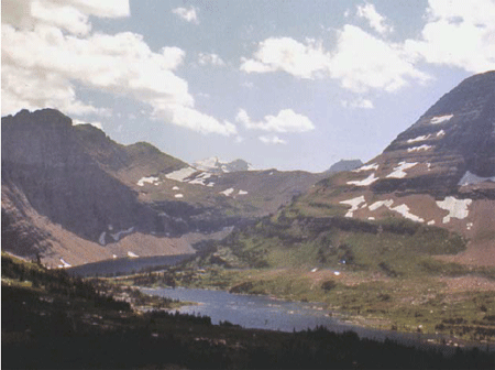
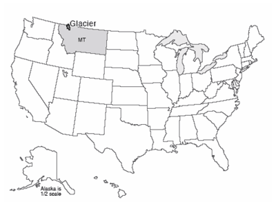
Glacier National Park is the southern half of the Glacier-Waterton Lakes International Peace Park, extending north-south across the Canadian-U.S. border and east-west across the great Front Range of the Rockies. Glacier is wolves and grizzly bears, mountain goats balanced on cliffs, moose munching on water plants, beargrass and avalanche lilies. Going-to-the-Sun Road winds past Going-to-the-Sun Mountain, among the best-named features of the park system. The continental divide snakes along the Garden Wall, in many places a knife-edge ridge left as glaciers gnawed into the backbone of the continent from the east and the west. Long, narrow lakes lie along the valleys, which sometimes host lines of lakes strung like beads on the string of the connecting river. (Such glacier-carved strings of lakes are called paternoster lakes, after a resemblance to the beads of a Catholic rosary.
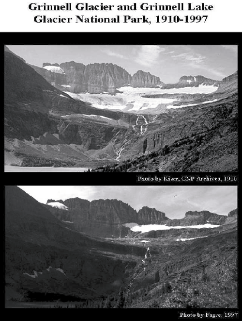
Glacier National Park had roughly 150 active glaciers a century ago, but that is down to 25 or so very small ones, and many of them may be essentially dead now, as modern warmth melts many away (see the changes shown by the older and more-recent photos below). Glacier National Park thus is now more noted for the tracks of past glaciers than for the activity of present ones. But, we suspect that “Ex-Glacier National Park” would not have made the Great Northern Railway happy when they were promoting tourism in Glacier National Park (via the Great Northern Railway, of course). When the last glacier has melted away, perhaps within a few decades (we'll return to this with the Arctic National Wildlife Refuge, near the end of the course), there are no plans to change the name of the park.
Evidence of Ice Ages
Today, permanent ice covers about one-tenth of the land on Earth, mostly in Antarctica and Greenland, with a little ice in mountainous regions. We saw at Yosemite that glacier erosion and deposition produce features that differ from those produced by mass movement, rivers, wind or coasts. Geologically recent examples of those features, from roughly 20,000 years ago, are spread across almost one-third of the modern land surface—in places such as Wisconsin, and northern Pennsylvania, and Yosemite, and Glacier, and many others, the mark of the ice is unmistakable. The 10,000 lakes of Minnesota, the Great Lakes, the gentle moraines of Illinois, and many more features reveal a landscape that is glacially dominated. Such features in Europe first motivated the hypothesis that ice ages have occurred.
This ice-age hypothesis makes many predictions, which allow testing. In times before modern geology, the glacial deposits were called “drift” because they were thought to have drifted into place in icebergs during Noah’s flood. Other people have suggested that the deposits were splashed into position by a giant meteorite that hit Hudson Bay, and still other hypotheses have been advanced. But, the ice-age hypothesis makes predictions that differ from the Noah’s-flood hypothesis or the meteorite hypothesis in many ways. (The biggest difference is that icebergs and meteorites simply do not make features that even vaguely resemble those actually observed, but let’s look at some other differences.)
If huge ice really existed, its great weight must have pushed down the land beneath—recall that the deep rocks are hot and soft, with a “water-bed” cover of stiffer rocks on top. If the ice age peaked only about 20,000 years ago, the slow flow of the soft, deep rocks should mean that the land would still be rising after the melting of the ice, while land around the former ice would be sinking as the soft, deep rocks return to their pre-ice-age positions. The global-flood hypothesis and the meteorite hypothesis do not predict such a bulls-eye pattern of rising and sinking centered on the regions with features known to be made by glaciers today—the flood would have spread evenly across the land, and so would not have concentrated its weight in one place, and the sudden blast of the meteorite would not have left its weight long enough to push the slow-flowing deep rocks far. Measurements by GPS and other techniques show just the pattern expected from the ice-age hypothesis, a pattern that was not predicted and cannot be explained by the other hypotheses.
The water for huge ice sheets would have been supplied by evaporation from the oceans, with the water getting stuck in the ice rather than returning rapidly to the sea in streams. Hence, if ice ages occurred recently, there should be evidence of lower sea levels at the time the ice was big. No such prediction comes from the meteorite or big-flood hypotheses (the meteorite might have made a wave but otherwise would not have affected sea level; the big flood would have raised sea level). Again, the ice-age prediction is borne out by the evidence, and the predictions of the other hypotheses are wrong. For example, some corals grow only in shallow waters where there is much sunlight. Dead samples of such corals from about 20,000 years ago can be found where they grew, down the sides of islands and now under more than 300 feet of ocean water. Other evidence also points to lower sea level in the recent past—the Chesapeake Bay, for example, is a river valley that was drowned by rising waters.
How Many Ice Ages?—An Ocean of Clues
So, much evidence shows that ice ages occurred. Piled tills separated by soils demonstrate that the ice has come and gone many times. But how many times? On land, the glacial record is somewhat confused—often, an advancing glacier will erode the evidence of a previous one. A pile of four tills separated by soils may record four advances, or forty, with some of the record having been eroded away. In many places in the deep oceans, sediment has been piling up without erosion for millions of years. If there were a marker of glaciation in the marine sediments, we could tell how many glaciations have occurred. If there were a way to date these sediments, we could tell when the glaciation happened. Fortunately, we can identify glaciations using shells in marine sediments, and we can date them. Identifying glaciers from shells is covered here, and learning the age of the shells is coming in the next few units.
Water in the oceans is not all the same—roughly one molecule in 500 has an extra neutron or two in one or more of the oxygen or hydrogen atoms. Such “heavy” water is still water, but weighs a little extra. (If you don’t remember isotopes, go back and have a quick look at the introduction to chemistry near the start of the course.) Not surprisingly, light molecules evaporate more easily than heavy molecules. Water vapor, rain, and snow thus are slightly “lighter” than the ocean; that is, the ratio of light water molecules to heavy ones is larger in vapor, rain, and snow than in the ocean from which the vapor, rain, and snow came.
When sea level drops during an ice age - as water vapor is changed to snow and then to ice sheets, the oceans have lost a lot of water. More light water than heavy water has been lost from the oceans, so the oceans are left a little bit isotopically heavier than normal. When ice melts, that light water from the ice sheets is returned to the ocean and makes it lighter.
These changes are very small. If we round off the numbers a little, we can say that in the modern ocean, 1 of each 500 water molecules is heavy, which is the same as saying that 1000 of each 500,000 water molecules are heavy. When the ice sheets were big, had you weighed a whole lot of molecules in the ocean, you would have found that about 1001 of each 500,000 water molecules were heavy. This is a tiny change, the water was still water, but sophisticated modern instruments are so good that such a change is very easy to measure. (And yes, the instruments actually measure the weight of waaaaaaay more than 500,000 molecules, to obtain good statistics.)
Many plants and animals that grow in the ocean build shells of calcium carbonate (the stuff of limestone) or of silica, both of which contain oxygen. These shells record the isotopic composition of the water in which they grow because the oxygen in the carbonate or silica is obtained from the water. Critters growing during big-ice times grow shells in which the oxygen is isotopically slightly heavy, and critters growing during small-ice times grow isotopically light shells. When the critters die, their shells pile up in layers on the sea floor with the youngest ones on top. A core collected from these sediments is a history of the ice volume on Earth. Just date the core, pull out the shells, analyze them isotopically, and there is the answer. With enough care, knowledge, and instrumentation, dedicated workers can obtain consistent, reproducible data that tell a wonderful, clear story. (There are a few additional details, but the main story is this simple.)
Over the most recent 800,000 years, ice has generally grown for about 90,000 years, shrunk for 10,000 years, grown for 90,000 years, shrunk for 10,000 years, etc. Superimposed on this are smaller wiggles, with a spacing of about 19,000 years and 41,000 years.
The Cold of Space
More remarkable, these cycles were predicted, and not until decades after the prediction did technology become good enough to test the prediction and show that it worked. During the 1920s and 1930s, a Serbian mathematician named Milutin Milankovitch calculated how the sunshine received at different places and seasons on the Earth has changed over long times. As the sun, moon, Jupiter and other planets tug on the Earth, the orbit changes a bit. Earth wobbles with a 19,000-year periodicity, the north pole tilts a little more and then a little less with a 41,000-year periodicity, and the orbit changes from more-nearly round to more squashed or elliptical and back with a 100,000-year periodicity. With modern computers, these changes are relatively easy to calculate for many millions of years; for Milankovitch, the calculation was the labor of a lifetime. (He did it very well, though, even correctly noting that the 19,000-year periodicity really goes from 19,000 to 23,000 years and back, a pattern that is indeed observed in the data testing his prediction!)
These orbital wiggles have little effect on the total sunshine received by the planet, but they do move the sunshine from north to south, poles to equator, or summer to winter in various ways. For example, today the northern hemisphere is farther from the sun in northern summer than in northern winter. (Remember that summer is controlled by the tilt of the planet’s spin axis relative to the plane in which the planet orbits, not by the distance from the sun!) In the few millennia centered on 9000 years ago, the northern hemisphere had slightly warmer summers and cooler winters than recently, because the Earth was closer to the sun during northern summers and farther from the sun during northern winters than today. (Meanwhile, the south had slightly cooler summers and warmer winters than recently, because the Earth was closer to the sun during southern winters and farther from the sun during southern summers than today.) The intense summer sunshine in the north 9000 years ago made mountain glaciers smaller then. As the summer sunshine decreased in the north, those glaciers expanded slowly for several thousand years, culminating in the Little Ice Age of the 1600s to 1800s; strong melting of glaciers since then is probably mostly the result of human-caused warming. (We will discuss this later in the course.)
Summer in the northern hemisphere appears to be key to controlling ice ages, probably because the northern hemisphere is mostly land and can grow big ice sheets, but the southern hemisphere is mostly water, already has ice on Antarctica, and so can’t change its land ice much more. In the north, even during warm winters the highlands around Hudson Bay are cold enough to have snow rather than rain. Survival of this snow requires cool, short summers. As summers have cooled around Hudson Bay, ice has grown; as summers have warmed, ice has melted. The way the various cycles interacted led to larger or smaller changes, and thus to the ice ages we know.
You may guess that this is slightly oversimplified so far. For example, during times when Canada has received reduced summer sunshine, allowing ice to grow, the southern hemisphere or the tropics often were receiving extra sunshine, yet they cooled during many of those times. How Canada told the glaciers of Patagonia and Antarctica to grow was for a long time a great puzzle. The answer involves the global warming from atmospheric carbon dioxide. The growth and shrinkage of the vast ice sheets, the changes in sea level, and other changes had the effect of shifting some carbon dioxide (CO2) from the air into the deep ocean during ice ages, and bringing the CO2 back out to the air during warm times. The orbits affected the ice, which affected currents and sea level and plants and other things, which affected CO2. But, as we will discuss later in the semester, CO2 in the air tends to warm the Earth's surface no matter how that CO2 got into the air. And, the changing CO2 explains why, when the ice was growing, places getting more sunshine still got colder, and why, when the ice was shrinking, places getting less sun still got warmer.
Climate records show many other types of changes. Very large, rapid changes have been caused by sudden surges of ice sheets, and by jumps in the way the ocean circulates. We do not understand these faster changes well enough to know whether they could happen again, although we're cautiously optimistic that we won't have any for a while. Naturally, the Earth’s orbit right now is in an intermediate state, and we should be looking forward to another 20,000 years or more with little change before we begin the slide into a new ice age. (See the Enrichment for a little more on this.) However, humans almost certainly are now more important to the climate than are such slow changes, as we will see later.