There are two Unit 4 GeoMations (animations) and three GeoClips (movies) linked below. We hope they help you understand and enjoy Unit 4.
GeoMations:
The Rockies
We've been looking at how spreading ridges under the ocean make seafloor, which moves away from them and eventually gets old and cold and sinks down. And it will be sinking down beneath a continent, often, and it will scrape things off to make the Olympic. And then it will have a big volcanic range such as the Cascades, Mount Saint Helen's, and so on.
And they will be sitting there next to the ocean, which we can draw in. And coming up from below, there will be melt to make seafloor out here. And coming up from below there will be materials that erupt at the volcanoes like that.
Now, that works all fine, but what happens when there is a little bit of a swinging down of the slab? We know that the slab is moving away from the seafloor spreading ridge, as I show here. But the slab really does have a little of this swinging down, as well, in some cases. And the continent moves to catch up with it.
And so pretty soon, the continent is going to end up getting close to the spreading ridge. And the stuff going down is then not going to be cold. It's going to be getting warmer.
And when that happens, we have to erase this, because now the materials don't want to go down anymore. You'll get something that goes more like this, with it running right underneath the edge of the continent and staying high. And where it runs under the continent and stays high, you'll get a lot of rumpling, a lot of pushing happening in this way. And so then you might expect to see something that gets pushed up like this. And we're reasonably confident that that sort of push up is what the Rockies are.
In a few cases, as in the west, where the San Andreas Fault is, in fact, the subduction zone has been pushed all the way out and has run over the spreading ridge. And the subduction zone and the spreading ridge annihilated each other. And then you've got the San Andreas Fault.
Icebergs
Out in the ocean, there's a giant iceberg sitting out here. Big thing threatening the oil platforms floating around. And in the bottom of this very special iceberg, there is a really strange looking, googly-eyed space alien. And you have been given the task to go out there in your little boat sitting here in the water to get the space alien out.
Now, you're a good geosciences 10 student, and you know that all icebergs have about 1/10 above the surface, and they have about 9/10 below the surface. So you know immediately what to do. You take your gimongous chainsaw and you chainsaw off the top of the iceberg and throw it away, because you know what this will cause is that the iceberg will come bobbing up, carrying the space alien with it.
And so after it gets done bouncing up and down for a little bit, you find that the iceberg is almost as tall as it was before. It still has, sitting way down in the bottom of it, the space alien that you're trying to get to. So there's a space alien down here. And it still has about 1/10 of its height above the surface, and about 9/10 of its height below the surface.
But what you find is it's just a little bit shorter than it was, and it doesn't stick down quite as far as it did. Now you wump the top off again, and you keep wumping the top off, and you keep wumping the top off. And after a long time, you get down to a little iceberg that doesn't stick very far down.
Now it still is the same picture, that it has 1/10 above, and it has 9/10 below. And if you're not careful, you're sitting there admiring this lovely fact of science, and the space alien sticks out a giant tentacle, and it grabs your ship and throws it to the bottom of the sea. And so you'd better not do that.
However, there is a scientific piece to this. Suppose instead of space aliens, that we wanted to talk about mountain ranges. Now, we know that mountain ranges stick up above the plains. But you might not have known that they also stick down.
They have a root in the same way that an iceberg has a root that it's sitting on. There's a slight difference in that about 1/7 of a mountain range is up and about 6/7 of a mountain range is down, way down. The rocks have been heated. They've been squeezed. There's all sorts of interesting things going on and new minerals being grown.
And at the surface, the streams are sitting here, busily trying to grind away the mountain range. As the streams grind away the mountain range, why, the deep stuff will come bobbing up towards the surface. And if you come much later and look at it, you'll find that the rocks have barely any mountains left.
There's still a little bit of root with 1/7 up and 6/7 down. But now what you'll find is that the rocks that had been cooked way down, and bent way down, are very near the surface. And you can go see them.
GeoClips
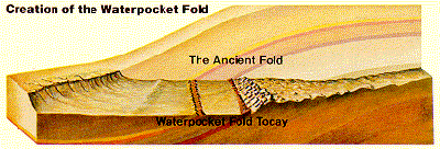
In the text, you read about changes in subduction as North America neared and overran the spreading ridge in the Pacific, with the increasingly warm downgoing slab rubbing along the bottom of the continental lithosphere and squeezing and wrinkling the rocks far inland. The Front Range of the Rockies is the most dramatic evidence of the "wrinkling" from that squeezing, but many other ranges and smaller features have the same origin. All sorts of different shapes of folds and wrinkles are observed. One spectacular one, which few relatively few people visit, is the Waterpocket Fold in Capitol Reef National Park. The diagram here, from the Capitol Reef website of the National Park Service, shows the fold (of a type called a monocline, although you don't have to worry about memorizing fold types) both before and after erosion along the lovely Fremont River. You will see more of the fold with Kym Kline and Dave Janesko in the short video. (Note that the Park Service diagram and Dave-and-Kym’s demonstration are of the same thing, but viewed from opposite sides, so that Dave-and-Kym’s fold slopes down to your right and the Park Service’s slopes down to your left.)
CAUSE 2004 - Capitol Reef Monocline
[MUSIC PLAYING]
We're at Capitol Reef National Park, home of the famous Waterpocket Fold. In the background, we can see it. We can see the layers dipping this way from the west, and you can't really see the layers on that side. This is a classic monocline, and it's a 100-mile long flexure in the Earth's crust. And Dave going to help show us how it formed.
This is the Earth's crust. And then 50 to 70 million years ago compressional stress came from the west and caused a bulge. And rocks on the west side were lifted up on along a thrust fault about 7,000 feet higher than rocks on the east side. Later, uplift during the uplift of the Colorado Plateau about 15 to 20 million years ago left it susceptible to erosion and the top part was eroded off. and you got many of the geological features you'll find in the park, like monoliths, and canyons, and arches.
The reason the Waterpocket Fold got it's name is when the younger layers up here were eroded, softer layers beneath were exposed and formed small basins in which water gathered in, which provided a water source for early settlers.
[MUSIC PLAYING]
Metamorphic rocks—those cooked and squeezed deep inside a mountain range—are often especially pretty. At the bottom of the Grand Canyon, you can see such rocks. They were formed long ago and many miles down, and then reached the surface as erosion removed the mountains above and the deep roots of those mountains floated upward. Later, these rocks were buried again under sediments from oceans, rivers and wind, and finally revealed to us as the Grand Canyon was carved by the Colorado River. Some people—including Dr. Alley—think that these rocks are so beautiful that they're worth the overnight hike into the canyon all by themselves!
Toothpaste Rocks / Grand Canyon National Park
[MUSIC PLAYING]
This is the most glorious place. Just look at this place. We're sitting on these old rocks, these seriously old, 1.7 billion year old rocks.
Everything around us that's black didn't quite melt. Everything around us that's pink actually did. That was molten magma squirting into cracks. And the stuff that didn't melt was like toothpaste. It was so soft, because it was so hot, that it just flowed and crinkled and folded, and--
It's been bent, and one can follow any of these layers along. And you see that they wiggle, and they come around, and then they come out here and back. And so these rocks were really, really hot. They were almost up at the melting point.
And they were being squeezed. There was mountain building of some sort going on that caused them to have squeezing and to be pushed from here to there. And as they go, very often, you get something like this folding. If you take a phone book and squeeze it, it'll fold. And in the same way, when you squeeze these rocks, you end up folding them.
The other part that's interesting, here, is that we can see these beautiful things so very well because this stream has come over them. And it's eroded them, and it's polished them. And the surface that we're on is very smooth.
But this is the heart of the mountain. This is what it would look like if you could get down in a mountain range somewhere, down there about 5 or 10 miles. And that's what we're standing on.
Migmatite. M-I-G-M-A-T-I-T-E. It's not quite magma. It's migma. Mixed magma. And you'll see all of these awesome morphs and wiggles and the little things through here.
This melted. This didn't. This melted. This didn't.
Oh, this layer-- that's beautiful. These things have been really, really hot.
The Great Smokies are geologically attached to the whole Appalachian mountain range, including the ridges near Penn State’s University Park campus. There, if you’re so inclined, you can visit the beach in the mountains—all thanks to Africa.
Ancient Collisions
[MUSIC PLAYING]
So we're just outside of Happy Valley, Penn State, up behind the ski area on the road up to Bear Meadows. And we've stopped beside a pretty little stream to look at an old beach. The rocks behind me here are made of sand glued together with hard water deposits. They're sand stone.
This is an old beach fed by old rivers. It came down from a great mountain range that used to exist up to the east of us. Now, if you go and look at most beaches, the layers are flat. And if you look at the layer behind me, it very definitely are not flat layers.
The layers are tipped way up on edge. They're very steeply slanted. And so something fundamental has happened here to get the slant that we see out of the flat layers that used to be.
What happened here was that there was a great collision, and Africa rammed into North America. The oceans open and close, and the continents drift around, and occasionally one continent runs into another. And when there's a running into, you get a lot of breaking and you get a lot of bending. And so the rocks in this part of the world have been bent in various ways, and you get all sorts of interesting bends.
The rocks that we see behind me are one of these bends. They're the little slant on this side of the bend. And they go up here and over the top of Penn State and down on the other side in a great arch, the Nittany Anticlinorium. And we're seeing a little side of that. And that's why we have mountains in central Pennsylvania.
The same thing as the Smokies. The same thing as the Presidential Range, Mount Washington up in New Hampshire. The entire trend of the Appalachians is a result of this giant collision that bent and folded and broke the rocks.
The Atlas in Africa, the mountains up through Norway are the same thing, this giant collision that bent everything. It's happening today to make the Himalayas. And so when you see these rocks slanting up behind me, this little piece here in central Pennsylvania, it's part of the vast damage and the beauty of a collision that happened long ago.
Want to see more?
Here are some optional animations you might also want to explore! (No, these won't be on the quiz!)
Tsunami Visualizations
(An extensive collection of animations on this subject)
Mountain Uplift and Erosion
(An extensive collection of animations on this subject)