GEOSC 10
Geology of the National Parks

Virtual Field Trips

PrintPrint

Join Dr. Alley and his team as they take you on "virtual tours" of National Parks and other locations that illustrate some of the key ideas and concepts being covered in Unit 4.

TECH NOTE - Click on the first thumbnail below to begin the slideshow. To proceed to the next image, move the mouse over the picture until the "next" and "previous" buttons appear ON the image or simply use the arrow keys.

Virtual Field Trip #1: Great Smoky Mountains

Park Service Map of Great Smoky Mountains National Park.
Great Smoky Mountains National Park (Park Service Map) and obduction slide show—all pictures by R.B. Alley unless otherwise indicated.
Thunderstorm over Great Smokey Mountains National Park.
Thunderstorm over Great Smoky Mountains National Park. The Smokies are the wettest spot in the lower-48 except for the Pacific Northwest, with the high elevations scraping rain out of the sky to water the wonderful forest.
Bridge with a stream running under it, Great Smoky Mountains National Park.
Bridge, Great Smoky Mountains National Park. The abundant rainfall in the Smokies feeds numerous beautiful streams, such as seen here and in the next picture; many streams host native brook trout.
Close-up view of a stream in the Smokies.
A Waterfall in the Smokies.  Picture taken in 1954.
This photo and the next, from the USGS archives, were taken by W.B. Hamilton in 1954. They show two of the many beautiful waterfalls in the Smokies. A little extra description of waterfalls is inserted between the two.
Two Waterfalls.
Waterfalls usually indicate something interesting in recent geological time; water flows faster and erodes more on steeper slopes, so waterfalls quickly become rapids. Hence, these waterfalls suggest a recent event, perhaps of mountain-building. Yet, the newest scientific studies suggest that conditions have not changed recently. The debate is more than academic; if mountain-building has occurred recently, then the risk of earthquakes is higher than it otherwise would be, with implications for zoning codes and construction practices and emergency services. Although the basic outline of geology is well-known, large and important questions remain!
Another Smoky Mountain waterfall.
Another Smoky Mountain waterfall photo from the USGS archives, taken by W.B. Hamilton in 1954.
Late-autumn view with ridges fading into the distance.
Late-autumn view, Great Smoky Mountains National Park. The ridges fading into the distance are typical of the Appalachians.
Mountain laurel, Great Smoky Mountains National Park.
Mountain laurel, Great Smoky Mountains National Park. The ridges of the Smokies are mostly sandstones, metamorphic rocks, and granites, which give rise to fairly acidic soils that are favored by rhododendron, azaleas (next pictures), and laurel, among others. Limestones in places produce less-acidic soils and host different plants.
Flame azalea, Great Smoky Mountains National Park.
Flame azalea, Great Smoky Mountains National Park. About 10,000 species of plants and animals are known to live in the park, and many more are probably present.
The leaves of rhododendron behind a cascading stream.
The leaves of rhododendron form the backdrop for the cascading stream in this scene from the Smokies.
Goat’s-beard, a common wildflower of the Smokies. Green leaves and a plume of small white flowers.
Goat’s-beard, a common wildflower of the Great Smokies.
Old-growth forest in Great Smoky Mountains National Park. Deciduous trees with undergrowth and small evergreens
Historical (1953) USGS photo by W.B. Hamilton showing old-growth forest in Great Smoky Mountains National Park.
Metamorphic rocks near Cades Cove, Great Smoky Mountains National Park
Metamorphic rocks near Cades Cove, Great Smoky Mountains National Park. Heating caused former muds to change into new minerals, and squeezing caused the prominent folds seen. A rich and varied geological history is recorded in the diverse and beautiful rocks of the Smokies. USGS photo by W.B. Hamilton, 1953.
Map of the Folded Appalachians including State College, Mt. Nittany and Raystown Lake.  The caption is on the next page (see text alternative).
Folded Appalachians; caption on next page.
The Great Smoky Mountains were raised to their present elevation by obduction.
The Great Smoky Mountains were raised to their present elevation by obduction, when Africa and Europe collided with North America as the proto-Atlantic Ocean closed. The whole Appalachian chain formed with the Smokies, including the Valley and Ridge Province—the folded Appalachians—in which State College, PA lies. This autumnal NASA photograph shows State College and Mt. Nittany near the top center, as indicated. The ridges appear orange, the valleys white and blue (some of the coloration is “false-color”—NASA takes subtle differences in appearance and makes the differences appear bigger by changing the color scheme), and Lake Raystown is the black body near the center. From NASA’s Remote Sensing Tutorial.
Arial view of The Great Smoky Mountains (lower-right), the folded Appalachians (center), and the Cumberland Plateau (upper left).
The Great Smoky Mountains occupy the lower-right part of this image, with the folded Appalachians across the center and the Cumberland Plateau in the upper left. The false-color image is from the NASA Remote Sensing Tutorial.
test car crashed into a wall.  The hood is crumpled.
Obduction, which produced the Great Smokies, the folded Appalachians, the Himalaya, etc., has some things in common with running a car into a brick wall or another car—something long and thin becomes short and thick, with folds and push-together faults. This rather elegant example is from crash-safety testing by the Department of Transportation, Transportation Statistics Annual Report 2000.

Virtual Field Trip #1: Great Smoky Mountains
Click Here for Text Alternative for Virtual Field Trip #1

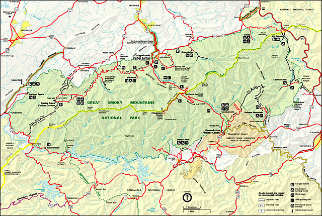
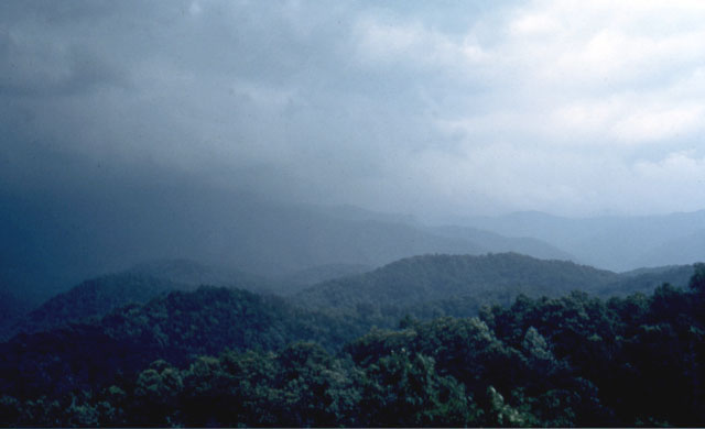
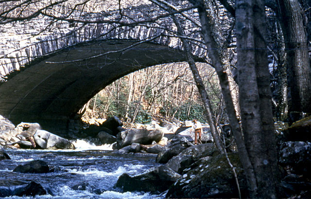
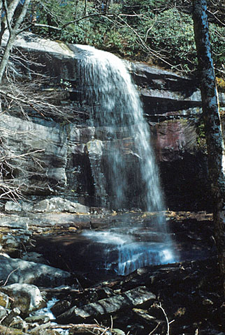
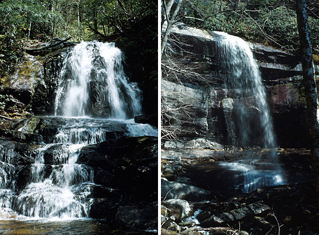
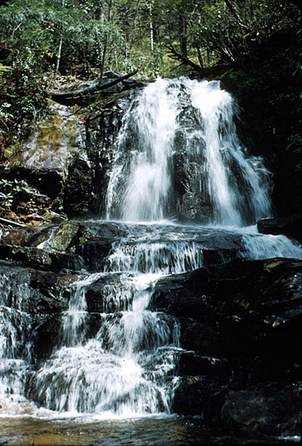
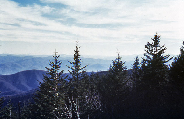
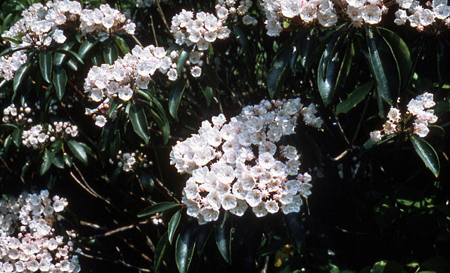
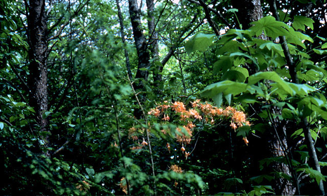
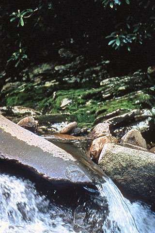
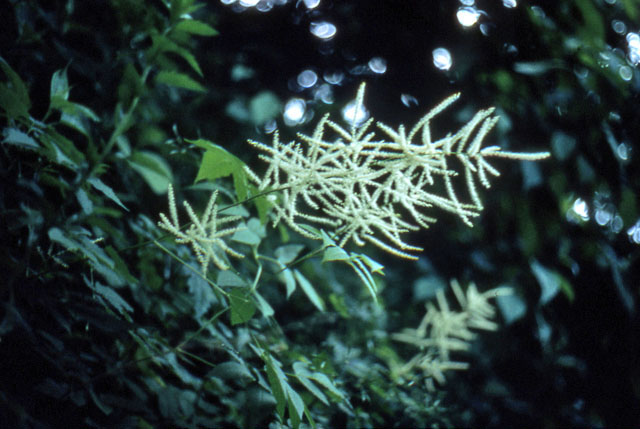
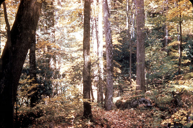
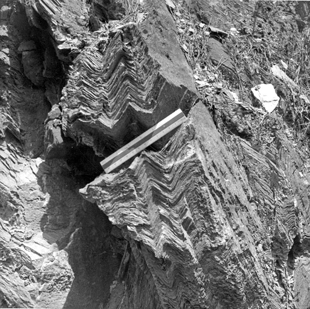
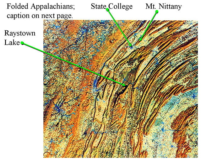
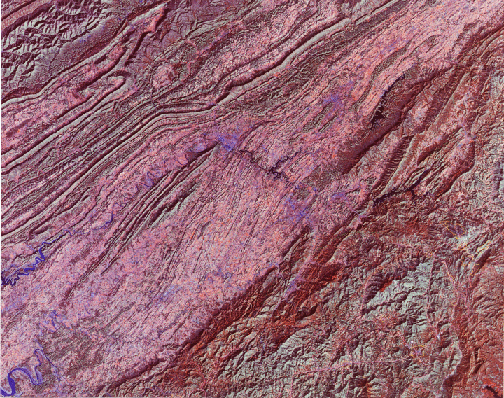
Image 1: Park Service Map of Great Smoky Mountains National Park

Image 2: Thunderstorm over Great Smoky Mountains National Park. The Smokies are the wettest spot in the lower-48 except for the Pacific Northwest, with the high elevations scraping rain out of the sky to water the wonderful forest.

Image 3: A stone bridge over a stream. Caption: Bridge, Great Smoky Mountains National Park. The abundant rainfall in the Smokies feeds numerous beautiful streams, such as seen here and in the next picture; many streams host native brook trout.

Image 4: Close-up view of a stream in the Smokies. There are many large rocks with white water rushing around them.

Image 5: A waterfall in the Smokies. Caption: This photo and the next, from the USGS archives, were taken by W.B. Hamilton in 1954. They show two of the many beautiful waterfalls in the Smokies. A little extra description of waterfalls is inserted between the two.

Image 6: Two waterfalls in the Smokies. Both photos from the USGS archives were taken by W.B. Hamilton in 1954. Caption: Waterfalls usually indicate something interesting in recent geological time; water flows faster and erodes more on steeper slopes, so waterfalls quickly become rapids. Hence, these waterfalls suggest a recent event, perhaps of mountain-building. Yet, the newest scientific studies suggest that conditions have not changed recently. The debate is more than academic; if mountain-building has occurred recently, then the risk of earthquakes is higher than it otherwise would be, with implications for zoning codes and construction practices and emergency services. Although the basic outline of geology is well-known, large and important questions remain!

Image 7: Another Smoky Mountain waterfall photo from the USGS archives, taken by W.B. Hamilton in 1954.

Image 8: Late-autumn view, Great Smoky Mountains National Park. There are evergreens in the foreground, a dark blue ridge directly behind the evergreens, and then many smaller mountain ridges fading into the distance as typical of the Appalachians.

Image 9: Close up of mountain laurel in Great Smoky Mountains National Park. Caption: The ridges of the Smokies are mostly sandstones, metamorphic rocks, and granites, which give rise to fairly acidic soils that are favored by rhododendron, azaleas (next pictures), and Laurel, among others. Limestones in places produce less-acidic soils and host different plants.

Image 10: Flame azalea with orange flowers, Great Smoky Mountains National Park. Caption: About 10,000 species of plants and animals are known to live in the park, and many more are probably present.

Image 11: A stream with rhododendron in the background.

Image 12: Close up of Goat’s-beard, a common wildflower of the Great Smokies. The Goat's-beard has dark green leaves and a plume composed of tiny white flowers.

Image 13: Old-growth forest in Great Smoky Mountains National Park. There are large deciduous trees with smaller evergreens growing below the trees and short undergrowth. Historical (1953) USGS photo by W.B. Hamilton.

Image 14: Metamorphic rocks near Cades Cove, Great Smoky Mountains National Park. Heating caused former muds to change into new minerals, and squeezing caused the prominent folds seen. A rich and varied geological history is recorded in the diverse and beautiful rocks of the Smokies. USGS photo by W.B. Hamilton, 1953.

Image 15: Remote Sensing Image of the folded Appalachians.

Image 16: Remote Sensing Image of the folded Appalachians. The Great Smoky Mountains were raised to their present elevation by obduction, when Africa and Europe collided with North America as the proto-Atlantic Ocean closed. The whole Appalachian chain formed with the Smokies, including the Valley and Ridge Province—the folded Appalachians—in which State College, PA lies. This autumnal NASA photograph shows State College and Mt. Nittany near the top center, as indicated. The ridges appear orange, the valleys white and blue (some of the colorations is “false-color”—NASA takes subtle differences in appearance and makes the differences appear bigger by changing the color scheme), and Lake Raystown is the black body near the center. From NASA’s Remote Sensing Tutorial.

Image 17: Another Remote Sensing Image of the folded Appalachians. The Great Smoky Mountains occupy the lower-right part of this image, with the folded Appalachians across the center and the Cumberland Plateau in the upper left. The false-color image is from the NASA Remote Sensing Tutorial.

Image 18: A crash test car crashed head-on into a wallm with the hood crumpled together. Caption: Obduction, which produced the Great Smokies, the folded Appalachians, the Himalaya, etc., has some things in common with running a car into a brick wall or another car--something long and thin becomes short and thick, with folds and push-together faults. This rather elegant example is from crash-safety testing by the Department of Transportation, Transportation Statistics Annual Report 2000.

Virtual Field Trip #2: Rocky Mountains

National Park Service Map of Rocky Mountain National Park, Colorado.
A quick field trip to Rocky Mountain National Park, Colorado. If you want to see elk, bighorns, big mountains, and big marmots, Rocky Mountain is great AND It has some beautiful metamorphic rocks, which we’ll look at in a minute. All photos by Richard Alley; map from the National Park Service.
A Clark’s Nutcracker (bird) sitting on top of a rock.
Clark’s nutcrackers are well-known moochers at campsites and highway pull off. Feeding the animals is not allowed, however.
Bighorn sheep standing by the side of the road.
Bighorn sheep are common in the park and often come right down by the road near Sheep Lakes in Horseshoe Park.
an elk in a field eating grass.
Elk are also common in the park and make a bit of a nuisance of themselves in nearby Estes Park sometimes. As for students, breakfast is the most important meal of the day for elk.
Mountain peaks with small glaciers rise above Bierstadt Lake
Rocky Mountain is best known for its rocky mountains (duh…). Here, peaks with small glaciers rise above Bierstadt Lake.
Ouzel Lake, one of several lakes that were carved by glaciers in the park
Glaciers carved numerous lakes in the park, to which we will return later. Here is Ouzel Lake (an ouzel, or dipper, is a small gray bird that walks underwater looking for food).
Flattop Mountain crowned by tundra
Flattop Mountain is crowned by tundra, short plants growing on permanently frozen ground (permafrost), another topic for our next visit to the park.
Looking down on glacier-carved Emerald Lake
Glacier-carved Emerald Lake, between Flattop and Hallets Peaks, is beautiful when viewed from above.
Horseshoe Park, a glacier carved valley
Horseshoe Park. Trail Ridge Road runs along beaver ponds in the lower-right side. The ridge behind the beaver ponds is a moraine, pushed up by a glacier that filled the valley beyond during the ice age. Sheep Lakes, in the upper left, are frequented by bighorn sheep.
Alluvial fan from the Lawn Lake Flood.
Alluvial fan from the Lawn Lake Flood. In 1982, a dam failed far above this site, unleashing a flood that killed three people. The road crossing the fan shows the great size of the deposit.
A bog orchid that is found in the park.
On a happier note, the park has glorious wildflowers, such as the bog orchid shown here.
Calypso or fairy-slipper orchids found on the forest floor.
Calypso or fairy-slipper orchids are common on the forest floor on both the east and west sides of the park; this one is in the Wild Basin, an outstanding hiking destination.
This cliff on the side of Hallets Peak is several hundred feet high.
This cliff on the side of Hallets Peak is several hundred feet high. The darker metamorphic rocks are cut by lighter-colored igneous rocks that were squirted in while melted and then froze.
Close up of metamorphic rock  shows layering and folding.
A close-up of a metamorphic rock (called gneiss; nickel for scale) shows beautiful layering and folding that formed when the rock was heated almost to melting. Remarkably, this rock started as mud and then recrystallized under heat and pressure.
Metamorphic rock with a red garnet in the center.
Metamorphic rocks often develop interesting minerals, such as the red garnet in the center of the picture. The rock folded around the harder garnet as it grew from the parent mud.

Virtual Field Trip #2: Rocky Mountains
Click Here for Text Alternative for Virtual Field Trip #2

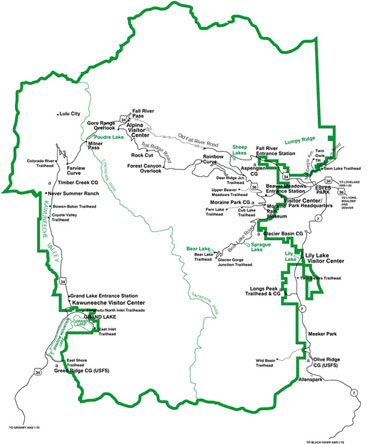
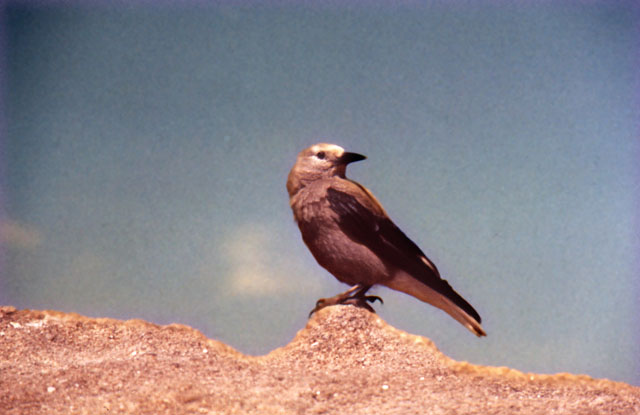
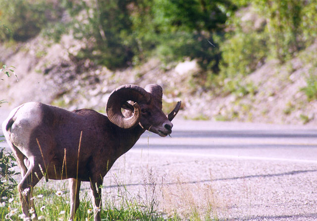
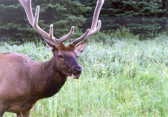
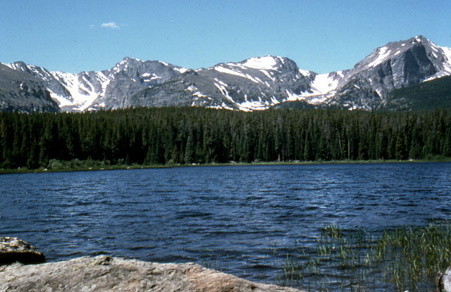
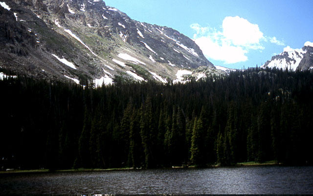
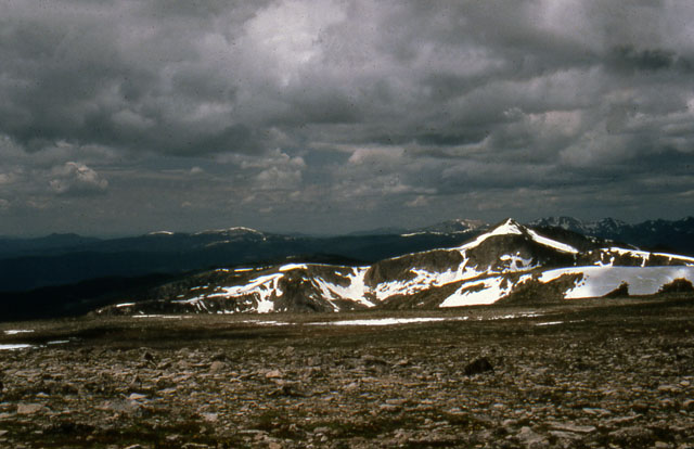
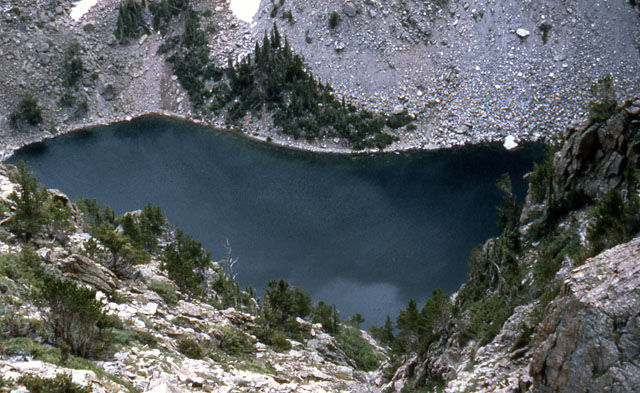
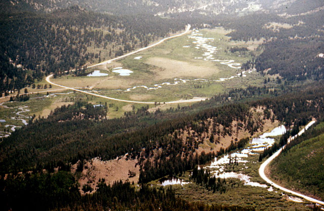
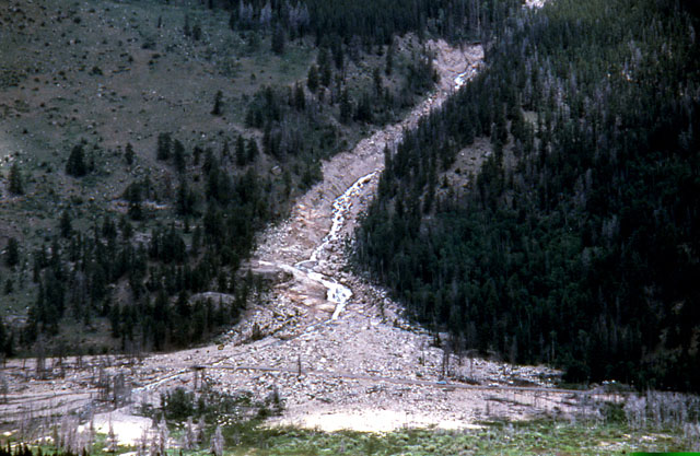
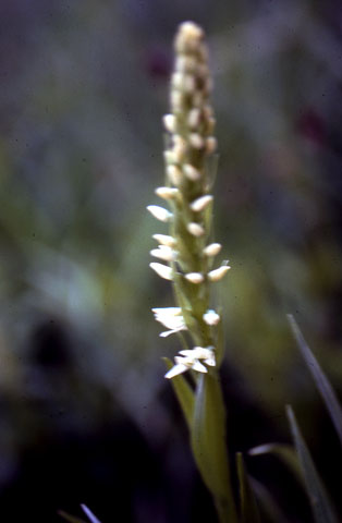
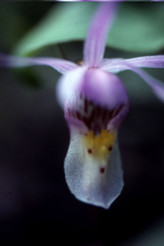
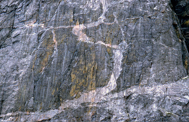
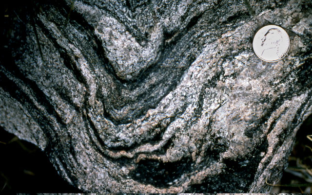
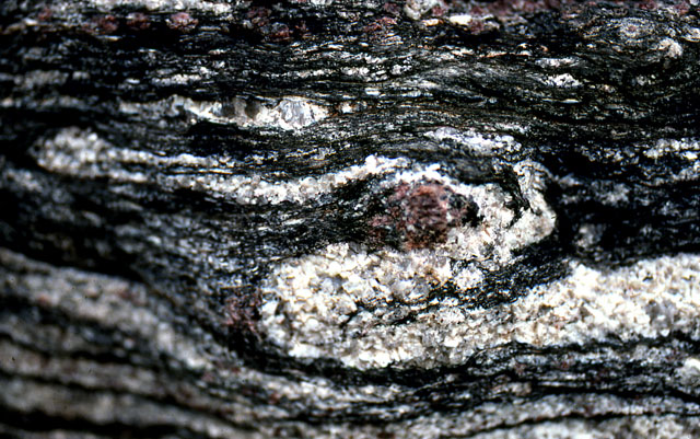
Image 1: National Park map of Rocky Mountain National Park. A quick field trip to Rocky Mountain National Park, Colorado. If you want to see elk, bighorns, big mountains, and big marmots, Rocky Mountain is great AND It has some beautiful metamorphic rocks, which we’ll look at in a minute. All photos by Richard Alley; map from the National Park Service.

Image 2: Clark’s nutcrackers (bird) sitting on a rock. Clark’s nutcrackers are well-known moochers at campsites and highway pull-offs. Feeding the animals is not allowed, however.

Image 3: Bighorn sheep standing beside a road. Bighorn sheep are common in the park and often come right down by the road near Sheep Lakes in Horseshoe Park.

Image 4: Close up of an elk eating grass and wildflowers. Elk are also common in the park and make a bit of a nuisance of themselves in nearby Estes Park sometimes. As for students, breakfast is the most important meal of the day for elk.

Image 5: Rocky Mountain peaks with small glaciers rising above Bierstadt Lake.

Image 6: Rocky Mountain peaks with small glaciers rising above a lake. Glaciers carved numerous lakes in the park, to which we will return later. Here is Ouzel Lake (an ouzel, or dipper, is a small gray bird that walks underwater looking for food.)

Image 7: Top of Flattop Mountain. It is crowned by tundra, short plants growing on permanently frozen ground (permafrost), another topic for our next visit to the park.

Image 8: View of Glacier-carved Emerald Lake, between Flattop and Hallets Peaks, from above. The photographer is standing at the top of a cliff, looking straight down into a lake. The lake is surrounded by mountains.

Image 9: View of Horseshoe Park, a glacier-carved valley. You can see trails, a road, and lakes. Trail Ridge Road runs along beaver ponds in the lower-right side. The ridge behind the beaver ponds is a moraine, pushed up by a glacier that filled the valley beyond during the ice age. Sheep Lakes, in the upper left, are frequented by bighorn sheep.

Image 10: Alluvial fan from the Lawn Lake Flood. In 1982, a dam failed far above this site, unleashing a flood that killed three people and left the trail of sand, rock, and debris running down the mountain and ending in a triangular area of debris. The barely visible road crossing the fan shows the great size of the deposit.

Image 11: Close up of a bog orchid. The park has glorious wildflowers such as this bog orchid.

Image 12: Close up of a calypso or fairy-slipper orchid . Calypso or fairy-slipper orchids are common on the forest floor on both the east and west sides of the park; this one is in the Wild Basin, an outstanding hiking destination.

Image 13: A cliff on the side of Hallets Peak that shows dark metamorphic rock and streaks of lighter colored igneous rocks. This cliff on the side of Hallets Peak is several hundred feet high. The darker metamorphic rocks are cut by lighter-colored igneous rocks that were squirted in while melted and then froze.

Image 14: A close-up of a metamorphic rock (called gneiss) shows beautiful layering and folding that formed when the rock was heated almost to melting. Remarkably, this rock started as mud and then recrystallized under heat and pressure.

Image 15: Metamorphic rock with a red garnet in the center. Metamorphic rocks often develop interesting minerals, such as the red garnet in the center of the picture. The rock folded around the harder garnet as it grew from the parent mud.

Virtual Field Trip #3: Tsunamis

Title page that simply says ‘Tsunamis’.
Tsunamis are among the most deadly natural disasters. Here are a few pictures with captions, for impact.
Map with  arrow pointing to the N. tip of Sumatra.  It says Epicenter Magnitude 9.0, Dec 26, 2004  referring to 2004 Indian Ocean tsunami.
The 2004 Indian Ocean tsunami is among the worst natural disasters ever. An immense earthquake (one of the two or three biggest ever) triggered a wave that killed over 300,000 people. Many of the resources shown here are from the United States Geological Survey.
Tall tree with branches broken off and bark scraped off up to the height of the tsunami.
Branches are broken and bark is scraped off of trees up to the height of the tsunami. The 1.5 m (5 ft) high stick does not come close to the high-water mark, which is off the top of the picture. The cartoon in the next slide shows the water height as up to 28 m (about 100 ft).
Map with arrow pointing to  Lampuuk.  At this location,  the peak water depth was 28 m (nearly 100 ft) above normal water level.
At Lampuuk (location is shown in the inset) the peak water depth was 28 m (nearly 100 ft) above normal water level, and the huge surge pushed well inland. Imagine the last time you were on the beach, at Atlantic City or Virginia Beach, and then mentally put 100 feet of water over the place where you were sunning.
steel reinforced beans broken at the base and laying across the sidewalk.
The inrush of water carrying trees, boats, etc., can have immense force. Here, steel-reinforced beams were broken by the tsunami.
A 2 ft deep hole in the sand.  The sand was found inland.  It was relocated from the shore to Lampuuk by the  tsunami.
The tsunami eroded the coast, and some of the eroded sand was carried far inland and deposited. Here, at the village of Lampuuk, 73 cm (2 ft) of sand was deposited on the dark soil at the bottom. Excavations in coastal regions can find such records of tsunamis, and help learn how frequent they are.
Before and after satellite images showing the coast at Lampuuk.  Before = green and has sand beaches.  After = brown and no sand beaches.
The difference between the before (left) and after (right) pictures of the coast at Lampuuk is sobering indeed. Satellite image acquired using Space Imaging’s IKONOS satellite and processed by the Centre for Remote Imaging, Sensing and Processing (CRISP), National University of Singapore.
Aceh, NW Sumatra, Indonesia: BEFORE the tsunami.
Aceh, NW Sumatra, Indonesia: BEFORE the tsunami Images processed by StormCenter Communications, Inc., Captured by Space Imaging Ikonos Satellite, processed by CRISP-Singapore.
Aceh, NW Sumatra, Indonesia: AFTER the tsunami.  Large parts of the land are under water.  Sinking from earthquake motions also affected this area.
Aceh, NW Sumatra, Indonesia: AFTER the tsunami Images processed by StormCenter Communications, Inc., Captured by Space Imaging Ikonos Satellite, processed by CRISP-Singapore.
Another section of Aceh, NW Sumatra, Indonesia: BEFORE the tsunami.  It is green and lush.
Another Section of Aceh, NW Sumatra, Indonesia: BEFORE the tsunami Images processed by StormCenter Communications, Inc., Captured by Space Imaging Ikonos Satellite, processed by CRISP-Singapore.
Another Section of Aceh, NW Sumatra, Indonesia: AFTER the tsunami.  Now it’s brown and much of it is underwater.
Another Section of Aceh, NW Sumatra, Indonesia: AFTER the tsunami Images processed by StormCenter Communications, Inc., Captured by Space Imaging Ikonos Satellite, processed by CRISP-Singapore.
Seward, Alaska after the 1964 Alaska earthquake.  Houses are leveled and trees are toppled.
The great Alaska earthquake of 1964 generated tsunamis from the plate motions and from landslides, and the tsunamis caused most of the deaths. Damage in Seward is shown here. 1964. Figure 4-D, U.S. Geological Survey Circular 491. Digital File:aeq00016
View of downtown Kodiak, Alaska before  and after the tsunami.  After image = many missing buildings and a boat found inland.
View of downtown Kodiak, Alaska before (top) and after (bottom) the tsunami. Notice the difference in the number of buildings before and after. Also, notice the slightly “out-of-place” boat located in the “rearranged” downtown.
A large tractor trailor bent around a tree with it’s back wheels in the air.  The force of the wave caused this.
This truck was 32 feet above sea level before the tsunami hit, two miles from Seward. The force of the wave bent the truck around the tree.
Blackstone Bay, Alaska.
Blackstone Bay, Alaska. The wave reached 80 feet above sea level, washing snow away (trees are 50-75 feet high). (1964. Figure 14-A, U.S. Geological Survey Circular 491)
Prince William Sound, Alaska with large trees broken off about 4 ft from the ground along the shore of the bay.
Prince William Sound, Alaska. Trees up to two feet in diameter were splintered by a tsunami from an earthquake-triggered underwater landslide. Since then, the Trans-Alaska oil pipeline was built, ending near here.
Man holding a large tire with a two by four sticking straight through the rubber part of the tire.
Near Whittier, Alaska. The strength of the wave, and the strange things that happen when a whole lot of energy is let loose are evident. ( U.S. Geological Survey Professional Paper 542-B.)

Virtual Field Trip #3: Tsunamis
Click Here for Text Alternative for Virtual Field Trip #3

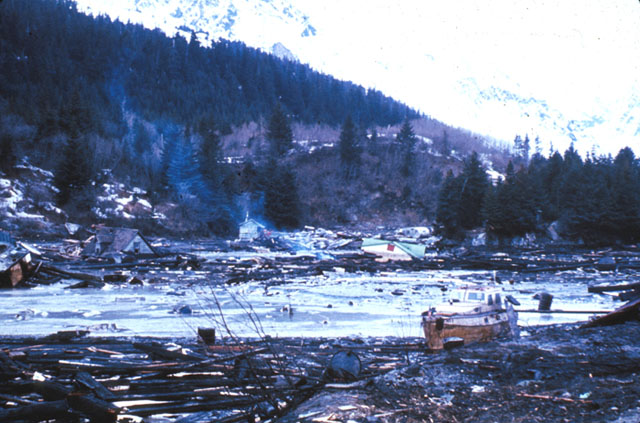
Image 1: Title page that simply says ‘Tsunamis’. Tsunamis are among the most deadly natural disasters.

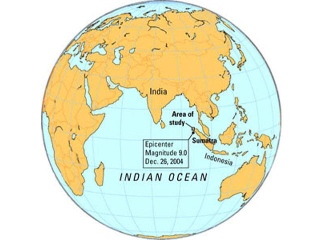
Image 2: Map with an arrow pointing to the N. tip of Sumatra. It says Epicenter Magnitude 9.0, Dec 26, 2004, referring to the 2004 Indian Ocean tsunami. The 2004 Indian Ocean tsunami is among the worst natural disasters ever. An immense earthquake (one of the two or three biggest ever) triggered a wave that killed over 300,000 people. Many of the resources shown here are from the United States Geological Survey.

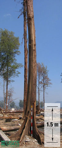
Image 3: Tall tree with branches broken off and bark scraped off up to the height of the tsunami. It has a 1.5 meter stick leaning against the base for reference. Branches are broken and bark is scraped off of trees up to the height of the tsunami. The 1.5 m (5 ft) high stick does not come close to the high-water mark, which is off the top of the picture.

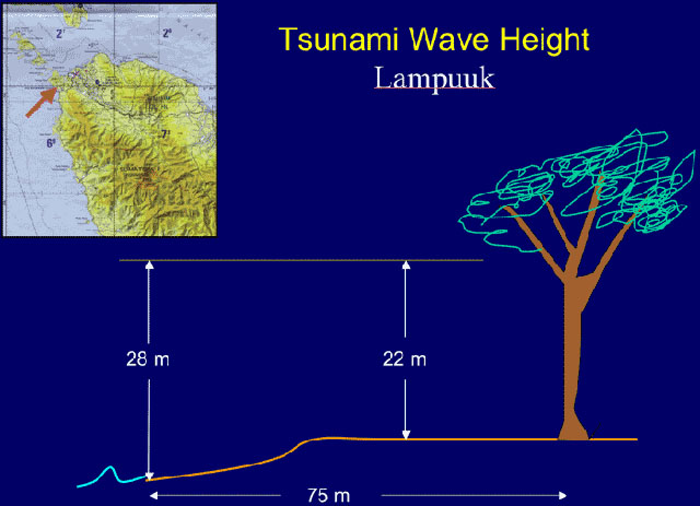
Image 4: Map with an arrow pointing to Lampuuk. At Lampuuk the peak water depth was 28 m (nearly 100 ft) above normal water level, and the huge surge pushed well inland. Imagine the last time you were on the beach, at Atlantic City or Virginia Beach, and then mentally put 100 feet of water over the place where you were sunning.

Image 5: Steel reinforced beams broken at the base and laying across the sidewalk. The inrush of water carrying trees, boats, etc. can have immense force. Here, steel-reinforced beams were broken by the tsunami.

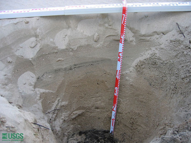
Image 6: A 2 ft deep hole in the sand. The sand was found inland. It was relocated from the shore to Lampuuk by the tsunami. The tsunami eroded the coast, and some of the eroded sand was carried far inland and deposited. Here, at the village of Lampuuk, 73 cm (2 ft) of sand was deposited on the dark soil at the bottom. Excavations in coastal regions can find such records of tsunamis, and help learn how frequent they are.

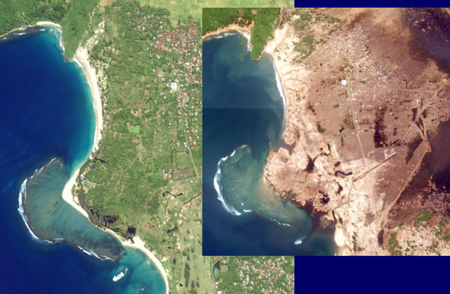
Image 7: Before and after satellite images showing the coast at Lampuuk. Before = green and has sandy beaches. After = brown and no sand beaches.

Image 8: Aceh, NW Sumatra, Indonesia: BEFORE the tsunami. Images processed by StormCenter Communications, Inc., Captured by Space Imaging Ikonos Satellite, processed by CRISP-Singapore.

Image 9: Aceh, NW Sumatra, Indonesia: AFTER the tsunami. Large parts of the land are under water and all of the land is brown rather than green. Text on the image says "sinking from earthquake motions also affected this area."

Image 10: Another section of Aceh, NW Sumatra, Indonesia: BEFORE the tsunami. It is green and lush.

Image 11: Another Section of Aceh, NW Sumatra, Indonesia: AFTER the tsunami. Now it’s brown and much of it is underwater.

Image 12: Seward, Alaska after the 1964 Alaska earthquake. Houses are leveled and trees are toppled. The great Alaska earthquake of 1964 generated tsunamis from the plate motions and from landslides and the tsunamis caused most of the deaths. Damage in Seward is shown here. 1964. Figure 4-D, U.S. Geological Survey Circular 491. Digital File:aeq00016

Image 13: View of downtown Kodiak, Alaska, before and after the tsunami. The after image has many missing buildings and a boat found inland.

p>Image 14: A large tractor-trailer bent around a tree with its back wheels in the air. This truck was 32 feet above sea level before the tsunami hit, two miles from Seward. The force of the wave bent the truck around the tree.

Image 15: Blackstone Bay, Alaska. The wave reached 80 feet above sea level, washing the snow away (trees are 50-75 feet high). ( 1964. Figure 14-A, U.S. Geological Survey Circular 491 )

Image 16: Prince William Sound, Alaska. Man is standing along the coast, surrounded by trees up to two feet in diameter that were splintered by a tsunami from an earthquake-triggered underwater landslide. Since then, the Trans-Alaska oil pipeline was built, ending near here.

Image 17: Man holding a large tire with a two by four sticking straight through the rubber part of the tire near Whittier, Alaska. This shows the strength of the wave and the strange things that happen when a whole lot of energy is let loose.

Virtual Field Trip #4: Blue Ridge Mountains

winding road along the Blue Ridge Parkway, Virginia, in January. There are no leaves on the trees.
The Blue Ridge Parkway, Virginia, in January, plus some other Appalachian pictures. All photos by R. Alley. The Blue Ridge runs north from the Great Smokies into Pennsylvania. Along the top is one of the world’s best reasons for hiking boots, the Appalachian Trail. Also up there for less-dedicated hikers is the Blue Ridge Parkway, one of the National Park Service’s wonderful by-ways. Most visitors favor summer, but the rocks show better in winter.
Three pictures.  1. a house on a hill.  2. an old fence.  3.  a rock wall.  These images show human settlement along the Blue Ridge Parkway.
The Blue Ridge has a long history of human settlement. The low stone wall above helped control hogs.
Wild turkey on the forest floor and a red-tailed hawk in the trees.
Logging greatly changed the Blue Ridge, but now that large areas are protected, much of the wildlife has returned, including the wild turkey (left) and red-tailed hawk (right).
Three pictures.  1.  The reconstructed narrow-gauge railroad tracks,. 2. Tulip tree branches. 3. Two hairy sumac stems.
The reconstructed narrow-gauge railroad is like those used in logging tulip (upper right) and other trees a century or more ago. The hairy sumac, (above left), is outlined against taller trees behind.
Two images.  1.  Waterfall.  2. The Blue Ridge Mountains with fog in the valleys.
(top) Abundant rainfall feeds numerous streams that are cutting into the high Blue Ridge, such as the waterfall cascading over granite. (bottom) The Blue Ridge is high primarily because its rocks are harder than those in the valleys—erosion has lowered the valleys more than the mountain.
Close up of sedimentary rocks found in the Blue Ridge Mountains.
The Blue Ridge rocks include formerly sedimentary rocks—old muds and sands—that were metamorphosed by heat and squeezing deep in the Earth, tipped up on end, and then exposed by erosion.
Two close ups of sedimentary rocks.  1.  Sanding-on-end layers. 2. Layer with the track of a snail going through it.
The standing-on-end layers of rock (top) attest to the great stresses in the mountain-building. But look at the side of a layer and you may see the track of a snail or other animal, from when the rocks were still soft mud (arrow, bottom picture).
a large outcropping of greenish rock called greenstone
This greenish rock is greenstone, an old lava flow that has been metamorphosed by heat and pressure deep in a mountain range.
Sideling Hill road cut, Interstate 68, western Maryland
Sideling Hill road cut, Interstate 68, western Maryland. The visitor center with its over-the-road viewing area is well worth the stop. West of the Blue Ridge, the rocks are not as metamorphosed, but they were still bent by the obduction-collision between North America and Africa. Erosion has left the hardest rocks highest; here, those are rocks that were squeezed at the bottom of a fold.
Sideling Hill road cut along I68 in western Maryland
Another view of the Sideling Hill road cut along I68 in western Maryland. Folding squeezes the inside of a curve and stretches the outside. Fold a thick phone book and you’ll see this behavior. The arrows show the broken ends where squeezing on the inside of the fold split a layer and pushed one side over the other.
Appalachian mountains at dusk.
The folded rocks of this obduction zone, like wrinkles in a carpet, give the beautiful ridges that we know as the Appalachians.

Virtual Field Trip #4: Blue Ridge Mountains
Click Here for Text Alternative for Virtual Field Trip #4

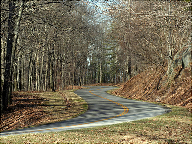
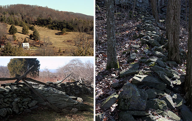
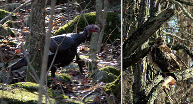
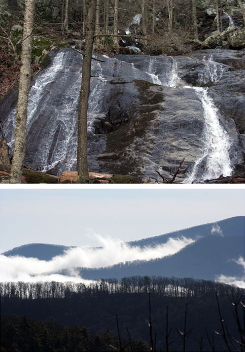
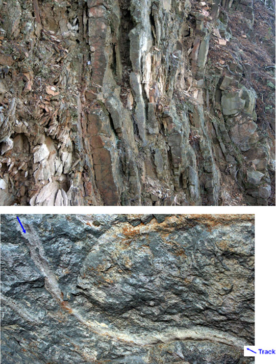
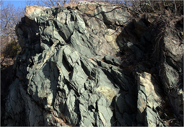
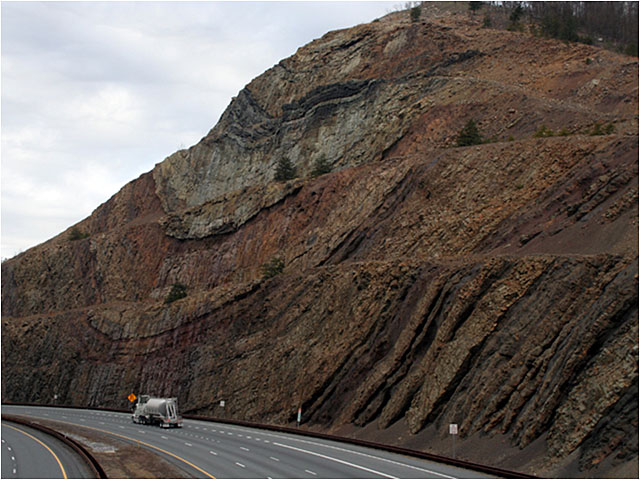
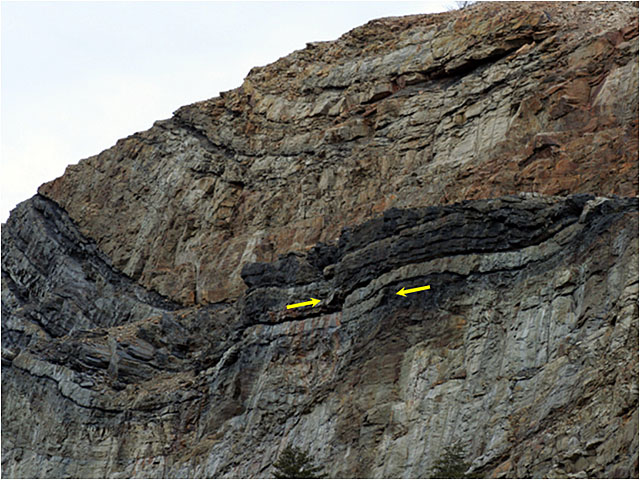
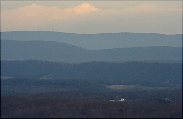
Image 1: A winding road through the Blue Ridge Parkway, Virginia, in January - there are no leaves on the trees. The Blue Ridge runs north from the Great Smokies into Pennsylvania. Along the top is one of the world’s best reasons for hiking boots, the Appalachian Trail. Also up there for less-dedicated hikers is the Blue Ridge Parkway, one of the National Park Service’s wonderful by-ways. Most visitors favor summer, but the rocks show better in winter.

Image 2: Three images showing the long history of human settlement in the Blue Ridge Mountains. One shows a house on a hill, one shows a stone wall that was used to help control hogs, and the other shows a path through the woods. The Blue Ridge has a long history of human settlement. 

Image 3: Two images. Left, a turkey in the undergrowth. Right, an red-tailed hawk sitting in a tree. Logging greatly changed the Blue Ridge, but now that large areas are protected, much of the wildlife has returned, including the wild turkey and red-tailed hawk.

Image 4: Three images. Left, a hairy sumac tree, top right, a tulip tree with buds. Bottom right, a reconstructed narrow gauge railroad that is like those used to log tulip and other trees a century or more ago.

Image 5: Two images. Top, a waterfall cascading over granite. Bottom, fog in the valleys of the Blue Ridge. Abundant rainfall feeds numerous streams that are cutting into the high Blue Ridge, such as the waterfall cascading over granite. The Blue Ridge is high because its rocks are harder than those in the valleys. Erosion has lowered the valleys more than the mountain.

Image 6: Two images of rocks. The Blue Ridge rocks include formerly sedimentary rocks – old muds and sands – that were metamorphosed by heat and squeezing deep in the Earth, tipped up on end, and then exposed by erosion.

Image 7: Two images. Top shows layers of rock running vertically to the ground. Bottom, a snail path in the hardened rock. The standing-on-end layers of rock (top) attest to the great stresses in mountain-building. But look at the side of a layer, and you may see the track of a snail or other animal, from when the rocks were still soft mud.

Image 8: This greenish rock is greenstone

Image 9: A greenish rock outcropping. The greenish rock is greenstone, an old lava flow that has been metamorphosed by heat and pressure deep in a mountain range. Sideling Hill road cut, Interstate 68, western Maryland.

Image 10: A truck driving by on the highway next to Sideling Hill road cut along I68 in western Maryland. Folding squeezes the inside of a curve and stretches the outside. Fold a thick phone book and you’ll see this behavior. The arrows show the broken ends, where squeezing on the inside of the fold split a layer and pushed one side over the other.

Image 11: Another view of Sideling Hill road cut. The folded rocks of this obduction zone, like wrinkles in a carpet, give the beautiful ridges that we know as the Appalachians.

Image 12: image with the ridges of the Appalachians in the distance. The folded rocks of this obduction zone, like wrinkles in a carpet, give the beautiful ridges that we know as the Appalachians.

Word Document of Unit 4 V-trips

Want to see more?

Here are some optional vTrips you might also want to explore! (No, these won't be on the quiz!)

Death Valley National Park
(Provided by UCGS)

Death Valley National Park - 3D version
(Provided by UCGS - red/cyan stereo viewing glasses required)