Errors and uncertainty are inherent in geographic data. Despite the best efforts of the USGS Mapping Division and its contractors, topographic maps include features that are out of place, features that are named or symbolized incorrectly, and features that are out of date.
As discussed in Chapter 2, the locational accuracy of spatial features encoded in USGS topographic maps and data are guaranteed to conform to National Map Accuracy Standards. The standard for topographic maps state that horizontal positions of 90 percent of the well-defined points tested will occur within 0.02 inches (map distance) of their actual positions. Similarly, the vertical positions of 90 percent of well-defined points tested are to be true to within one-half of the contour interval. Both standards, remember, are scale-dependent.
Objective standards do not exist for the accuracy of attributes associated with geographic features. Attribute errors certainly do occur, however. A chronicler of the national mapping program (Thompson, 1988, p. 106) recalls a worried user who complained to USGS that "My faith in map accuracy received a jolt when I noted that on the map the borough water reservoir is shown as a sewage treatment plant."
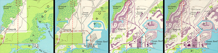
The passage of time is perhaps the most troublesome source of errors on topographic maps. As mentioned in the previous page, the average age of USGS topographic maps is over 20 years. Geographic data quickly lose value (except for historical analyses) unless they are continually revised. The sequence of map fragments below show how frequently revisions were required between 1949 and 1973 for the quad that covers Key Largo, Florida. Revisions are based primarily on geographic data produced by aerial photography.
Try This!
Investigate standards for data quality and other characteristics of U.S. national map data here or by searching the Internet for "usgs national map accuracy standards".