The subject of control and georeferencing of a photogrammetric block could be the subject of several lessons in a course dedicated entirely to photogrammetry. I'm going to do my best to explain it conceptually without the math. Earlier in this lesson, you learned about the six parameters of exterior orientation that define the geometric relationship between an aerial photograph and the ground. I explained space resection and the way a minimum number of ground points can be used to solve the exterior orientation of a single vertical photograph. You may have thought to yourself how labor-intensive, expensive, and impractical it would be to actually solve the exterior orientation of each individual photograph in a large block by this method.
Photogrammetric mapping, based on very large blocks of hundreds or even thousands of aerial photographs, was made practical by the development of a technique called aerotriangulation, sometimes also called aerial triangulation, and often abbreviated as “A/T.” This short video from ASPRS gives an overview of the concept, but a deep understanding comes from either years of training under a master, or a rigorous study of the mathematics. My reference to a master may sound a little overblown, but in my years of experience managing photogrammetric projects, a bad aerotriangulation solution that goes undetected is one of the most costly and time-consuming problems to correct. A/T is usually performed by the most experienced photogrammetrist in the organization, and there simply aren't that many true experts in it, perhaps a thousand or two at most worldwide. There are many software programs available to compute an A/T adjustment, but it’s easier to get a bad result than a good one, especially if the person designing the block and evaluating the statistical results doesn't have a deep theoretical understanding combined with a lot of practical experience.
The easiest way I have found to simply explain the concept of aerotriangulation is an extension of my desktop analogy. Picture again the bundles of intersecting rays generated by two overlapping photographs; the figure below depicts 3 photos in a single flight line. Now extend that picture in your mind's eye to include a second flight line "side-lapping" the first, also imaging points A, D, and G on the ground.
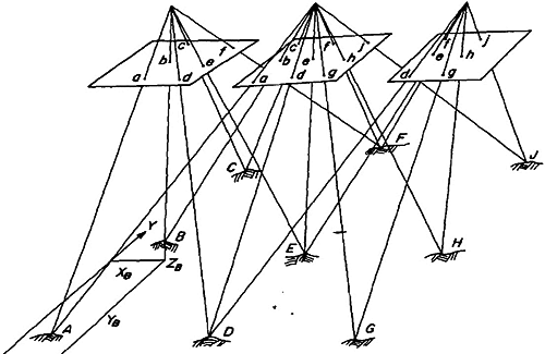
Point D, for example, is seen from 3 perspectives in the first flight line, and from another 3 perspectives in the side-lapping flight line I've asked you to visualize. Imagine that both flight lines continue on with many more end-lapping photos. All points common to adjacent flight lines, such as points D, G, and beyond, are going to be viewed with 6 intersecting rays. Even if we did not have a ground coordinate for every single one of these "tie points," you can imagine that, by enforcing the condition that the 6 rays must precisely intersect, there is still a lot of geometric stability in the block. This is the basic premise of aerotriangulation: enforcing the collinearity condition and the redundant intersection of image rays in "object space" creates a bridge from one photo to the next, thereby reducing the amount of ground control needed to reconstruct the exterior orientation for every photo.
If GPS/IMU direct georeferencing is available, the effect is to add additional control at each of the camera focal points, the photo centers, as they are often called. Remember that direct georeferencing gives us the 6 parameters of exterior orientation for every photo. We can use the direct georeferencing measurements as the first approximation of the aerotriangulation solution, and we no longer need actual ground control points. The GPS/IMU measurements for each photo center will inevitably contain errors, but we can reduce the impact of these errors in subsequent iterations of the block adjustment computation, simply by enforcing ray intersection for all the image tie points. This is done mathematically for all photos in the entire block simultaneously, and the A/T results give the photogrammetrist a quantitative assessment of the "goodness of fit" for this system of many redundant observations.