
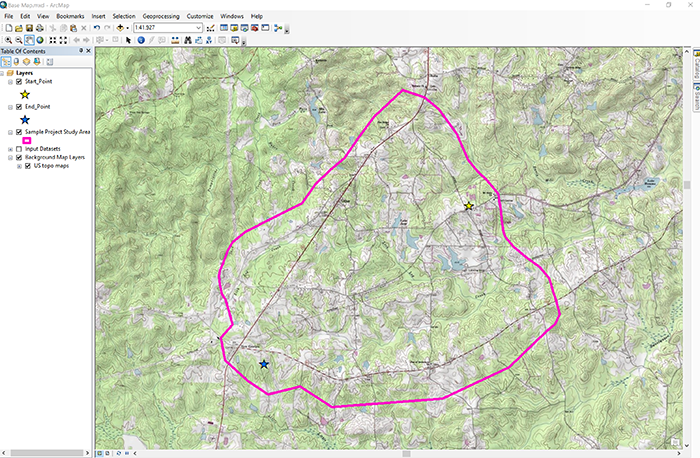
Champlain Power, Inc. has submitted a request to the Georgia State Public Service Commission (GSPSC) to construct, operate, and maintain an overhead 345 kV High Voltage Direct Current transmission line named the "Nebo-Baskins Road Interconnect."The line would begin near Nebo just northeast of Dallas Nebo Road (Start Point) and run southwest to an existing substation southwest of Baskin Road (End Point) (Figure 9.2). The proposed transmission line will be approximately 3.5 miles in length, depending on the final siting decision for the line route. The public outreach and GSPSC reviews should be finalized by April 1, 2019. Construct on the new transmission line is expected to start in January, 2020.
This interconnect is needed to meet the projected demand for new residential, commercial, and light industrial service in the area. The United States Census, the Georgia Economic Development Agency, and local government data all point to increasing current and future needs for infrastructure additions to meet this growing demand. Internal projections made by Champlain Power also suggest the need to increase electric capacity to the area to meet future projected needs. Currently, the area serviced by Champlain Power serves approximately 150,000 residential customers; 7,500 commercial customers; and 1,200 light-industrial customers. Future demand projections (2020-2050) suggest the electric services will increase to 300,000 residential; 18,000 commercial; and 1,500 light-industrial customers. This demand cannot be met by the existing electric service, and a major expansion is required to meet this anticipated increase.
Champlain Power has selected three potential corridors for the planned overhead line interconnect. From these three corridors, a preferred corridor will be selected. Additional siting analysis will then be conducted to select the most appropriate route based on optimum natural environment, built environment and engineering environment criteria. This final route will be submitted to the GSPSC for review and approval. Initial construction will commence within 60 days of final GSPSC approval.
For the term project, you have been assigned as the project manager for siting the Nebo-Baskins Road Interconnect Transmission Line.You will be responsible for leading a team that will have full responsibility for selecting a preferred corridor, conducting the additional siting analysis, and selecting the most appropriate route for review and approval by the GSPSC. In addition, you will responsible for managing all community information outreach programs to keep the general public informed of the siting process and progress. The following two videos will give you a brief introduction to the project:
Click for a transcript of "Introduction" video.
PRESENTER: This is a Google Earth view of the term project study area. The study area is inside the pink boundary. Now, one of your tasks for the term project is to locate three alternate routes through study area between the start point and the end point. But to complicate the route selection, you will need to consider the impacts on the built and natural environment.
These impacts include buildings, which I'll turn those on for you. You can see the buildings and their building footprints. Avoidances, let me click on that for you. You have the avoidances and avoidances include such things as schools, daycare centers, churches, cemeteries, and things of that nature.
Now, the next thing that you have to take a look at will be large building footprints. Obviously, we don't want a transmission line going over a large building. Then, we'll take a look at the conservation areas, and the conservation areas include a number of things. They include lakes, wetlands, and in this instance, they also include some floodplain areas. So then, your mission is to locate three alternate routes and then select the best route that minimizes impacts to the natural and built environment.
Good luck. The second video will give you a unique look at a fly-through of an example alternative route to give you a feel for the obstacles and questions you could encounter with your route selection.
PRESENTER: What I want to do is show you the lay of the land using a flythrough created in Google Earth. I have defined a typical alternate transmission line route through the study area, similar to the alternate routes you will create in your term project. Along the way, we will stop at numerous locations to view the surrounding areas and ask some questions.
As we start the flythrough, what you see is a thin white line and two red lines. The white line is the alternate route, and the red lines are the boundaries, or the right of way for the route. OK, so let's start to tour.
This tour starts at the end of the alternate route and works back to the start point. As we start our flythrough, we fly over alternate forest and agriculture land uses.
Stop 1. Our first stop is near a single-family residence on the right. What potential impacts, if any, to the resident can be associated with the location of the route?
As we proceed, we again encounter alternate forest and agricultural land uses. What would be some of the impacts associated with these types of land uses?
Stop 2. Our second stop shows a route passing over a small farm pond. When locating alternate routes, you want to minimize impacts to the natural environment as much as possible.
Sometimes, that may not be possible. But in this instance, the route could be moved to eliminate this impact. Continuing on our tour, we again pass long stretches of forest and agriculture land use. In addition, we encounter changes in topography. How do you think these topographical changes could impact the location of the proposed route?
Stop 3. It appears the alternate route goes directly through a planned subdivision. In this instance, the route would need adjustments to miss the subdivision. A more appropriate location may be to the right of the planned subdivision. Continuing, we again pass over long stretches of forest and agriculture land, minimizing our impacts to the built environment.
Stop 4. We encounter our first major hurdle, a conservation area including a large lake. In this instance, we may have no viable alternative, and this is our best location. What impacts do you recognize here? As we continue our flythrough, we again encounter a large area of forest land and agriculture land use before we arrive at our starting point.
Stop 5. The question is, can we define a better route? As we come to the end of the flythrough, you have seen some of the obstacles needing resolution, and typical questions that require answers before you can select a final route.