WELCOME TO GEOGRAPHY 488 & Software Download: Acquiring and Integrating Geospatial Data
Welcome to Geography 488. Over the next ten weeks you will encounter 9 lessons and one final project. Lessons are largely module based. These modules combine to provide much of the content of the final project. The final project is a problem based learning, self directed, project. You should already know your fellow classmates to some extent. This usually means that there is less activity on the discussion forums than there was in the early classes. I really encourage message board discussions and there is a required discussion forum component each week. Please don't hesitate to ask questions. I am happy to answer private e-mails, but prefer class discussions in which everyone participates in problem solving.
Acquiring and Integrating Geospatial Data is a daunting course title. The topic is very broad and any number of things could be covered. As you can see in the syllabus, a lot of topics will be covered in this course, but certainly not all of the things associated with identifying, collecting, creating, and using geospatial data. One of the first steps in the design of a GIS or of any project or program should be a user needs analysis. This is where the needs are assessed in terms of the final product. This does not mean that the same methods as the existing system need to be adopted, just that the end product should fulfill the needs that have been identified. Therefore we will take the same approach for this class.
Course Format
In this program, you are our client. We have not done individual needs analyses with everyone, but we have input from you and from other professionals in the industry and have a sense of the existing needs, which we hope closely match what you are looking to get out of the program. What is it that you need? What things have already been checked off the list as a result of taking the prerequisites to this course? You've had a great introduction into the fundamental concepts of geographic information systems and science. You've had a fair amount of exposure to a number of elements of GIS and have had experience with processes and operations within a software system. There are sure to be many things left.
In this course we'll cover such things as data needs assessment, metadata content standards, legal and ethical issues related to data use, data formats and types, data conversion, interoperability, field collection methods, and contributing data for public use. Those who successfully complete the course will be able to "spec out" a GIS project, identify appropriate and cost-effective data sources, create data dictionaries, assess and ensure data quality, determine appropriate data formats given an intended data use, transform data from one format to another and understand GIS software functionality related to data conversion. This course generally follows the processing of data as identified by Safe Software: Define, Evaluate, Extract, Transform, and finally Load the data.
We will only briefly cover the needs assessment. The modules and projects are designed to be highly individualized and I hope that you will feel empowered to contribute your own knowledge, experience, and data.
This course is a little different from earlier courses as it is problem based with you learning through the process. The courses you've taken in the program until now have been highly structured. This course will rely mainly on input from you. Class discussions and a cumulative document or e-portfolio will be fueled by the information you collect. There will also be a larger reading and writing component in this class than the ones leading up to it. I don't need to tell you that good writing and communication skills are an integral part of the profession. In addition to the course project, there is a course paper. This is a fairly low stakes paper of only 1000 - 1200 words, but it is a way for you to share your knowledge or research while demonstrating your writing skills. We expect quality work - nothing less than an instructor teaching an English class on campus would expect. No busy work will be assigned. When possible, assignments will be focused around your areas of expertise, as related to the course. Everyone in the course, including me, should benefit from course submissions.
Problem Based Learning
This course is a little different in that it follows a "Problem Based Learning" approach. You may wish to visit the Wikipedia site for more information about Problem Based Learning. Throughout this course, you will be working toward one final course project deliverable. There will be benchmarks along the way to measure progress, but each week you will focus on that final product. The culminating project will be a GIS plan or conceptual design for your local area - "your story". This plan will vary greatly for each of you. Some of you may live in areas where GIS is very mature, while others may live somewhere that has not started a GIS effort. You will go through the whole spectrum of tasks related to creating a GIS plan, from assessing the current situation, to acquiring data that already exist, to integrating data from various sources, to creating some of your own data, and finally to publishing data so that others have access to them.
Syllabus
I invite you to take a look at the course syllabus. Is there anything that you would like to see covered that isn't? Please feel free to post suggestions to the discussion forums. Because this class does cover such a broad range of topics, it is possible, even likely, that you will have experience with one or more of the topics. I do not claim to be an expert in any of these subject areas. My role in this course is to gather relevant information to share with you, facilitate discussions, and provide guidance. Your insights and input can be incorporated back into the projects and can benefit those in successive offerings of the course. It is my hope that the development of this course will never end. I like to take advantage of the Web as a medium and I have the luxury of being able to update course content daily. Please help me make this course a worthwhile experience for everyone in it.
Let's now take a look at where the course is going over the next ten weeks.
Software
Besides the usual ArcGIS software we have been using we will also have an introduction into Safe Software's Feature Manipulation Engine, here is a link to Safe. Please review the software requirements and down load the software and apply for your time restricted license.
- FME Instructions: Go to Safe Home Page and download trial copy of FME software
- You now need to apply for the 70 day license from the Instructor not Safe.
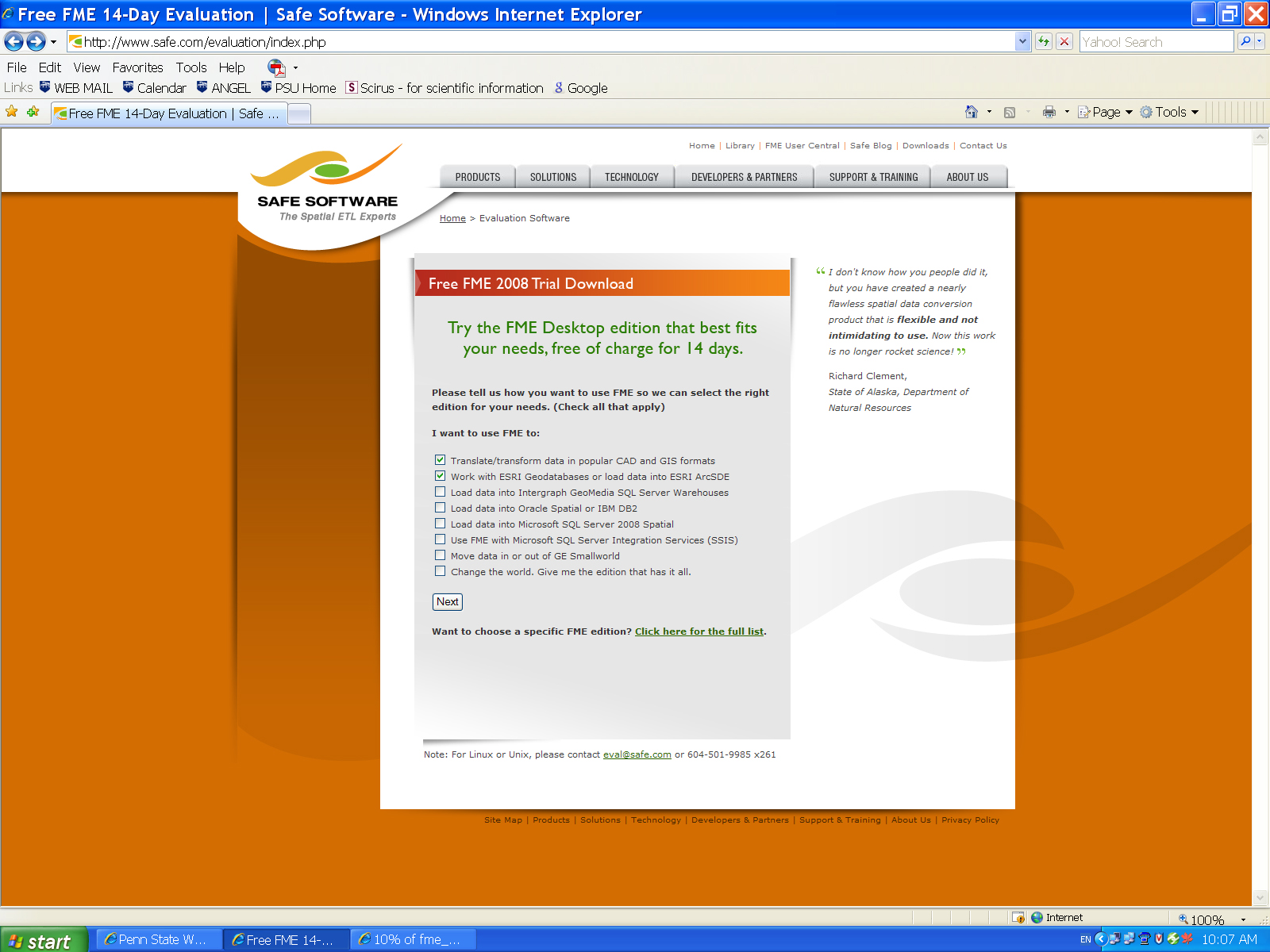
- Open the download Page Safe Evaluation
- Check boxes for:
Translate/transform data in popular CAD and GIS formats and Work with ESRI Geodatabases or load data into ESRI ArcSDE . Click here for an example. - Download Program and install
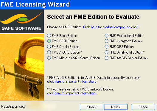
- Make sure you select the ESRI FME edition not the ESRI ArcGIS edition
- Click here for an example.
- Download the file and install it.
- Close the pop-up window licensing window.
- To obtain a Training License for 70 days send me the 10 Digit Registration Key from the lower left side of the program registration window.
- Do not apply for the license from Safe I will send you the license
- I will send you the program registration file as soon you receive it place it in the Safe Installation Folder called Licensing.
- Start using the software, remember this lasts only 70 days before it times out and it is restricted to one machine.
- Support for the Safe Software FME is through the course instructor not Safe Software or World Campus.
Readings and Data
Many of the readings for the course are available through weblinks through open access. Some readings are reserved through ANGEL and only registered students have access through their ANGEL Login. All propriety example data is restricted to registered students in ANGEL.
Roadmap for the Course
Projects 1,2: Assessing and Defining ![]() Projects 3,4: Evaluating and Acquiring
Projects 3,4: Evaluating and Acquiring ![]() Projects 5/6: Extracting, Integrating, and Transforming
Projects 5/6: Extracting, Integrating, and Transforming![]() Project 7/8: Creating, and Loading
Project 7/8: Creating, and Loading ![]() Project 9/10: Publishing
Project 9/10: Publishing
Assessing and acquiring GIS data can be quite time consuming. I will not ask you to do anything I haven't done myself. I've been working on gathering data for my local area. The way we'll approach this course is for me to tell you "my story" each week and then I'll ask you to tell "your story".
Our Story:
Because we have students from all over the country (and sometimes from other countries) we can use the idea of The National Map as a unifying concept. The National Map is in its earliest stages and there is a wide spectrum of opinions about its goals, worth, and ultimate success. However, we can all use the vision of The National Map to guide us in how we approach our own local situation.
The National Map is a multi-agency, coordinated effort to produce current maps based on the best available digital datasets. These data most often reside at the local level. Therefore, funding and standards flow (theoretically and ideally) from federal agencies to the states and local government agencies, and the data flow back up from local entities to regional, state, and federal groups that will compile The National Map.
Framework data layers provide the foundation for The National Map. Generic data schemas define the framework and help ensure that the best available data will be integrated into The National Map. When agencies at all levels use the same schemas, local data stewards can maintain and deliver current data to state and federal agencies. Data distribution and sharing become much easier. By developing data schemas, there can be interaction across the different tiers of government, and a "National" Map can be constructed.
National Map Layers:
- Reference (map grids and labeled tics)
- Transportation (roads, rails, infrastructure, cartographic features, etc.)
- Cultural (human activity layers)
- Administrative (administrative and legal boundaries)
- Hydrography (water features)
- Hypsography (contours, elevation points, TINS, DEMS, etc.)
- Surface Overlays (land cover, land use, soils, etc.)
- Image Base (orthos, DRGs, historical images, etc.)
- Page Layout Design (map templates)
The story you tell in your project may or may not involve those particular layers, but you can assume that some local data in your area are the best available digital datasets and might be a valuable component of The National Map.
The story I will tell throughout the course is about the local water authority in my area and their progress with GIS. I have assessed (and will continue to assess) where they stand with GIS and what they will do in the future. Many of the local basemap layers are important to the authority and would also be an important contribution to The National Map. I've been out in the community tracking down data, so I can appreciate how challenging it will be. Each week, you will hear my data acquisition and integration story. I have tried to weave the learning objectives of the course into the story I am telling about the local water authority. The course project is not about the quantity of data you collect, but rather about thoughtfulness and resourcefulness.
Questions?
That's it for our course introduction!
If you have any questions now or at any point during this lesson, please feel free to post them to the Course Orientation Discussion Forum. That forum can be accessed at any time by clicking on the Forums link in the Resources menu on the left. Be sure to post to the appropriate lesson forum.)
Now, let's continue on with the Orientation...