Introduction
This week’s lesson focuses on reading cultural landscapes. This is not just a theoretical pursuit; it is a means of both collecting and analyzing real-world data that enables one to understand the everyday use of places and the significance that places may hold for people. Individual buildings are tied together by the landscape; the landscape itself is the setting for our daily interactions within a place. Reading the landscape can provide information crucial to a range of intelligence and human security concerns, whether your interest is in determining how to prepare a vulnerable neighborhood for a major hurricane or discover the base of operations of a terrorist cell.
It is also a skill that requires practice in order to fully appreciate what it can reveal about a place. With this assignment, you will choose a landscape, observe it, analyze it in terms of its use and vulnerabilities, and present your findings using StoryMaps as a medium. This assignment is broken down into three parts: fieldwork, analysis, and presentation.
Make sure you read the assignment from start to finish before you begin. You might want to print it and keep it handy as you complete it.
Fieldwork
- Choose a landscape.
Before you begin, choose a landscape to which you have easy enough access that you can spend considerable time observing it. You can choose one with which you are very familiar, one you know in passing, or one that is totally unfamiliar (note that you will notice different things depending on how well you know the area). It can be any kind of landscape — residential, commercial, agricultural; urban, suburban, rural; historic, new, redeveloped — anything is fair game as long as it is a cultural landscape.
Remember that a landscape is a visible portion of Earth’s surface. For the purposes of this assignment, your chosen landscape is not an entire city or neighborhood. Rather, it should be a limited part of these larger places. It should be small enough that you can either:
a) see most of it from a single vantage point, or
b) see it in its entirety in the span of a walk no greater than 10 minutes in length.
Note: Choose a landscape that you can observe at various points during the day (you can — and are encouraged to — do this over several days if necessary). Expect to take photographs and notes as you do your fieldwork.
- Visit and observe.
Visit your chosen landscape three times, for 30-60 minutes each time. Find a good vantage point and use this to observe it. If your landscape requires you to walk through it to fully observe it, take several walks. Try to do this over several days and at different times of day. As you do, jot down some of your field observations. Your observations should incorporate physical, social, and political aspects of the landscape. Below, you will find a list of questions to help focus your observations.
Physical aspects
- What is visible within the landscape? Include things you normally take for granted, such as the style and age of infrastructure, road markings, architectural styles, graffiti, etc.
- What is the condition of the physical features of the landscape? Are they pristine or in disrepair, or somewhere in between? Are there indications that someone is working to take care of the landscape?
Social aspects
- Who is present within the landscape? Consider things like age, gender, race and/or ethnicity, class, and other markers of identity such as clothing styles; pay attention to the languages spoken, the kinds of conversations you overhear, etc.
- What kinds of activities are taking place within the landscape and who is engaging in them?
- How do people, vehicles, and animals move through the landscape? Pay attention to direction and speed of travel, and whether movements are aimless or purposeful.
- Where and why do people pause in the landscape?
Political aspects
- Who is expected to be in this landscape? Consider things like age, race, class, etc. What indicators on the landscape tell you who is expected to be there — e.g., signage, the presence of other people of this group, etc?
- How are people expected to behave in this landscape?
- Do people adhere to, flout, or subvert those expectations? If people flout or subvert the expectations, in what ways? If they tend to adhere, why do they seem to do so?
These last few points, which get at the expectations and social boundaries of the landscape, are sometimes obvious and sometimes not. More obvious indicators include signage barring or granting access to spaces or prohibiting certain behaviors. Be aware that some indicators are less direct, more subtle, or more dynamic (e.g., is there a police presence that keeps out people who appear to be intoxicated? Is everyone so well dressed that someone in casual clothes would stand out? Are there specific groups of people who seem to dominate the space, or groups who are visibly marginal here?).
During your visits, take photos that you think are representative of what you see on the landscape. You may also find it useful to take a notebook and jot down some of your observations.
Analysis
After completing your fieldwork, review your observations. Start developing a profile of the landscape: identify its primary function(s), the kinds of features it includes, and a general description of who uses the landscape and how they use it, and what vulnerabilities are present within the landscape.
In terms of security vulnerabilities, use the following questions to guide your analysis:
- What, if any, threats to human security are relevant to this landscape? Think beyond terrorism here; you might also consider, for example, whether the infrastructure is vulnerable to things like natural disasters, whether the spatial arrangement facilitates the spread of disease or fire, or makes it easier to hide organized crime.
- What populations, if any, would be at risk from those threats?
- Are there indications on the landscape that particular groups of people are meant to be excluded from it? If so, describe the target population and any evidence of this that you observed on the landscape. What political issues underlie this exclusion, and what alternative readings might different communities have of this aspect of the landscape?
- Are there any features on this landscape that have some symbolic value that might be potential targets or foci for security threats?
- If this landscape seems to you to be totally free from threat, why do you think so?
Presentation
Using Google MyMaps and the instructions provided on page 6.7 Introduction to Google MyMaps of this lesson, identify your chosen landscape on a map. Add at least three features that you found significant or interesting.
Create a StoryMap to present your findings. It should include the elements below, logically and coherently organized.
- Embed your Google MyMap depicting the landscape into your StoryMap. Add at least three points of significance to your map with placemarks and label them accordingly.
- At least one photo for each point of significance above, included in the body of the StoryMap (do not embed these photos in your Google MyMap).
- At least one photo that provides an overview of the landscape.
- General descriptions of the physical, social, and political aspects of the landscape based on your field observations and the questions posed above.
- An assessment of any security vulnerabilities you find relevant to this landscape, per the analysis instructions above.
Your text should be well-written, logically organized (with appropriate headings), and free from grammatical errors. If you want the practice, you may organize it like you would a written brief. Your text should be no longer than 1,000 words.
Submit your completed StoryMap
When you have completed your StoryMap including all of the associated elements, you need to share your StoryMap. The following steps match the instructions we used in Lesson 1 to share your first StoryMap.
Ensure your StoryMap or Data is shared to the course’s ArcGIS Online Group:
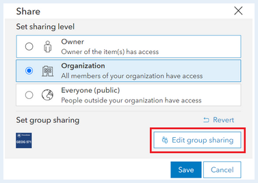
- Go to the metadata page for your story
- On the right side click the button 'Share'
- Set the share level to 'Organization' and Set the group settings to the course’s group by clicking 'Edit Group Sharing.' make sure there is a check mark next to the course’s group.
Deliverable:
When you have finished compiling your StoryMap for this assignment and your StoryMap has been 'Published', save the URL for your StoryMap.
The URL for your StoryMap should look something like this:
- https://storymaps.arcgis.com/stories/223f1885402c44626ad614e5b844c2b4
To submit the URL for your StoryMap exercise, return to the Lesson 6: Cultural Landscapes module in Canvas and look for the Lesson 6 StoryMap Exercise dropbox. The dropbox has instructions for submitting the assignment.