Welcome to Exercise 5: Puzzling Out Relative Time.
Back in exercise 4, you learned to tell which side of a rock was pointing up when the rock was deposited. If that side is now pointing down, then the rock has been turned over. Much earlier in the course, you learned that sometimes rocks are broken by faults, with one side pushed over the other side, or one side sliding down across the other side as they are pulled apart, or one side sliding past the other side. And, you saw that sometimes rocks are bent into folds without breaking. Furthermore, you saw that sometimes erosion occurs, removing rocks from the surface, and that later more rocks might be added on top of an erosion surface. Over a lot of time, many of these things can happen--rocks might be deposited, folded, broken by pull-apart forces, eroded, buried, broken by slide-past forces, and more. Each of these steps leaves its signature on the rocks.
When Dr. Alley was a student, the professors hauled him and a bunch of classmates out to Utah, gave them a map showing the landscape but not the rocks, told them that if they walked "that way" they would soon walk onto the map, and assigned them to figure out what the rocks were, which were older and younger, which were broken or folded or eroded or buried, and which events happened in which order. Success meant a good grade; failure... Anyway, we can't take you out and drop you in the sage and scorpions, so we give you a chance to think about these things from the comfort of your computer chair. So, give it a try. You have until the due date to work on this but remember, you only have one opportunity to submit your answers so be careful to proof your work before you hit the submit button. And please, do not forget to submit your answers. It will NOT automatically submit for you!
One of the great tasks of geologists is putting things in order to tell the story. These rocks were deposited, and then they were tilted, and then they were faulted, and.... Much of the argument on the age of the earth hinges on things such as this: a single catastrophe cannot, by non-miraculous means, produce the amazing complexity observed in many settings. We describe some of this with the Grand Canyon, but it is useful for you to have the experience of how it is done.
The diagrams show various layers of rocks under the surface of the earth, as you might view them in a cliff. Your mission is to tell the story of the rocks in the second diagram. You can learn how by viewing the first diagram below. To view it, click on the triangular “play” button—the animation has a narration, so turn up your speaker. In this first animated diagram, all of the rock units are sedimentary, they were deposited more-or-less horizontally (as are all sedimentary rock units—mass wasting flattens out steep but loose piles), and then things happened. The history is, from oldest event (1) to youngest event (8):
1. Rock z was deposited
2. Rock y was deposited
3. Rock x was deposited
4. These rocks were tilted
5. Erosion produced unconformity t
6. Rock w was deposited
7. Rock v was deposited
8. Fault u broke all of the rocks
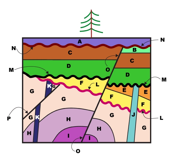
Now, you tell the story of the following diagram. It is a little more complicated. Note that the different features have letters on them (A through O). Rock layers A through I are sedimentary, and you may assume that they were deposited nearly horizontally and have not been turned upside-down (we would show you some upside-down footprints or something if the rocks had been flipped over). Features J and K are igneous rocks of the sort that can be intruded into other rocks (that is, melted rock can be squirted into a crack in older rock before freezing, forming features like J and K). Don’t confuse intrusive rock J, on the right, with sedimentary layer I, on the bottom—for some reason, a few people have browsers that make the fonts look similar. The wavy surfaces L, M, and N are unconformities, erosional surfaces that once were at the surface of the earth. Surfaces O and P are faults - breaks in the rocks along which motion has occurred during earthquakes. If an igneous rock, a fault, or an unconformity is truncated by (ends at) an unconformity, you may assume that the truncated feature once extended farther, and was eroded when the unconformity was formed. You also may assume that intrusions and faults are straight and continuous when formed—if you happened to see a bend or break in an intrusion or fault, you would infer that the intrusion or fault formed and was then bent or broken, and if you happened to see a straight, continuous intrusion or fault, you would assume that it had not been bent or broken after formation. (Originally-bent intrusions and faults exist, and there are ways to recognize them, but we don't want to get too complicated here—originally-broken ones are not known.)
The author came up with an 18-point history, but you only have to make 5 interpretations here. There really is a correct, unique answer for each of the questions, so if you think an ambiguity exists, have another look. (There are a couple of features on the diagram that cannot be ordered exactly—ambiguity is sometimes part of science—but we made sure not to ask you about those!) Remember the common-sense rules: sedimentary rocks are nearly horizontal and flat when deposited, most erosion surfaces are nearly horizontal and flat, a rock must be present before it can be cut by an intrusion or fault or before it can be eroded at an unconformity, and unless they are turned upside-down, older sediments are below younger ones.