The NSDI Framework Introduction and Reference (FGDC, 1997) envisions the hydrography theme in this way:
Framework hydrography data include surface water features such as lakes and ponds, streams and rivers, canals, oceans, and shorelines. Each of these features has the attributes of a name and feature identification code. Centerlines and polygons encode the positions of these features. For feature identification codes, many federal and state agencies use the Reach schedule developed by the U.S. Environmental Protection Agency (EPA).
Many hydrography data users need complete information about connectivity of the hydrography network and the direction in which the water flows encoded in the data. To meet these needs, additional elements representing flows of water and connections between features may be included in framework data (p. 20).
Identification
FGDC had the National Hydrography Dataset (NHD) in mind when they wrote this description. NHD combines the vector features of Digital Line Graph (DLG) hydrography with the EPA’s Reach files. Reaches are segments of surface water that share similar hydrologic characteristics. Reaches are of three types: transport, coastline, and waterbody. DLG lines features represent the transport and coastline types; polygon features are used to represent waterbodies. Every reach segment in the NHD is assigned a unique reach code, along with a host of other hydrological attributes including stream flow direction (which is encoded in the digitizing order of nodes that make up each segment), network connectivity, and feature names, among others. Because the order of reach codes are sequential from reach to reach, point-source data (such as a pollutant spill) can be geocoded to the affected reach. Used in this way, reaches comprise a linear referencing system comparable to postal addresses along streets (USGS, 2002).
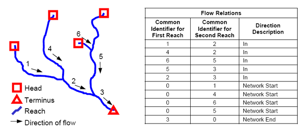
| Common Identifier for First Reach | Common Identifier for Second Reach | Direction Description |
|---|---|---|
| 1 | 2 | In |
| 4 | 2 | In |
| 6 | 5 | In |
| 5 | 3 | In |
| 2 | 3 | In |
| 0 | 1 | Network Start |
| 0 | 4 | Network Start |
| 0 | 6 | Network Start |
| 0 | 5 | Network Start |
| 3 | 0 | Network End |
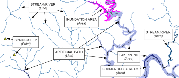
NHD parses the U.S. surface drainage network into four hierarchical categories of units: 21 Regions, 222 Subregions, 352 Accounting units, and 2150 Cataloging units (also called Watersheds). Features can exist at multiple levels of the hierarchy, though they might not be represented in the same way. For example, while it might make the most sense to represent a given stream as a polygon features at the Watershed level, it may be more aptly represented as a line feature at the Region or Subregion level. NHD supports this by allowing multiple features to share the same reach codes. Another distinctive feature of NHD is artificial flowlines--centerline features that represent paths of water flow through polygon features such as standing water bodies. NHD is complex because it is designed to support sophisticated hydrologic modeling tasks, including point-source pollution modeling, flood potential, bridge construction, among others (Ralston, 2004).
NHD are available at three levels of detail (scale): medium (1:100,000, which is available for the entire U.S.), high (1:24,000, production of which is underway, “according to the availability of matching resources from NHD partners” (USGS, 2002, p. 2), and local (larger scales such as 1:5,000), which "is being developed where partners and data exist" for select areas (USGS, 2006c; USGS, 2009; USGS 2013).
Spatial Reference Information
NHD coordinates are decimal degrees referenced to the NAD 83 horizontal datum.
Distribution
Try This!
Download and view an extract from the National Hydrography Dataset
- Visit the USGS's National Map Download site.
- Navigate the map to zoom in on your area of interest.
- Confirm that "Current Extent" is selected in the menu above the map. This specifies the area on the map for which you want to find data.
- Expand the "Hydrography (NHD) and Watersheds (WBD)" section in the left-hand menu and check the box next to any dataset you'd like to download. (If given the option, specify to download the dataset in shapefile format.) If you were working in ArcGIS, you could choose the File Geodatabase option. Ralston (2004, p.187) observes that NHD "is precisely the type of information that could benefit from an integrated data model in an object relational database."
- Click the "Find Products" Button and use the links provided in the search results to show the footprint of each dataset on the map and to download your preferred dataset.
- A ZIP archive (.zip) will be created that you can save to your hard disk (e.g., "n45w100.zip"). Proceed to save the data file to your computer. The download process will take several seconds, depending upon your Internet download rate.
- After you retrieve your data set open Global Mapper and navigate to where you saved the ZIP archive.
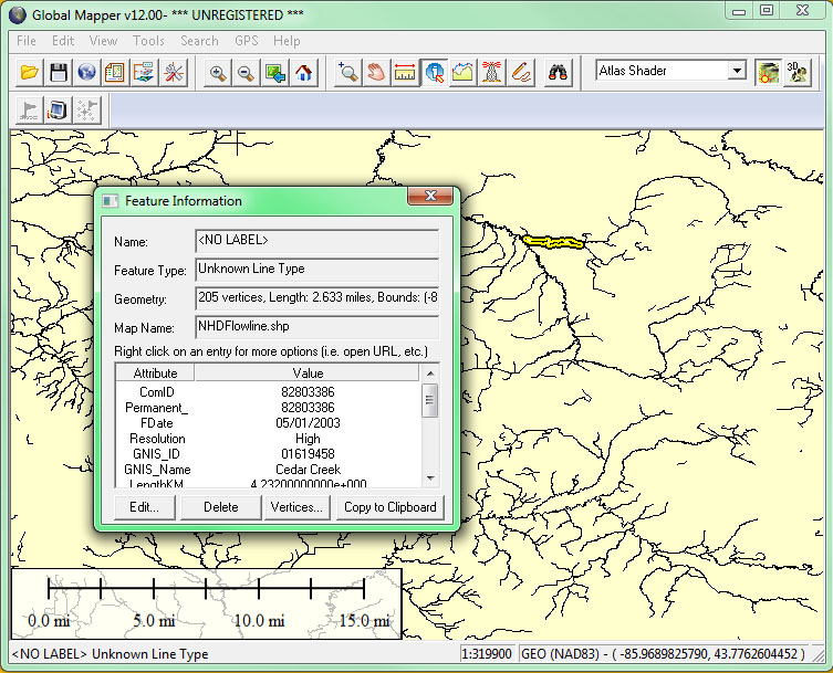
Double-click on the .zip file name. The data should display -- the software can read the data even in its compressed .zip form. - Use the Feature Info Tool pointer tool (the icon that looks like a blue-filled circle with an "i" in it) to reveal attributes of the reaches. In the example below, I have highlighted a flowline associated with Cedar Creek in western Michigan.