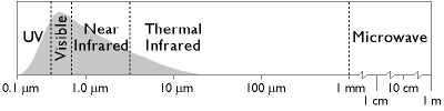
The remote sensing systems you've studied so far are sensitive to the visible, near-infrared, and thermal infrared bands of the electromagnetic spectrum, wavelengths at which the magnitude of solar radiation is greatest. IKONOS, AVHRR, and the Landsat MSS, TM, and ETM+ instruments are all passive sensors that only measure radiation emitted by other objects.
There are two main shortcomings to passive sensing of the visible and infrared bands. First, clouds interfere with both incoming and outgoing radiation at these wavelengths. Secondly, reflected visible and near-infrared radiation can only be measured during daylight hours. This is why the AVHRR sensor only produces visible and near-infrared imagery of the entire Earth once a day, although it is capable of two daily scans.
7.6.1 Microwave Data
Longwave radiation, or microwaves, are made up of wavelengths between about one millimeter and one meter. Microwaves can penetrate clouds, but the sun and Earth emit so little longwave radiation that it can't be measured easily from space. Active remote sensing systems solve this problem. Active sensors like those aboard the European Space Agency's ERS satellites, the Japanese JERS satellites, and the Canadian Radarsat, among others, transmit pulses of long wave radiation, then measure the intensity and travel time of those pulses after they are reflected back to space from the Earth's surface. Microwave sensing is unaffected by cloud cover, and can operate day or night. Both image data and elevation data can be produced by microwave sensing, as you will discover in the sections on imaging radar and radar altimetry that follow.
7.6.2 Imaging Radar
One example of active remote sensing that everyone has heard of is radar, which stands for Radio Detection And Ranging. Radar was developed as an air defense system during World War II and is now the primary remote sensing system air traffic controllers use to track the 40,000 daily aircraft takeoffs and landings in the United States. Radar antennas alternately transmit and receive pulses of microwave energy. Since both the magnitude of energy transmitted and its velocity (the speed of light) are known, radar systems are able to record either the intensity or the round-trip distance traveled by pulses reflected back to the sensor. Systems that record pulse intensity are called imaging radars.
In addition to its indispensable role in navigation, radar is also an important source of raster image data about the Earth's surface. Radar images look the way they do because of the different ways that objects reflect microwave energy. In general, rough-textured objects reflect more energy back to the sensor than smooth objects. Smooth objects, such as water bodies, are highly reflective, but unless they are perpendicular to the direction of the incoming pulse, the reflected energy all bounces off at an angle and never return to the sensor. Rough surfaces, such as vegetated agricultural fields, tend to scatter the pulse in many directions, increasing the chance that some back scatter will return to the sensor.
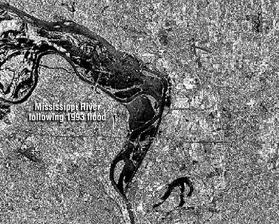
The imaging radar aboard the European Resource Satellite (ERS-1) produced the data used to create the image shown above. The smooth surface of the flooded Mississippi River deflected the radio signal away from the sensor, while the surrounding rougher-textured land cover reflected larger portions of the radar pulse. The lighter an object appears in the image, the more energy it reflected. Imaging radar can be used to monitor flood extents regardless of weather conditions. Passive instruments like Landsat MSS and TM that are sensitive only to shorter wavelengths are useless as long as cloud-covered skies prevail.
Practice Quiz
Registered Penn State students should return now take the self-assessment quiz about Visible and Infrared Imagery.
You may take practice quizzes as many times as you wish. They are not scored and do not affect your grade in any way.