There are a number of sources for satellite imagery, and the choice of which imagery you would need is dependent upon the context of the problem that you wish to solve. It is impossible to give you an in-depth survey of all of the available sensors and their data because of the sheer number of sensors in orbit. Instead, in the next section, we explore examples of remotely sensed image data produced by measuring electromagnetic energy in the visible, near-infrared, and thermal infrared bands.
7.5.1 IKONOS
When the Russian space agency first began selling its space surveillance imagery in 1994, a new company called Space Imaging, Inc. was chartered in the United States. Recognizing that high-resolution images were then available commercially from competing foreign sources, the U.S. government authorized private firms under its jurisdiction to produce and market remotely sensed data at spatial resolutions as high as one meter. By 1999, after a failed first attempt, Space Imaging successfully launched its IKONOS I satellite into an orbital path that circles the Earth 640 km above the surface, from pole to pole, crossing the equator at the same time every day. Such an orbit is called a sun synchronous polar orbit, in contrast with the geosynchronous orbit of communications and some weather satellites that remain over the same point on the Earth's surface at all times.
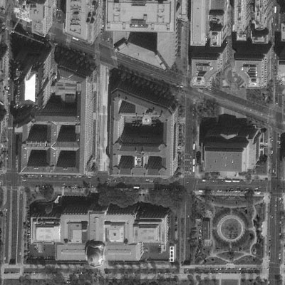
IKONOS' panchromatic sensor records reflectances in the visible band at a spatial resolution of one meter, and a bit depth of eleven bits per pixel. The expanded bit depth enables the sensor to record reflectances more precisely, and allows technicians to filter out atmospheric haze more effectively than is possible with 8-bit imagery. Archived, unrectified, panchromatic IKONOS imagery within the U.S. is available for as little as $7 per square kilometer, but new orthorectified imagery costs $28 per square kilometer and up.
The previous paragraph highlighted the one-meter panchromatic (pan) data produced by the IKONOS satellite sensor. Pan data is not all that IKONOS produces, however. It is a multispectral sensor that records reflectances within four other (narrower) bands, including the blue, green, and red wavelengths of the visible spectrum, and the near-infrared band. The range(s) of wavelengths that a sensor is able to detect is called its spectral sensitivity.
| Spectral Sensitivity | Spatial Resolution |
|---|---|
| 0.45 - 0.90 µm (panchromatic) | 1m |
| 0.45 - 0.52 µm (visible blue) | 4m |
| 0.51 - 0.60 µm (visible green) | 4m |
| 0.63 - 0.70 µm (visible red) | 4m |
| 0.76 - 0,85 µm (near IR) | 4m |
Credit: Pennsylvania State University.
A competing firm called ORBIMAGE acquired Space Imaging in early 2006, after ORBIMAGE secured a half-billion dollar contract with the National Geospatial-Intelligence Agency. The merged companies are now called GeoEye.
7.5.2 Landsat TM and ETM
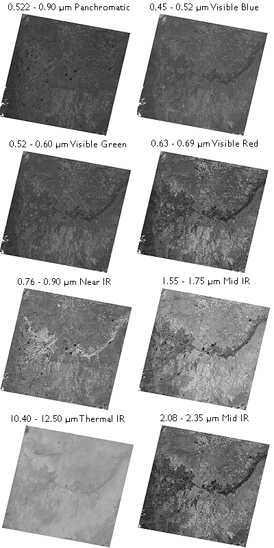
As NASA prepared to launch Landsat 4 in 1982, a new sensing system was added called Thematic Mapper (TM). TM was a new and improved version of Landsat Multispectral Scanner (MSS) that featured higher spatial resolution (30 meters in most channels) and expanded spectral sensitivity (seven bands, including visible blue, visible green, visible red, near-infrared, two mid-infrared, and thermal infrared wavelengths). An Enhanced Thematic Mapper Plus (ETM+) sensor, which includes an eighth (panchromatic) band with a spatial resolution of 15 meters, was onboard Landsat 7 when it successfully launched in 1999.
The spectral sensitivities of the TM and ETM+ sensors are attuned to both the spectral response characteristics of the phenomena that the sensors are designed to monitor, as well as to the windows within which electromagnetic energy are able to penetrate the atmosphere. The following table outlines some of the phenomena revealed by each of the wavelengths bands, phenomena that are much less evident in panchromatic image data alone.
| Band | Phenomena revealed |
|---|---|
| 0.45 - 0.52 µm (visible blue) | Shorelines and water depths (these wavelengths penetrate water) |
| 0.52 - 0.60 µm (visible green) | Plant types and vigor (peak vegetation reflects these wavelengths strongly) |
| 0.63 -0.69 µm (visible red) | Photosynthetic activity (plants absorb these wavelengths during photosynthesis) |
| 0.76 - 0.90 µm (near IR) | Plant vigor (healthy plant tissue reflects these wavelengths strongly) |
| 1.55 - 1.75 µm (mid IR) | Plant water stress, soil moisture, rock types, cloud cover vs. snow |
| 10.40 - 12.50 µm (thermal IR) | Relative amounts of heat, soil moisture |
| 2.08 - 2.35 µm (mid IR) | Plant water stress, mineral and rock types |
Phenomena revealed by different bands of Lndsat TM/ETM data.
Table Credit: USGS
Until 1984, Landsat data were distributed by the U.S. federal government (originally by the USGS's EROS Data Center, later by NOAA). Data produced by Landsat missions 1 through 4 are still available for sale from EROS. With the Land Remote Sensing Commercialization Act of 1984, however, the U.S. Congress privatized the Landsat program, transferring responsibility for construction and launch of Landsat 5, and for distribution of the data it produced, to a firm called EOSAT.
Dissatisfied with the prohibitive costs of unsubsidized data (as much as $4,400 for a single 185 km by 170 km scene), users prompted Congress to pass the Land Remote Sensing Policy Act of 1992. The new legislation returned responsibility for the Landsat program to the U.S. government. Data produced by Landsat 7 is distributed by USGS at a cost to users of $600 per scene (about 2 cents per square kilometer). Scenes that include data gaps caused by a "scan line corrector" failure are sold for $250; $275 for scenes in which gaps are filled with earlier data.
7.5.3 AVHRR
AVHRR sensors have been onboard sixteen satellites maintained by the National Oceanic and Atmospheric Administration (NOAA) since 1979 (TIROS-N, NOAA-6 through NOAA-15). The data the sensors produce are widely used for large-area studies of vegetation, soil moisture, snow cover, fire susceptibility, and floods, among other things.
AVHRR sensors measure electromagnetic energy within five spectral bands, including visible red, near infrared, and three thermal infrared. As we discovered earlier, the visible red and near-infrared bands are particularly useful for large-area vegetation monitoring through the calculation of NDVI (see 2.2.2 for review of the concept NDVI).
| Spectral Sensitivity | Spatial Resolution |
|---|---|
| 0.58 - 0.68 µm (visible red) | 1-4 km* |
| 0.725 - 1.10 µm (near IR) | 1-4 km* |
| 3.55 - 3.93 µm (thermal IR) | 1-4 km* |
| 10.3 - 11.3 µm (thermal IR) | 1-4 km* |
| 11.5 - 12.5 µm (thermal IR) | 1-4 km* |
Wavelengths are expressed in micrometers (millionths of a meter). Spatial resolution is expressed in kilometers (thousands of meters). *Spatial resolution of AVHRR data varies from 1 km to 16 km. Processed data consist of uniform 1 km or 4 km grids.
Credit: NASA
The NOAA satellites that carry AVHRR sensors trace sun-synchronous polar orbits at altitudes of about 833 km. Traveling at ground velocities of over 6.5 kilometers per second, the satellites orbit the Earth 14 times daily (every 102 minutes), crossing over the same locations along the equator at the same times every day. As it orbits, the AVHRR sensor sweeps a scan head along a 110°-wide arc beneath the satellite, taking many measurements every second. (The back and forth sweeping motion of the scan head is said to resemble a whisk broom.) The arc corresponds to a ground swath of about 2400 km. Because the scan head traverses so wide an arc, its instantaneous field of view (IFOV: the ground area covered by a single pixel) varies greatly. Directly beneath the satellite, the IFOV is about 1 km square. Near the edge of the swath, however, the IFOV expands to over 16 square kilometers. To achieve uniform resolution, the distorted IFOVs near the edges of the swath must be resampled to a 1 km grid (resampling is discussed later in this chapter). The AVHRR sensor is capable of producing daily global coverage in the visible band, and twice daily coverage in the thermal IR band.