So far, you've read that remote sensing systems measure electromagnetic radiation, and that they record measurements in the form of raster image data. The resolution of remotely sensed image data varies in several ways. As you recall, resolution is the least detectable difference in a measurement. In this context, four of the most important kinds of measurement for which resolution is a consideration are spectral, radiometric, spatial, and temporal resolution.
7.3.1 Spectral Resolution
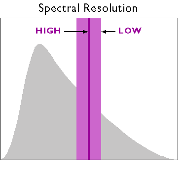
First, there is spectral resolution, the ability of a sensor to detect small differences in wavelength. For example, panchromatic film is sensitive to a broad range of wavelengths but not to small wavelength differences. An object that reflects a lot of energy in the green portion of the visible band would be indistinguishable in a panchromatic photo from an object that reflected the same amount of energy in the red band, for instance. A sensing system with higher spectral resolution would make it easier to tell the two objects apart.
7.3.2 Spatial Resolution
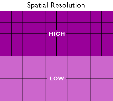
Spatial resolution refers to the coarseness or fineness of a raster grid. The grid cells in high resolution data, such as those produced by digital aerial imaging, or by the IKONOS sensor (described in detail below), correspond to ground areas as small as one square meter. Remotely sensed data, whose grid cells range from 15 to 80 meters on a side, such as the Landsat ETM+ and MSS sensors (also described below), are considered medium resolution. The cells in low resolution data, such as those produced by NOAA's AVHRR (Advanced Very High Resolution Radiometer) sensor (see below), are measured in kilometers.
The higher the spatial resolution of a digital image, the more detail it contains. Detail is valuable for some applications, but it is also costly. Although data compression techniques reduce storage requirements greatly, the storage and processing costs associated with high resolution satellite data often make medium and low resolution data preferable for analyses of extensive areas.
7.3.3 Radiometric Resolution
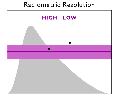
A third aspect of resolution is radiometric resolution, the measure of a sensor's ability to discriminate small differences in the magnitude of radiation within the ground area that corresponds to a single raster cell. The greater the bit depth (number of data bits per pixel) of the image that a sensor records, the higher its radiometric resolution is said to be. The AVHRR sensor, for example, stores 210 bits per pixel, meaning that the sensor is able to differentiate between 1023 intensity levels. In contrast, the Landsat sensors record the 28 bits per pixel (referred to as 8-bit), or just 256 intensity levels. Thus, although its spatial resolution is very coarse (~4 km), AVHRR takes its name from its high radiometric resolution.
7.3.4 Temporal Resolution
Temporal resolution describes the amount of time it takes for a sensor to revisit a given location at the same viewing angle during its orbit. The temporal resolution is dependent upon the sensor’s capabilities to adjust the sensor direction, swatch overlap, and the latitude at which the image is being taken. Temporal resolution is extremely important to consider when performing change analysis or for tracking temporal events. Aerial photography gives users the most flexibility when it comes to temporal resolution because flights are not limited by a continual orbital path.
Practice Quiz
Registered Penn State students should return now take the self-assessment quiz on the Nature of Image Data.
You may take practice quizzes as many times as you wish. They are not scored and do not affect your grade in any way.