Remote sensing is defined in Chapter 1 as data collected from a distance without visiting or interacting directly with the phenomena of interest. The distance between the object and observer can be large, for example imaging from the Hubble telescope, or rather small, as is the case in the use of microscopes for examining bacterial growth. In geography, the term remote sensing takes on a specific connotation dealing with space-borne and aerial imaging systems used to remotely sense electromagnetic radiation reflected and emitted from Earth’s surface. Space-borne remote sensing suggests the use of sensors attached to satellite systems continually orbiting around the Earth. In contrast, aerial imaging systems are typically sensors attached to aircraft and flown on demand, meaning that their data capture is not continuous.
Aerial photographs were first captured using balloons and pigeons, but with the invention of the airplane in 1903, a new method for aerial image acquisition was instated. The beginning of the modern remote sensing age began with the launch of the first satellite, Sputnik, in 1957. Since that point in time, numerous satellites have been launched carrying sensors, instruments for capturing electromagnetic energy emitted and reflected by objects on the Earth's surface. While early remote sensing was based on photographs, most of today’s remote sensing uses such sensors. Figure 7.1 below shows the launch dates of some of the more common remote sensing sensors. Later in this chapter, we will describe their specific uses in more detail.
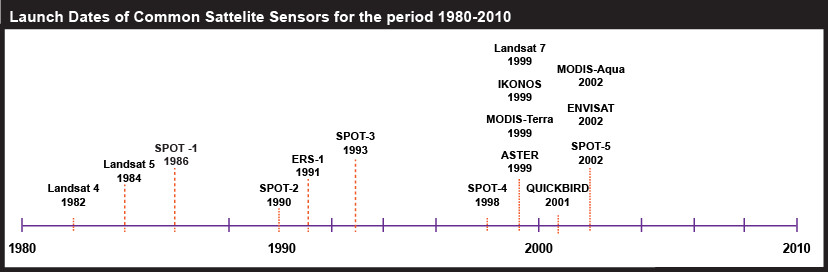
| Year | Satellite |
|---|---|
| 1982 | Landsat-4 |
| 1984 | Landsat-5 |
| 1986 | SPOT-1 |
| 1990 | SPOT-2 |
| 1991 | ERS-1 |
| 1993 | SPOT-3 |
| 1998 | SPOT-4 |
| 1999 | Landsat-7 |
| 1999 | IKONOS |
| 1999 | MODIS-Terra |
| 1999 | ASTER |
| 2001 | QUICKBIRD |
| 2002 | MODIS-Aqua |
| 2002 | ENVISAT |
| 2002 | SPOT-5 |
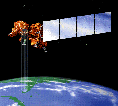
Remote sensing systems work in much the same way as a desktop scanner you may connect to your personal computer. A desktop scanner creates a digital image of a document by recording, pixel by pixel, the intensity of light reflected from the document. Color scanners may have three light sources and three sets of sensors, one each for the blue, green, and red wavelengths of visible light. Remotely sensed data, like the images produced by your desktop scanner, consist of reflectance values arrayed in rows and columns that make up raster grids. An example of a satellite used to scan the surface of the Earth to produce such raster images is provided in Figure 7.2.
Remote sensing is used to solve a host of problems across a wide variety of disciplines. For example, Landsat imagery is used to monitor plant health and foliar change. In contrast, imagery such as that produced by IKONOS is used for geospatial intelligence applications and monitoring urban infrastructure. Other satellites, such as AVHRR (Advanced High-Resolution Radiometer), are used to monitor the effects of global warming on vegetation patterns on a global scale. The MODIS (Moderate Resolution Imaging Spectroradiometer) Terra and Aqua sensors are designed to monitor atmospheric and oceanic composition in addition to the typical terrestrial applications. View animations of NASA’s MODIS satellite images over 2007 wildfires in Southern California.
Next, it is important to understand the basic terminology used to describe electromagnetic energy. Analysis of the reflectance of this energy can be used to characterize the Earth’s surface. You will see that digital remote sensing is like scanning a paper document with a desktop scanner, but more complicated, due to factors that include movement of both the Earth and the sensors and the atmosphere intervening between them. In the following section, we will learn how objects on the Earth's surface reflect and emit electromagnetic energy in ways that allow for the analysis of objects and phenomena on the Earth's surface.