The USGS developed one of the first land use/land cover classification systems designed specifically for use with remotely sensed imagery. The Anderson Land Use/Land Cover Classification system, named for the former Chief Geographer of the USGS who led the team that developed the system, consists of nine land cover categories (urban or built-up; agricultural; range; forest; water; wetland; barren; tundra; and perennial snow and ice), and 37 subcategories (for example, varieties of agricultural land include cropland and pasture; orchards, groves, vineyards, nurseries, and ornamental horticulture; confined feeding operations; and other agricultural land). Image analysts at the U. S. Geological Survey created the USGS Land Use and Land Cover (LULC) data by manually outlining and coding areas on air photos that appeared to have homogeneous land cover that corresponded to one of the Anderson classes.
The LULC data were compiled for use at 1:250,000 and 1:100,000 scales. Analysts drew outlines of land cover polygons onto vertical aerial photographs. Later, the outlines were transferred to transparent film georegistered with small-scale topographic base maps. The small map scales kept the task from taking too long and costing too much, but also forced analysts to generalize the land cover polygons quite a lot. The smallest man-made features encoded in the LULC data are four hectares (ten acres) in size, and at least 200 meters (660 feet) wide at their narrowest point. The smallest non-man-made features are sixteen hectares (40 acres) in size, with a minimum width of 400 meters (1320 feet). Smaller features were aggregated into larger ones. After the land cover polygons were drawn onto paper and georegistered with topographic base maps, they were digitized as vector features, and attributed with land cover codes. A rasterized version of the LULC data was produced later.
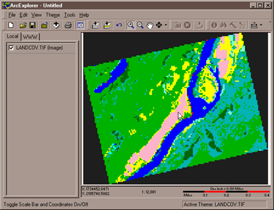
The successor to LULC is the USGS's National Land Cover Data (NLCD). Unlike LULC, which originated as a vector data set in which the smallest features are about ten acres in size, NLCD is a raster data set with a spatial resolution of 30 meters (i.e., pixels represent about 900 square meters on the ground) derived from Landsat TM imagery. The steps involved in producing the NLCD include preprocessing, classification, and accuracy assessment, each of which is described briefly below.
7.7.1 Preprocessing
The first version of NLCD--NLCD 92--was produced for subsets of ten federal regions that make up the conterminous United States. The primary source data were bands 3, 4, 5, and 7 (visible red, near-infrared, mid-infrared, and thermal infrared) of cloud-free Landsat TM scenes acquired during the spring and fall (when trees are mostly bare of leaves) of 1992. Selected scenes were geometrically and radiometrically corrected, then combined into sub-regional mosaics comprised of no more than 18 scenes. Mosaics were then projected to the same Albers Conic Equal Area projection (with standard parallels at 29.5° and 45.5° North Latitude, and central meridian at 96° West Longitude) based upon the NAD83 horizontal datum.
7.7.2 Image Classification
An unsupervised classification algorithm was applied to the preprocessed mosaics to generate 100 spectrally distinct pixel clusters. Using aerial photographs and other references, image analysts at USGS then assigned each cluster to one of the classes in a modified version of the Anderson classification scheme. Considerable interpretation was required, since not all functional classes have unique spectral response patterns.
| Level I Classes | Level II Classes | |
|---|---|---|
| Water | 11 | Open Water |
| 12 | Perennial Ice/Snow | |
| Developed | 21 | Low Intensity Residential |
| 22 | High Intensity Residential | |
| 23 | Commercial/ Industrial/Transportation | |
| Barren | 31 | Bare Rock/Sand/Clay |
| 32 | Quarries/ Strip Mines/Gravel Pits | |
| 33 | Transitional | |
| Forested Upland | 41 | Deciduous Forest |
| 42 | Evergreen Forest | |
| 43 | Mixed Forest | |
| Shrubland | 51 | Shrubland |
| Non-Natural Woody | 61 | Orchards/Vineyards/Other |
| Herbaceous Upland Natural/Semi-natural Vegetation | 71 | Grasslands/Herbaceous |
| Herbaceous Planted/Cultivated | 81 | Pasture/Hay |
| 82 | Row Crops | |
| 83 | Small Grains | |
| 84 | Fallow | |
| 85 | Urban/Recreational Grasses | |
| Wetlands | 91 | Woody Wetlands |
| 92 | Emergent Herbaceous Wetlands |
Table credit: USGS.
7.7.3 Accuracy Assessment
The USGS hired private sector vendors to assess the classification accuracy of the NLCD 92 by checking randomly sampled pixels against manually interpreted aerial photographs. Results from the first four completed regions suggested that the likelihood that a given pixel is correctly classified ranges from only 38 to 62 percent. Much of the classification error was found to occur among the Level II classes that make up the various Level I classes, and some classes were much more error-prone than others. USGS encourages users to aggregate the data into 3 x 3 or 5 x 5 pixel blocks (in other words, to decrease spatial resolution from 30 meters to 90 or 150 meters), or to aggregate the 21 Level II classes into the nine Level I classes.
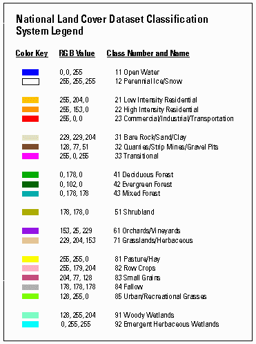
National Land Cover Dataset Classification System Legend:
| Color Key | RGB Value | Class Number and Name |
|---|---|---|
| Blue | 0, 0, 255 | 11 Open Water |
| White | 255, 255, 255 | 12 Perenniallce/Snow |
| Light Orange | 255, 204, 0 | 21 Low Intensity Residential |
| Orange | 255, 153, 0 | 22 High Intensity Residential |
| Red | 255, 0, 0 | 23 Commercial/Industrial/Transportation |
| Eggshell White | 229, 229, 204 | 31 Bare Rock/Sand/Clay |
| Brown | 128, 77, 51 | 32 Quarries/Strip Mines/Gravel Pits |
| Neon Pink | 255, 0, 255 | 33 Transitional |
| Green | 0, 178, 0 | 41 Deciduous Forest |
| Dark Green | 0, 102, 0 | 42 Evergreen Forest |
| Teal | 0, 178, 178 | 43 Mixed Forest |
| Olive Green | 178, 178, 0 | 51 Shurbland |
| Purple | 153, 25, 229 | 61 Orchards/Vineyards |
| Tan | 229, 204, 153 | 71 Grassland/Herbaceous |
| Yellow | 255, 255, 0 | 81 Pasture/Hay |
| Light Pink | 255, 179, 204 | 82 Row Crops |
| Pink | 204, 77, 128 | 83 Small Grains |
| Gray | 178, 178, 178 | 84 Fallow |
| Neon Green | 128, 255, 0 | 85 Urban/Recreational Grasses |
| Seafoam | 128, 255, 204 | 91 Woody Wetlands |
| Neon Teal | 0, 255, 255 | 92 Emergent Herbacious Wetlands |