Overview
Welcome to Geog 486! In this lesson, we will talk about the basics of map design, including how to customize your map to fit a specific audience, medium, and purpose. We will also introduce some topics that we will cover more in-depth later in the course, including visual variables, scale, and online map distribution. For this week’s lab activity, we will be making general-purpose basemaps in ArcGIS Pro. For those of you that haven’t used ArcGIS Pro before, this will be a good introduction to the software, and for all it will provide an opportunity to start thinking more deeply about the principles of cartographic design.
Throughout the lesson content, you will notice Student Reflection prompts. These prompts are opportunities for you to pause and reflect on what you have learned and how it relates to previous course content or your own personal or professional experience. Though not required, you are welcome to post responses to these prompts in the lesson discussion forum. You should post something to the lesson discussion each week, but you may choose to post a question/answer or comment about the lab instead.
Now, let's begin Lesson 1.
Learning Outcomes
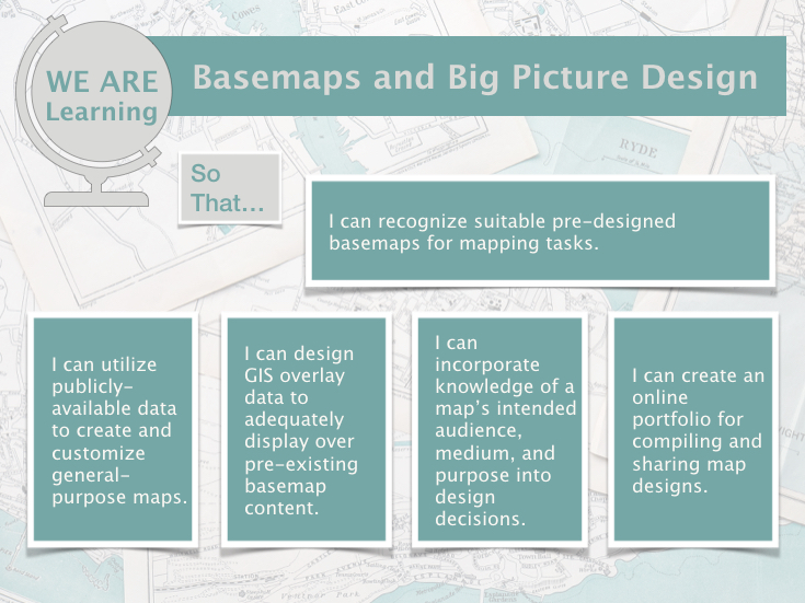
By the end of this lesson, you should be able to:
- recognize suitable pre-designed basemaps for mapping tasks;
- utilize publicly-available data to create and customize general-purpose maps;
- design GIS overlay data to adequately display over pre-existing basemap content;
- incorporate knowledge of a map’s intended audience, medium, and purpose into design decisions;
- create an online portfolio for compiling and sharing map designs.
Lesson Roadmap
|
Action |
Assignment | Directions |
|---|---|---|
| To Read |
In addition to reading all of the required materials here on the course website, before you begin working through this lesson, please read the following required readings:
Additional (recommended) readings are clearly noted throughout the lesson and can be pursued as your time and interest allows. |
The required reading material is available in the Lesson 1 module. |
| To Do |
|
|
Questions?
If you have questions, please feel free to post them to the Lesson 1 Discussion forum. While you are there, feel free to post your own responses if you, too, are able to help a classmate.