5.10 Looking at the Whole Cloud
Extra Credit Alert!
Announcing a new activity worth one point of extra credit for each lucky winner: Picture of the Week! Here is how to participate:
- You take a picture of some atmospheric phenomenon—a cloud, wind-blown dust, precipitation, haze, winds blowing different directions—anything that strikes you as interesting.
- Add a short description of the processes that you think are causing your observation. A Word file is a good format for submission.
- Use your name as the name of the file. Upload it to Picture of the Week Dropbox in this week's lesson module. To be eligible for the week, your picture must be submitted by 23:59 UT on Sunday of each week.
- I will be the sole judge of the weekly winners. A student can win up to three times.
- There will be a Picture of the Week dropbox each week through Lesson 11. Keep submitting entries!
Here is an example below:
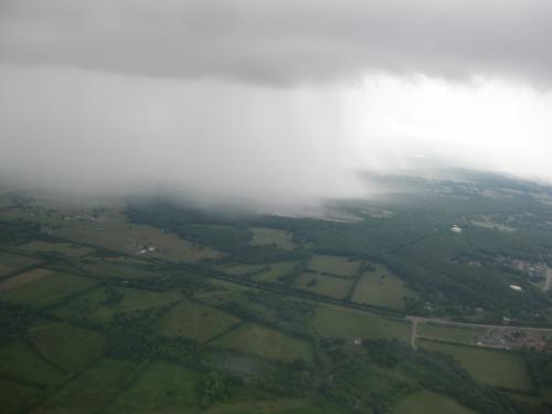
Heavy precipitation from a cumulonimbus cloud over Alabama, Summer 2013. This cumulus cloud rose to over 30,000 ft, about 9 km, and heavy afternoon rains fell under this cloud. This cloud is in the "mature" stage of development. This picture was taken from the NASA DC-8 aircraft, which was flying a few thousand feet above the ground in the cloud's inflow region.
Credit: W. Brune © Penn State is licensed under CC BY-NC-SA 4.0
Putting It All Together
We can put all of the processes from this lesson together to look at the lifecycle of a cloud:
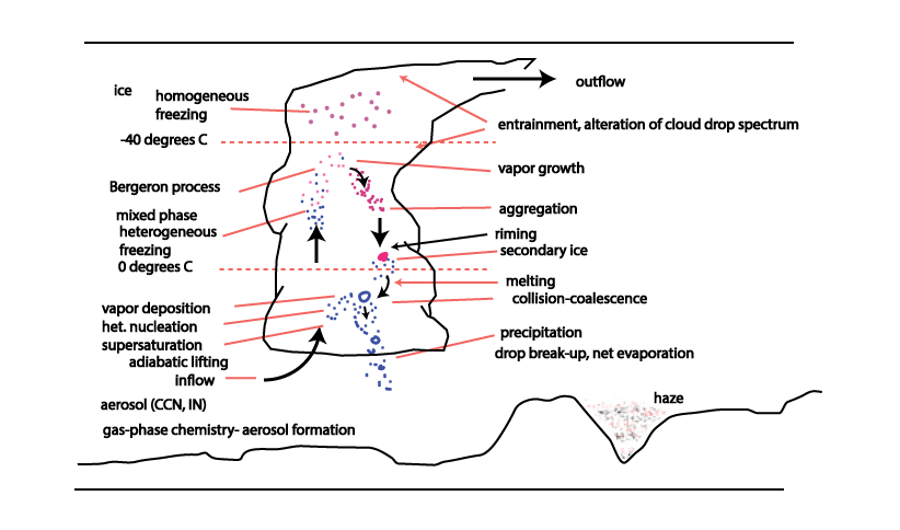
The lifecycle of a cloud. This schematic contains essentially all the processes that we have talked about in this lesson.
Credit: W. Brune © Penn State is licensed under CC BY-NC-SA 4.0
The following is a description of convection’s stages of development:
- Local perturbation in atmospheric density fields, sometimes driven by uneven surface heating or evaporation, starts relative vertical motion
- Stage 1: “Developing Stage” (also called Cumulus Stage)
- Updraft dominates center of cloud, cloud drops form and grow
- Release of latent heat provides the energy for vertical motion and growth
- Stage 2: “Mature Stage”
- Downdrafts form in addition to updrafts, causing gust fronts
- Cloud reaches height so that freezing occurs and precipitation develops
- Evaporation of precipitation drives downdrafts
- Stage 3: “Dissipating Stage”
- Downdrafts only
- Liquid water is removed by sedimentation/evaporation
The video below (2 min.) includes some great time-lapse video of clouds forming and disappearing (No audio). Check it out:
Spring Cloud Time Lapse
Credit: Harrison Rowntree. "Spring Cloud Time Lapse." YouTube. September 15, 2013.
Quiz 5-4: How precipitation forms.
- You can take Practice Quiz 5-4 as many times as you like.
- When you feel you are ready, take Quiz 5-4. You will be allowed to take this quiz only once. Good luck!