
Recall our discussion of the general circulation of the atmosphere from Lesson #1.
There we learned that the circulation of the atmosphere is driven by the contrast in surface heating between the equator and the poles. That contrast results from the difference between incoming short wave solar heating and outgoing loss from the surface through various modes of energy transport, including radiational heat loss as well as heat loss through convection and latent heat release through evaporation.
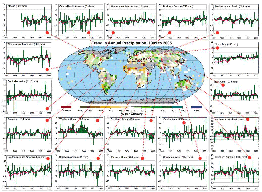
It, therefore, stands to reason that climate change — which in principle involves changing the balance between incoming and outgoing radiative loss via changes in the greenhouse effect — is likely to alter the circulation of the atmosphere itself, and thus, large-scale precipitation patterns. The observed changes in precipitation patterns are far noisier (very variable and difficult to interpret) than temperature changes, however. Regional effects related to topography (e.g., mountain ranges that force air upward leading to wet windward and dry leeward conditions) and ocean-atmosphere heating contrasts that drive regional circulation patterns, such as monsoons, etc., lead to very heterogeneous patterns of changes in rainfall, in comparison with the pattern of surface temperature changes.

We might expect certain reasonably simple patterns to emerge, nonetheless. As we shall see in a later lesson looking at climate change projections, climate models predict that atmospheric circulation cells and storm tracks migrate poleward, shifting patterns of rainfall between the equator and poles. The subtropics and middle latitudes tend to get drier, while the subpolar latitudes get wetter (primarily in winter). The equatorial region actually is predicted to get wetter, simply because the rising motion that occurs there squeezes out more rainfall from the warmer, moister lower atmosphere. If we average the observed precipitation changes in terms of trends in different latitudinal bands, we can see some evidence of the changes.
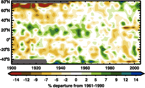
For example, we see that over time the high northern latitudes (60-80N) are getting wetter, while the subtropical and middle latitudes of the Northern Hemisphere are getting drier. However, there is a lot of variability from year to year, and from decade to decade, making it difficult to clearly discern whether the theoretically predicted changes are yet evident.
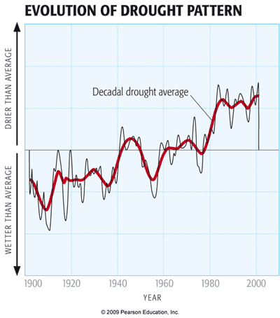
Drought, as we will see, does not simply follow rainfall changes. Rather, it reflects a combination of both rainfall and temperature influences. Decreased rainfall can lead to warmer ground temperatures, increased evaporation from the surface, decreased soil moisture, and thus drying.
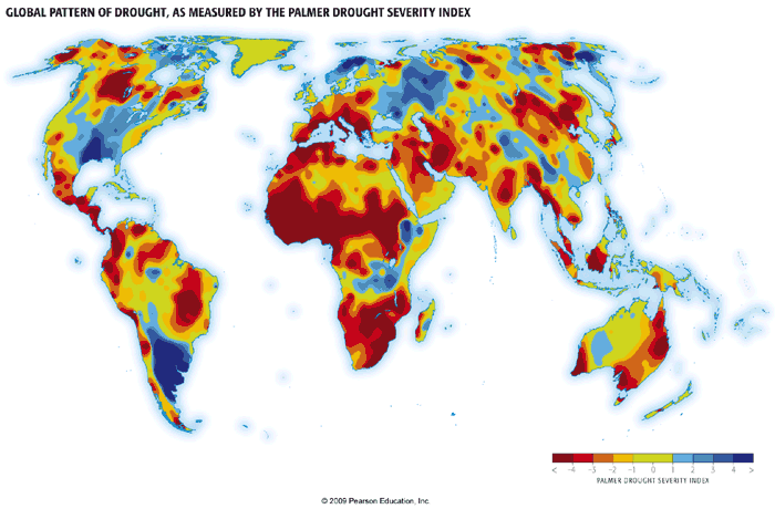
Like rainfall, regional patterns of drought are complicated and influenced by a number of different factors. However, the combination of shifting rainfall patterns and increased evaporation has led to very pronounced increases in drought in subtropical regions, and even in many tropical and subpolar regions, where rainfall shows little trend (as indicated in the earlier graphic) but warmer temperatures have led to decreased soil moisture. These broad trends are seen in measurements of the Palmer Drought Severity Index -- an index that combines the effects of changing rainfall and temperature to estimate soil moisture content; the more negative the index, the stronger the drought.
In the next lesson, we will assess evidence for changes in extreme weather events, such as heat waves, floods, tropical cyclone activity, etc. In the meantime, however, we are going to digress a bit and discuss the topic of how to analyze data for inferences into such matters as discerning whether or not trends are evident in particular data sets, and whether it is possible to establish a relationship between two or more different data sets.