Greater New Orleans
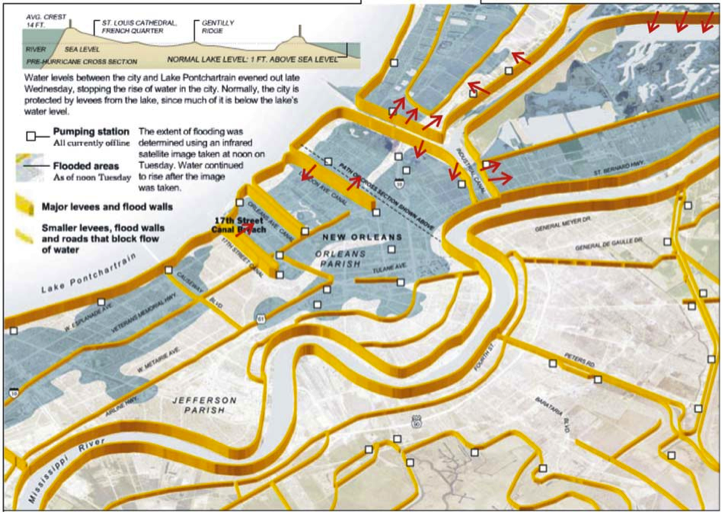
The city of New Orleans' expansion was partially driven by the need for space (to expand) and the unavailability of sufficient space above sea level. Driven partially by flood protection measures due to the Mississippi River and Tributaries Project, the city expanded into the former back-swamp north of its original footprint. Small-scale levees, termed drainage levees, were constructed on the South shore of Lake Pontchartrain and drainage canals were dredged so that floodwaters could be conveyed out to the lake. To facilitate drainage from an area that is shaped like a bowl (recall Digital Elevation map earlier), an elaborate system of pumping stations, in conjunction with the levees, had to be built. Despite these improvements, the city was still frequently flooded by hurricane-induced storm surge, including major floods in 1947 and 1965. These events, and particularly Hurricane Betsy in 1965, resulted in the inception of another federal project, where the Lake Pontchartrain levees were raised to the current elevation. But the lack of space to construct strong earthen levees, such as those that line up the Mississippi River banks, called for a hybrid construction method. This included the addition of sheet pile walls added atop the existing drainage canal levees, forming the foundation for the concrete floodwalls. These structures failed catastrophically during Hurricane Katrina. The figure below gives a typical cross-section of the city, stretching from the river on the left to the lake on the right.
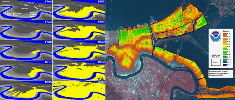
Was the catastrophic flooding from Hurricane Katrina due to false protection and unknown risk? To partially answer the above question, we examine city urbanization patterns with the city topography and flood depths from the widespread event that provided the only data point for flooding post-1965. Historically, and to accommodate the growing population of the city, settlement expanded from the crescent-shaped high ground that was organized along the natural levees of the Mississippi River into the former backswamp areas. This expansion would not have been possible without the development of cutting-edge pumping technologies coupled with an elaborate and challenging levee building construction. These technologies first enabled the swamps to be drained, promoted development to extend into these low areas, and helped keep the city drained during heavy rainfall. But, the modifications that took place post-1965 were proven to be the most vulnerable and were not really tested until decades later. While still not immune to flooding risks, areas above sea level in the original city plan were significantly less vulnerable and fared relatively well during Katrina. Recall the DEM at the beginning of the module, and now examine the figure below. From the figure to the left, it can be seen that New Orleans did not expand significantly into low-elevation areas until the late 19th century, exposing the population in the newly-settled areas to elevated flood risks. Up until this point, the settlement patterns of the city clearly followed smart building principles, where development was generally limited to the higher elevations of the natural levees and relic distributary ridges. False protection, afforded by the levees and an elaborate pumping system, produced peace of mind but without contingency or layered defense concept/approach, and resulted in catastrophic flooding when the levees failed.