
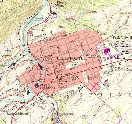
Topographic maps provide much more information than just showing the physical characteristics of the land. In this section of a USGS Topo Quad, not only are the land contours visible, but this map also shows the major roads leading into and out of Bellefonte, PA, the Bellefonte street system, the major structures present, individual residences, railroad tracks, power lines, and much more. Topo maps play a major part in siting electric transmission lines.
Why we need it
Topographic data shows the lay of the land, and topography is a critical criterion in the selection of a proposed route or alternate routes. By reviewing topographical data, siting planners and engineers can identify slope and stability issues, wetlands, stream crossings, etc., to select the most cost-effective route while minimizing impacts to the environment. This data also allows engineers to develop plans to mitigate the environmental impact during the construction phase. For example, in the United States, each stream crossing for temporary roads requires obtaining a state permit. In addition, erosion and sedimentation control plans are required for construction activities that will impact streams.
Where to find it
- Topographical maps are available for the most of the United States. Individual maps can be downloaded from the USGS The National Map US Topo site. On the left side menu, click on "Download Maps (Map Store)" to navigate to the interactive map where you can locate and download topographical maps.
- Digital Elevation Model (DEM) data can also be downloaded from the National Map. Landcover data can also be downloaded from that site.
Tell us about it!
Do you have any suggestions for additional data sources? Do you know of any international sources? Use the Discussion Forum share your suggestions with the class!