
Visual resources include such things as national parks, monuments and battlegrounds, Native American burial grounds, historical sites and buildings, cemeteries and even local neighborhoods, just to name a few.
An example of the visual impacts on National Park lands from proposed transmission lines follows, and taken from National Parks Conservation Association:
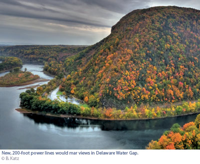
But views throughout much of the park unit could change substantially if a power company gets its way. Two energy companies—Public Service Electric & Gas (PSE&G) and PPL Electric Utilities—are proposing a serious upgrade to a smaller power line that predates the park, and winds its way through its southern half, crossing the river near the current visitor center. Eighty-foot towers that only occasionally rise above the canopy of maple, ash, and dogwood could soon be replaced by 200-foot towers that would dwarf them. A narrow right-of-way would expand to 300 feet to accommodate the two 500-kilovolt lines, which might require special lighting or bright orange balls for visibility. Asphalt roads would be constructed to provide constant access to what would become a main artery for coal- and nuclear power delivered to New York."
For obvious reasons, the power company’s preferred alternative is to simply traverse the corridor already established in the park—to cover the shortest distance between two points (see map), and to remove the need to purchase privately owned land or claim eminent domain."
Why we need it
The location of a transmission line can impair the line of sight to the visual resources mentioned, or in the instances of local neighborhoods can be a source of unsightly encroachment on neighborhood aesthetics. Transmission lines crossing over or near Federal lands requires a NEPA (National Environmental Policy Act) environmental impact analysis or assessment that includes a visual impact assessment on the Federal lands.
Where to find it
Tell us about it!
Do you have a suggestion or two for additional data sources? Do you know of any international sources? Use the Discussion Forum to share your suggestions with the class!