
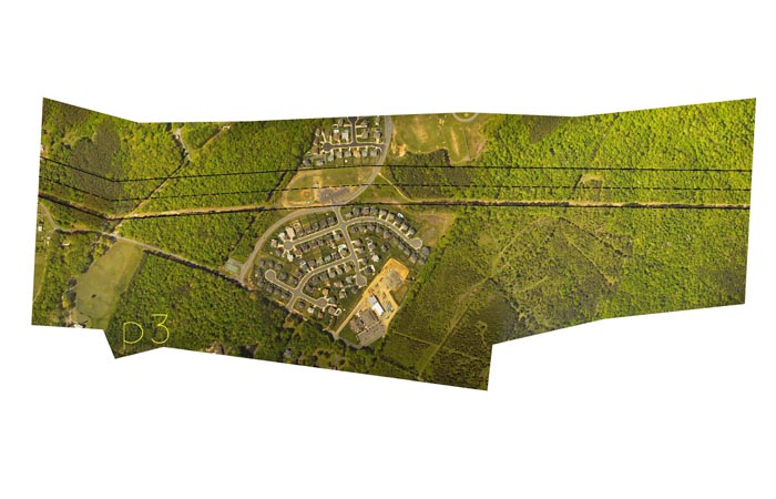
This aerial photo shows how Dominion Resources use aerial photography to overlay proposed transmission lines. It provides the transmission line siting team with a visual picture of where to position transmission lines to minimize the impact on people and the environment. There are times when the optimum route does have an impact, such as the corridor route depicted in the above aerial.

Why we need it
Aerial and satellite imagery give us a picture in time of what the landscape of the project areas looks like. This imagery provides much more detail than a topographical map. By overlaying planned routes on aerial images, siting planners can readily visualize obstacles that can hinder permitting and construction. For example, population density, structure density, wetlands, water bodies, forest land, agriculture operations, and existing transmission lines are easily identified through an analysis of the aerial imagery. In addition, by comparing current and historical imagery, siting planners can identify projected commercial and residential growth areas and plan alternate routes to circumvent them.
Where to find it
- The United States Department of Agriculture maintains the National Agriculture Imagery Program (NAIP). NAIP acquires aerial imagery during the agricultural growing seasons in the continental United States. A primary goal of the NAIP program is to make digital orthophotography available to governmental agencies and the public within a year of acquisition.
- Another source for aerial imagery is the USGS National Aerial Imagery Program.
- Most state and county governments make imagery available for use in GIS applications. For example, 2005 Illinois Digital Orthophoto Quarter Quadrangle data can be downloaded from the Illinois State Library. See "Individual State GIS Data" later in this lesson for a comprehensive list of available state GIS data.
Tell us about it!
Do you have a suggestion or two for additional data sources? Do you know of any international sources? Use the Discussion Forum to share your suggestions with the class!