Regarding the signals broadcast by the GLONASS satellites, the original objective was similar to the plan embraced by GPS, a system that would provide 100 meters accuracy with a deliberately degraded standard C/A signal and 10- to 20-meter accuracy with its P signals available exclusively to the military. However, that changed at the end of 2004, when the Federal Space Agency (FKA) announced a plan to provide access to the high-precision navigation data to all users whose foundation is a right-hand circular polarized code-based solution.
A receiver collecting signals from GPS, or from most other GNSS constellations, for that matter, collects a unique segment of the PRN code from each satellite. For example, a particular segment of the 37-week long P(Y) code is assigned to each GPS satellite; i.e., SV14 is so named because it broadcasts the fourteenth week of the P(Y) code. Also, each GPS satellite broadcasts its own completely unique segment of the C/A code.
Simultaneous
Souce: http://www.pocketgpsworld.com/howgpsworks.php
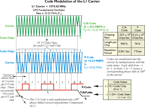
Even though the segments of the P(Y) code and the C/A code coming into a receiver on L1 are unique to their satellite or origin, they all arrive at the same frequency, 1575.42 MHz. The same is true of the P(Y) code that arrives on L2. They all arrive at the same frequency, 1227.60 MHz.
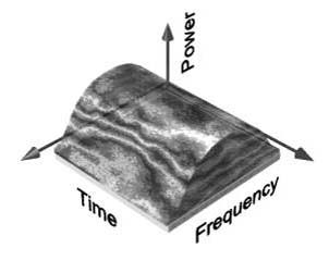
This approach is known as CDMA (Code Division Multiple Access). CDMA technology was originally developed by the military during World War II. Researchers were looking for ways of communicating that would be secure in the presence of jamming. CDMA does not use frequency channels or time slots. The technique is called multiple access because it serves many simultaneous users, and CDMA does this over the same frequency. As in GPS, CDMA usually involves a narrow band message multiplied by a wider bandwidth PRN (pseudorandom noise) signal. The increased bandwidth is wider than necessary to broadcast the data information and is called a spread spectrum signal. As you have read, these PRN codes are attached to the GPS carrier by changes in phase. Then all the users can receive the same frequency bands. To make this work, it is important that each of the PRN codes, C/A, P(Y), and all the others, have high autocorrelation and low cross-correlation properties. High autocorrelation promotes efficient de-spreading and recovery of the unique code coming from a particular satellite which includes matching it with the PRN code available for that satellite inside the receiver. Low cross-correlation means that the autocorrelation process for a particular satellite’s signal will not be interfered with by any of the other satellite’s signals that are coming in from the rest of the constellation at the same time. With CDMA, each code that comes from a satellite is broadcast on one of the three unique carrier frequencies, L1, L2, L5. There is a difference between the original scheme in the GLONASS system and the GPS. There's a difference between CDMA and FDMA.
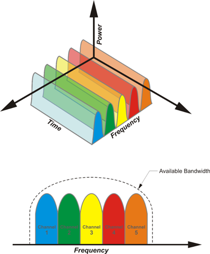
GLONASS used a different strategy from its beginnings. As shown in illustration, the satellites transmit L-band signals, and, unlike GPS, each code a GLONASS receiver collects from any one of the GLONASS satellites is exactly the same. Also, unlike GPS, each GLONASS satellite broadcasts its codes at its own unique assigned frequency. This is known as FDMA (Frequency Division Multiple Access). This ensures signal separation known as an improved Spectral Separation Coefficient (SSC). However, the system does require more complex hardware and software development. Unlike GPS, each code a GLONASS receiver collects from any one of the GLONASS satellites is exactly the same. However, each is at a different frequency. All GPS satellites use the same frequencies but different segments of code. All GLONASS satellites use the same codes but different frequencies.
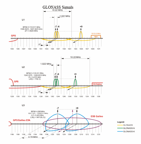
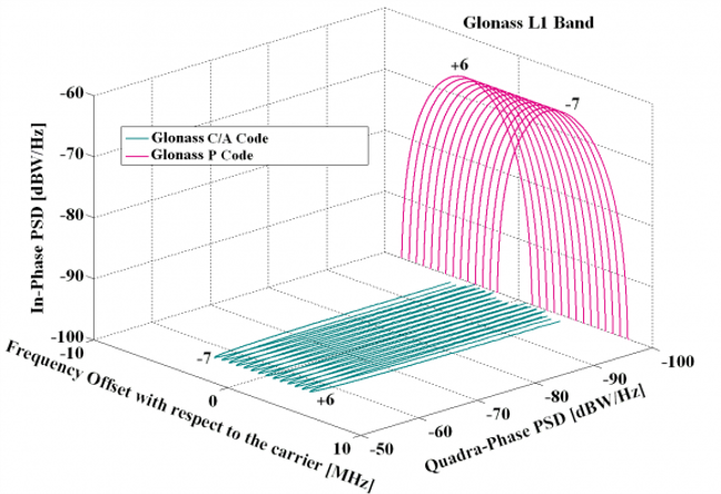
The three GLONASS L bands have a range of frequencies to assign to satellites. GLONASS uses carriers in three areas. The first is L1 (~1602 MHz), in which the separation between individual carriers is 0.5625 MHz; the range is between ~1598.0625 to ~1607.0625 MHz. The second is L2 (~1246 MHz), in which the separation between individual carriers is 0.4375 MHz; the range is between ~1242.9375 to ~1249.9375 MHz. The third is L3. This third civil signal on L3 is available on the K satellites and within a new frequency band (~1201 MHz) that includes 1201.743 to 1208.511 MHz and will overlap Galileo’s E5B signal. On L3, there will be a separation between individual carriers of 0.4375 kHz. However, within those ranges, there can be up to 25 channels of L-band signals; currently there are 16 channels on each to accommodate the available satellites.
Please note in the illustration, the -7 on the left and the +9 on the right for a total range from the center of 16. As mentioned, each channel is separated from the others by a ?F which is 0.5625 MHz on L1 and 0.4375MHz on L2. There could be up to 25 channels of L-band signals. This number is needed so that each satellite in the GLONASS constellation can have its own small frequency segment. Those are the little bumps that you see in the illustration. In other words, each GLONASS satellite broadcasts the same code, but each satellite gets its own frequencies.
The standard code chip lengths on the GLONASS L1 are 0.511MHz – 3135.03 L1 cycles/chip standard and 5.11 MHz precise – 313.503 L1 cycles/chip. On L2, they are 0.511MHz – 2438.36 L2 cycles/chip standard and 5.11 MHz precise – 243.836 L2 cycles/chip. Obviously, the faster one is the precise code. On L2, they are 0.511 MHz standard, and 511 MHz precise – the faster, of course, being the precise code. And there is, of course, this delineation between the precise and the standard service in GLONASS just as there is in GPS.
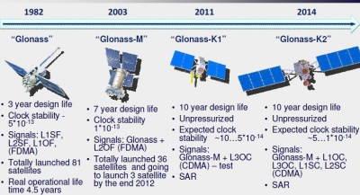
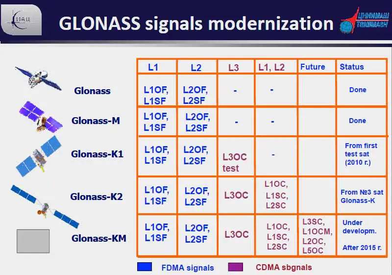
Signals transmitted by the different generations of GLONASS satellites.
OF 5 open-access FDMA
SF 5 special (military) FDMA
OC 5 open-access CDMA
OCM 5 open-access CDMA modernized.
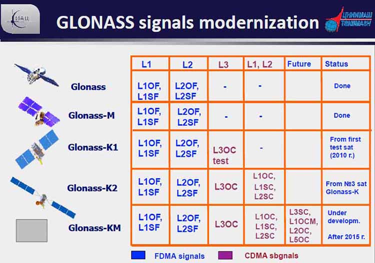
The head of the Russian GNSS Mission Control Center announced a plan in his February 20, 2008 presentation to the Munich Satellite Navigation Conference in Germany that CDMA signals would be tested in the GLONASS system beginning with the GLONASS-K generation of satellites. In fact, since its launch in February 2011, a Uragan K or GLONASS-K satellite has been broadcasting a CDMA signal on L3 which is centered on 1202.025 MHz along with an FDMA signal. There are more broadcasts of CDMA from GLONASS satellites coming, as you can see from the chart. As things develop further, the satellites in the GLONASS constellation will include GLONASS-M, GLONASS-K1, GLONASS-K2, and GLONASS-KM. The GLONASS-K2 satellites have a 10-year design life and carry a CDMA civil signal at L3 band in the 1205 MHz frequency. A modernized GLONASS-K satellite (GLONASS-KM) could transmit the legacy FDMA signals on L1 and L2 and CDMA signals on L1, L2, and L3. It could also transmit CDMA signals on the GPS L5 frequency at 1176.45 MHz. GNSS integrity information could also be broadcast in the third civil signal and global differential ephemeris and time corrections.
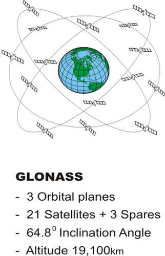
GLONASS Constellation
Source: GPS for Land Surveyor
Also, an alternative to the present three-plane, equally spaced satellite constellation, which would also require the legacy FDMA signals be switched off is also being studied. In other words, there may be some changes to the FDMA approach in the future. Recently, Russia agreed to alter the architecture a bit. In order to use only half as many bands, GLONASS will now assign the same frequency to satellites that are in the same orbital plane but are always on opposite sides of the earth. This will not only reduce the amount of the radio spectrum used by GLONASS; it may actually improve its broadcast ephemeris information. Utilizing so many frequencies makes it difficult to accommodate the wide variety of propagation rates and keep the ephemeris information sent to the receivers within good limits. There are a number of receiver manufacturers that have GPS/GLONASS receivers available, but the differences between FDMA and CDMA signals increase the technical difficulty and costs of such equipment. In the last few months of 2006, it was mentioned that GLONASS probably will be able to implement CDMA signals on the third frequency and at L1. This could make it easier for GPS and Galileo to be interoperable with GLONASS and will probably improve GLONASS’s commercial viability.
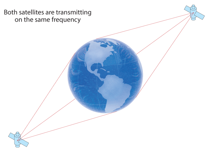
Both satellites are transmitting on the same frequency
Source: https://novatel.com/an-introduction-to-gnss/chapter-3-satellite-systems/...
Changes to FDMA. There may be some changes to the FDMA approach in the future. Recently Russia agreed to alter the architecture a bit. In order to use only half as many bands GLONASS will now assign the same frequency to satellites that are in the same orbital plane but are always on opposite sides of the Earth. This will not only reduce the amount of the radio spectrum used by GLONASS it may actually improve its broadcast ephemeris information. Utilizing so many frequencies makes it difficult to accommodate the wide variety of propagation rates and keep the ephemeris information sent to the receivers within good limits. There are a number of receiver manufacturers that have GPS/GLONASS receivers available but the differences between FDMA and CDMA signals increases the technical difficulty and costs of such equipment. In the last few months of 2006 it was mentioned that GLONASS probably will be able to implement CDMA signals on the third frequency and at L1. This could make it easier for GPS and GALILEO to be interoperable with GLONASS.