Click here to see a text description.
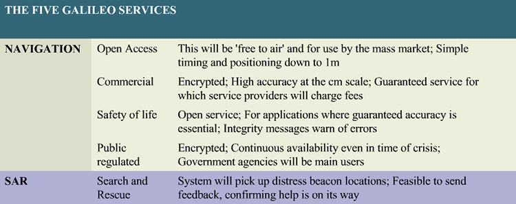
| Category | Type | Description |
| Navigation | Open Access | This will be 'free to air' and for use by the mass market; simple timing and positioning down to 1m |
| Navigation | Commercial | Encrypted; High accuracy at the cm scale; guaranteed service for which service providers will charge fees |
| Navigation | Safety of Life | Open service; for applications where guaranteed accuracy is essential; integrity messages warn of errors |
| Navigation | Public Regulated | Encrypted; continuous availability even in time of crisis; government agencies will be main users |
| SAR | Search and Rescue | The system will pick up distress beacon locations; feasible to send feedback, confirming help is on its way |
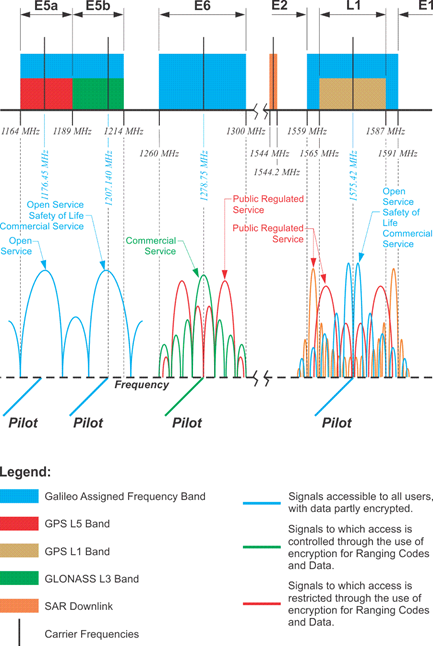
There are four Galileo signals. E5a, E5b, E6 and E2-L1-E1. E5a and E2-L1-E1 overlap the existing L1 and L5 GPS signals. The minimum power received from the Galileo signals is -152dBW more than double the power of the C/A code from GPS. There is a pilot, data-less as well as a data component in all the Galileo signals. They are broadcast in quadrature. The pilot signal enhances correlation and allows longer integration, as it does on L2C and L5 in GPS. The frequency standards in the Galileo satellites are rubidium and passive hydrogen masers.
Galileo has defined five levels of service that will be provided by the system. They include the Open Service (OS), which uses the basic signals and is quite similar to GPS and GLONASS. The OS is free and available for timing and positioning applications. The Safety of Life Service (SOL) is along the same line but provides increased guarantees including integrity monitoring, meaning that users are warned if there are signal problems. SOL will be a global service and will include both a critical level service and a less accurate non-critical level. Both SOL and OS are on the E5a, E5b and E2-L1-E1 carriers. Their availability on separate frequencies presents the ability to ameliorate the ionospheric bias.
The Public Regulated Service (PRS) is encrypted and is meant to assist public security and civil authorities. The PRS is under government control and provides significant jamming protection. PRS will be provided on E6 and E2-L1-E1. Likely applications will include emergency services, law enforcement, intelligence services, and customs.
The Search and Rescue Service (SAR) is intended to enhance space-based services and improve response time to distress beacons and alert messages. Galileo is another constellation in the COSPAS-SARSAT effort, already mentioned in the discussions of GPS and GLONASS. Transponders on the satellites transfer the distress signals broadcast by a user to centers that initiate rescue operations. In the Galileo application, the user also receives a notification that help has been dispatched.
The availability of the Open Service, Search and Rescue, and Public Regulated Service will coincide with Initial Operational Capability (IOC). Other services, such as the encrypted custom solutions and unique applications of the Commercial Service(CS), will follow as Full Operational Capability (FOC) is achieved.
The European Union has a different concept of satellite navigation than we are used to with GPS. They have divided their service into five different areas. This is to be a public asset as opposed to a primarily military system. The Galileo signals are known as L1, E5A and E5B. These signals will be compatible with the existing L1 GPS signal and the coming L5 signal. This is very good news. Galileo has defined five levels of service that will provide by the system. They are the open service or open access up here on top. As it says, be free to air and for use in the mass market. Timing and positioning down to about a meter. Very useful. Similar to GPS and GLONASS civil access codes. The safety of life is also an open service, meaning available, not encrypted. It includes integrity monitoring. Users are warned if there are signal problems. Example: If an ambulance were relying on this signal, there would be some guarantee of accuracy. If there were something wrong with the satellite's signals, it would be known immediately. The public regulated service, or PRS, is encrypted and meant to assist the public security and civil authorities. Government agencies will be the main users. SAR, the search and rescue service, is intended to enhance space-based services and improve response time to distress beacons and alert messages. The encrypted custom solutions for unique applications are provided in the commercial service. The commercial service is encrypted. It's a high-accuracy signal. It's centimeter scale and is a guaranteed service, for which providers will be charged fees. GPS users are used to it being for free. It appears that the Galileo system is planning a subscription of some type for the commercial signal that will be available from the Galileo satellites.
Interoperability Between GPS, GLONASS and GALILEO
Any discussion of interoperability between GPS and Galileo must consider the overlapping signals. It is helpful that the signals center on the same frequency if they are to be used in a combined fashion. For example, the third GLONASS civil reference signal on L3 that is available from the K satellites will be within a new frequency band that includes 1201.743-1208.511 MHz and will overlap Galileo’s E5b signal.
In the illustration, the Galileo signals are shown on the top and the GPS signals on the bottom. The Galileo satellites broadcast signals in several frequency ranges, including 1176-1207 MHz, near GPS L5. Galileo’s E5a signal is centered exactly at 1176.45 MHz, as is L5. The other overlapping signals can be seen at 1575.42 MHz, where Galileo’s L1 and the GPS Ll frequency are both centered. There, the GPS signal is based on the binary phase shift key (BPSK), and the Galileo signal is accomplished with the binary offset carrier (BOC) method. The compatibility of these methods can be seen graphically in the figure above (Figure 8.17 from the textbook). An important characteristic of BOC modulation is that the code’s greatest power density is at the edges that is at the nulls which, as it did with the M code on GPS, mitigates interference with the existing codes. In this case, not only will there not be interference between the codes on Galileo and GPS where they overlap, they can actually be used together. Galileo also has a signal E6 at 1278.75 MHz. As you can see, this band does not overlap any GPS frequency; however, it does happen to coincide with the band that Russia is considering for L3 on GLONASS.
E6 is part of the Radio Navigation Satellite Service (RNSS) allocation for Galileo. The Galileo signal E2-L1-E1 from 1559 to 1592 MHz is also part of the Radio Navigation Satellite Service. This signal is often known as simply L1. That is a convenient name since the GPS L1 is right there too. Spectral separation of GPS and Galileo L1 signals is accomplished by use of different modulation schemes. This strategy allows jamming of civil signals, if that should prove necessary, without affecting GPS M-code or the Galileo service. You can see the modulation method—BOC or BPSK, chipping rates, and data rates in the figure above. Also, please note the places where the carrier frequencies and frequency bands are common between GPS, GLONASS, and Galileo.
There are two signals on E6 with encrypted ranging codes, including one data-less channel that is only accessible to users who gain access through a given Commercial Service, CS, provider. And last, there are two signals, one in E6 band and one in E2–L1–E1, with encrypted ranging codes and data that are accessible to authorized users of the Public Regulated Service (PRS).
Frequency Coincidence
The fortuitous coincidences of frequencies between GPS and Galileo did not happen without discussion. As negotiations proceeded between the United States and the European Union, one of the most contentious issues arose just as the European Union was moving to get Galileo off the ground. They announced their intention to overlay Galileo’s Public Regulated Service (PRS) code on the U.S. Military’s M-code. The possibility that this would make it difficult for the DoD to jam the Galileo signal in wartime without also jamming the U.S. signal was considered. It became known as the M-code overlay issue. In June 2004, the United States and the European Union reached an agreement that ensured the Galileo’s signals would not harm the navigation warfare capabilities of the United States and the North Atlantic Treaty Organization (NATO).