GEOSC 10
Geology of the National Parks

Virtual Field Trips

PrintPrint

Join Dr. Alley and his team as they take you on "virtual tours" of National Parks and other locations that illustrate some of the key ideas and concepts being covered in Unit 11.

TECH NOTE - Click on the first thumbnail below to begin the slideshow. To proceed to the next image, move the mouse over the picture until the "next" and "previous" buttons appear ON the image or simply use the arrow keys.

Virtual Field Trip #1: Florissant Fossil Beds National Monument—Gnattily Dressed

A huge stump fossil of a redwood behind a fence
Florissant Fossil Beds National Monument—Gnattily Dressed Photos by National Park Service (indicated) or R. Alley; this is the “Big Stump” fossil redwood.
Sunset over the Colorado Rockies.
The Colorado Rockies Front Range is folded up, perhaps from shallow-subduction drag.
South Park viewed from Wilderson Pass.  Fields in front of the mountain range.
West of the Front Range are the parks, occupying the low parts of the folds. This is the real South Park, viewed from Wilkerson Pass.
South Park with colorful paintbrush in bloom.
The real South Park seems to be a nicer place than the one on TV. Here, paintbrush bloom in the mountain air.
Mountian range
Near the east edge of South Park, Colorado is Florissant Fossil Beds National Monument, one of the little-visited “gems” of the National Park Service.
Three images of fossil redwoods in the park.
Fossil redwoods are among the highlights at the park. These, including the “Big Stump” (bottom, Natl. Park Service picture) are along the Petrified Forest Loop Trail.
Fossils of a spider, bee, and a leaf, Florissant Fossil Beds.
“When the mountains are overthrown and the seas uplifted, the universe at Florissant flings itself against a gnat and preserves it.”-- Dr. Arthur C. Peale, Hayden Expedition Geologist, 1873 Fossil spider, bee, and leaf, Florissant (National Park Service Photos)
Fossil of sumac and hydrangea leaves.
Fossil sumac (left) and hydrangea (right) leaves from Florissant.
Graphic about evolution showing progression from a hoofed mammal  to a whale.
The previous slides showed fossils of things slightly different from living types. You really need to put the old and new next to each other to see the changes. Here and in the next picture are a couple of the many, many examples. Modern whales evolved from a primitive group of hoofed mammals (top) into species that were progressively more adapted to life in the water (moving downward). Although not every step along the evolutionary path was fossilized, many transitional forms are known, and the progression is clear.
Photographic collage sowing evolution of life on Earth through the last 600 million years.
(left) Photographic collage showing evolution of life on Earth through the last 600 million years. The oldest fossils are at the bottom and youngest at the top. The size of each time interval is proportional to its duration; Proterozoic extends beyond 600 million years. (right) Fossils from the Mid-Atlantic States show change through time, from late Cretaceous (late Mesozoic, 6) to Pliocene (late Cenozoic, 1). The shape of the posterior (rear) end of these clams becomes more rounded in the younger species, and the area where the two shells are held together (ligamental cavity) gets larger.

Virtual Field Trip #1: Florissant Fossil Beds National Monument-Gnattily Dressed
Click Here for Text Alternative of Virtual Field Trip #1

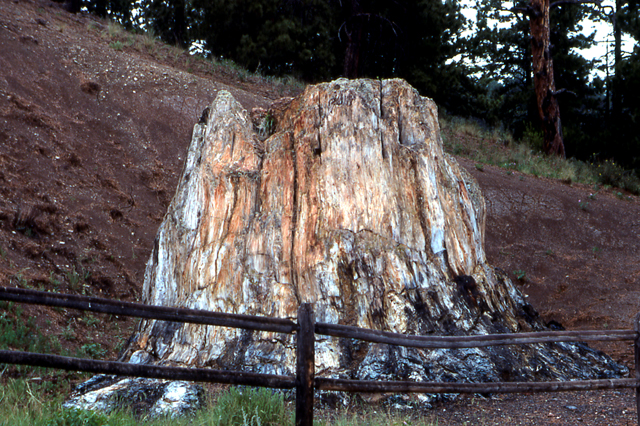
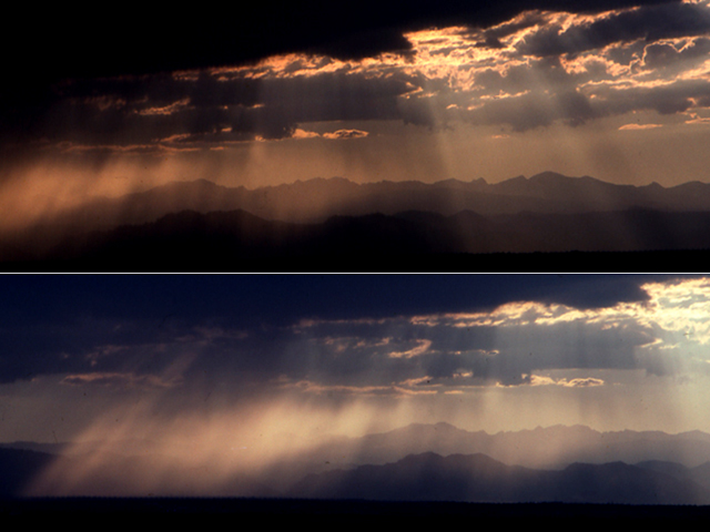
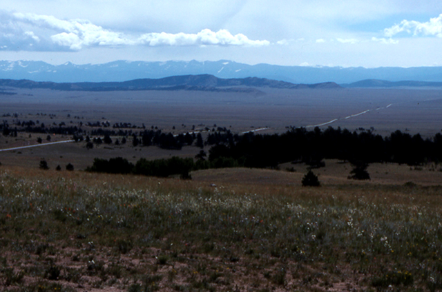
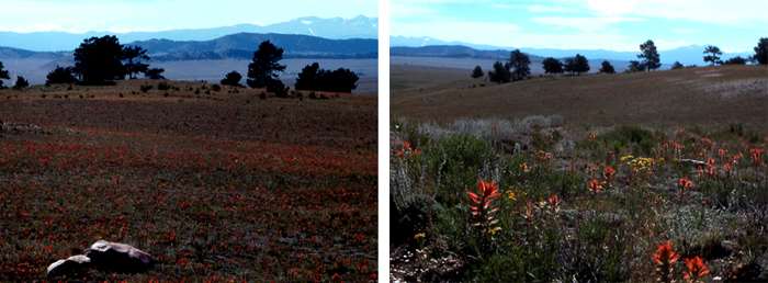
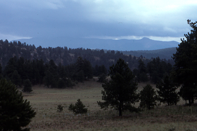
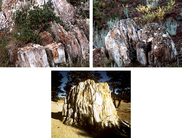
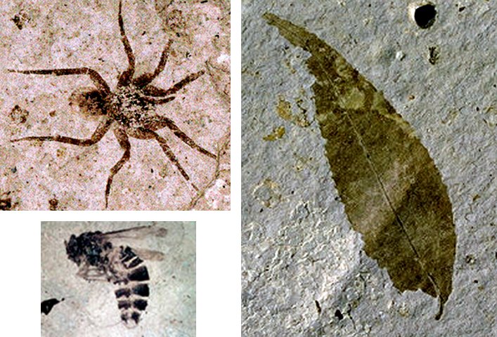
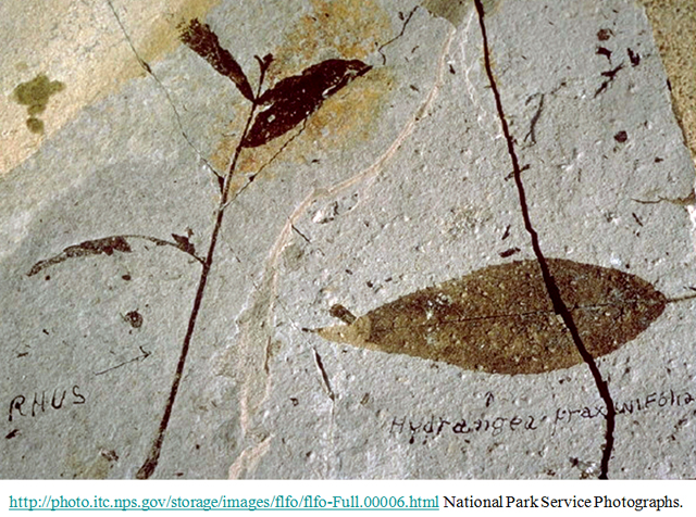
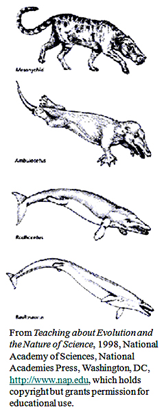
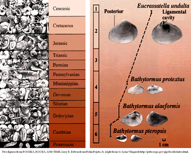
Image 1: A huge stump fossil of a redwood behind a fence. Florissant Fossil Beds National Monument—Gnattily Dressed Photos by National Park Service (indicated) or R. Alley; this is the “Big Stump” fossil redwood.

Image 2: Sunset over the Colorado Rockies. The Colorado Rockies Front Range is folded up, perhaps from shallow-subduction drag.

Image 3: South Park viewed from Wilderson Pass. Fields in front of the mountain range. West of the Front Range are the parks, occupying the low parts of the folds. This is the real South Park, viewed from Wilkerson Pass.

Image 4: South Park with colorful paintbrush in bloom. The real South Park seems to be a nicer place than the one on TV. Here, paintbrush bloom in the mountain air.

Image 5: Mountian range. Near the east edge of South Park, Colorado is Florissant Fossil Beds National Monument, one of the little-visited “gems” of the National Park Service.

Image 6: Three images of fossil redwood stumps in the park. Fossil redwoods are among the highlights at the park. These, including the “Big Stump” (bottom, Natl. Park Service picture) are along the Petrified Forest Loop Trail.

Image 7: Fossils of a spider, bee, and a leaf, Florissant Fossil Beds. When the mountains are overthrown and the seas uplifted, the universe at Florissant flings itself against a gnat and preserves it.”-- Dr. Arthur C. Peale, Hayden Expedition Geologist, 1873 Fossil spider, bee, and leaf, Florissant (National Park Service Photos)

Image 8: Fossil sumac and hydrangea leaves from Florissant.

Image 9: Graphic about evolution showing progression from a hoofed mammal to a whale.

The previous slides showed fossils of things slightly different from living types. You really need to put the old and new next to each other to see the changes. Here and in the next picture are a couple of the many, many examples. Modern whales evolved from a primitive group of hoofed mammals (top) into species that were progressively more adapted to life in the water (moving downward). Although not every step along the evolutionary path was fossilized, many transitional forms are known, and the progression is clear.

Image 10: Photographic collage sowing evolution of life on Earth through the last 600 million years. (left) Photographic collage showing evolution of life on Earth through the last 600 million years. The oldest fossils are at the bottom and youngest at the top. The size of each time interval is proportional to its duration; Proterozoic extends beyond 600 million years. (right) Fossils from the Mid-Atlantic States show change through time, from late Cretaceous (late Mesozoic, 6) to Pliocene (late Cenozoic, 1). The shape of the posterior (rear) end of these clams becomes more rounded in the younger species, and the area where the two shells are held together (ligamental cavity) gets larger.

Virtual Field Trip #2: Hardwoods—CAUSE and Park Paleontologist William Parker Explore the Petrified Forest

Petrified tree laying on the ground.
Hardwoods--CAUSE and Park Paleontologist William Parker Explore the Petrified Forest
Students hiking up a hill of dirt.  There are petrified trees laying on the ground at the crest of the hill
CAUSE students, led by Paleontologist William Parker, hiking in Black Forest section of Petrified Forest National Park.
A large petrified tree on the ground.  The trunk is split into about six pieces.
Many of the trees in the Petrified Forest were transported by rivers, losing their branches and often their bark before being buried and petrified. The conversion to stone was caused by the difference in chemistry between the trees themselves and groundwater in the volcanic-ash-rich soils, and is described in more detail in the Enrichment article in the textbook. This tree is Araucarioxylon arizonicum, an extinct relative of modern monkey-puzzle trees. Over 200 types of fossil plants are known to be in the park.
Pile of petrified wood includes one large chuck and many smaller pieces.
A pile of petrified wood, Petrified Forest National Park. Most of the wood in the park was carried and buried in great floods.
“Alpha Stump”.  It was petrified in place with it’s roots in the soil.
Paleontologist William Parker shows the CAUSE film crew the “Alpha Stump”, in the Black Forest section of Petrified Forest National Park. Unlike most of the fossil trees in the park, the “Alpha Stump” is in place, its roots in the soil where it grew about 210 million years ago.
Close up of little holes in a petrified tree.  They are insect burrows.
Insect burrows, probably the world’s oldest known fossil bee’s nest, in a petrified tree, Petrified Forest National Park.
Men kneeling on the ground excavating the armor plates of the late-Triassic (Mesozoic) giant armored amphibian, Koskinonodon.
Park Paleontologist William Parker (upper right) and ranger and UC-Berkeley graduate student Randall Irmis (left) excavating armor plates of late-Triassic (Mesozoic) giant-armored-amphibian Koskinonodon, also called Buettneria, see far right), Petrified Forest National Park.
Paleontologist showing a student a still-sharp fossil tooth.
Paleontologist Randall Irmis shows CAUSE student Irene Meglis a still-sharp fossil tooth, Petrified Forest National Park.
Close up of the dry ground with fossil bone fragments scattered on it.
Late Triassic (Mesozoic) fossil bone fragments, Petrified Forest. A simple field test--fossil bone sticks to your tongue, and fossil wood doesn’t.

Virtual Field Trip #2: Hardwoods—CAUSE and Park Paleontologist William Parker Explore the Petrified Forest
Click Here for Text Alternative for Virtual Field Trip #2

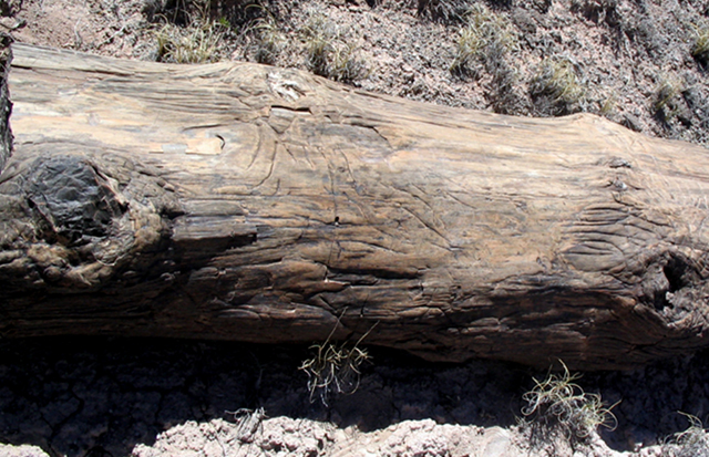
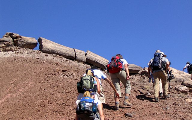
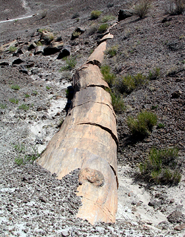
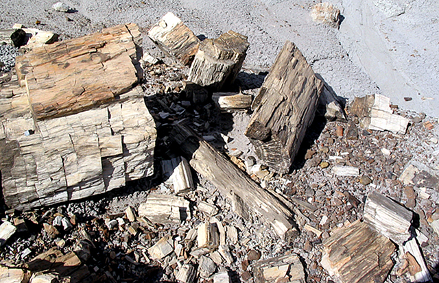
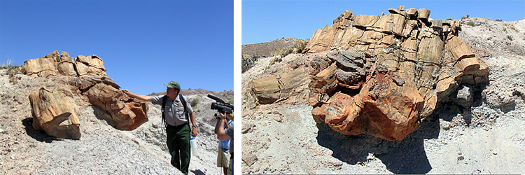
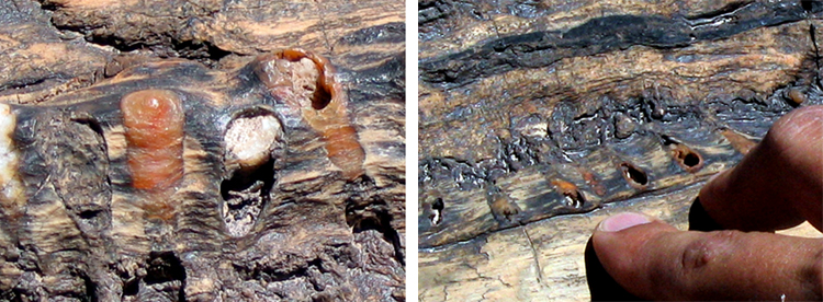
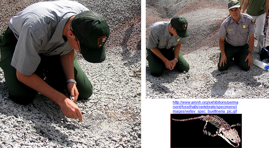
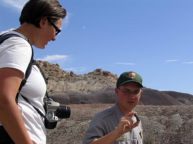
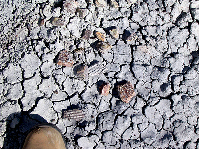
Image 1: Petrified tree laying on the ground. Hardwoods--CAUSE and Park Paleontologist William Parker Explore the Petrified Forest.

Image 2: Students hiking up a hill of dirt. There are petrified trees laying on the ground at the crest of the hill

Image 3: A large petrified tree on the ground. The trunk is split into about six pieces. Many of the trees in the Petrified Forest were transported by rivers, losing their branches and often their bark before being buried and petrified. The conversion to stone was caused by the difference in chemistry between the trees themselves and groundwater in the volcanic-ash-rich soils, and is described in more detail in the Enrichment article in the textbook. This tree is Araucarioxylon arizonicum an extinct relative of modern monkey-puzzle trees. Over 200 types of fossil plants are known to be in the park.

Image 4: Pile of petrified wood includes one large chuck and many smaller pieces. Most of the wood in the park was carried and buried in great floods.

Image 5: The “Alpha Stump”. Paleontologist William Parker shows the CAUSE film crew the “Alpha Stump”, in the Black Forest section of Petrified Forest National Park. Unlike most of the fossil trees in the park, the “Alpha Stump” is in place, its roots in the soil where it grew about 210 million years ago.

Image 6: Close up of little holes in a petrified tree. They are insect burrows and are probably the world’s oldest known fossil bee’s nest, in a petrified tree, Petrified Forest National Park.

Image 7: Park Paleontologist William Parker (upper right) and ranger and UC-Berkeley graduate student Randall Irmis (left) kneeling on the ground excavating armor plates of late-Triassic (Mesozoic) giant-armored-amphibian Koskinonodon also called Buettneria, Petrified Forest National Park.

Image 8: Paleontologist Randall Irmis shows CAUSE student Irene Meglis a still-sharp fossil tooth, Petrified Forest National Park.

Image 9: Close up of the dry ground with fossil bone fragments scattered on it. Late Triassic (Mesozoic) fossil bone fragments, Petrified Forest. A simple field test--fossil bone sticks to your tongue, and fossil wood doesn’t.

Virtual Field Trip #3: Dinosaurs: Where They Lived, and How They Died

The green river in Dinosaur National Monument.  The river is winding through the landscape.
The Green River in Dinosaur National Monument Photos by R. Alley or as indicated.
an outcropping of rock called the Morison Formation shows tipped up layers.
The river-channel and floodplain deposits of the Jurassic (mid-Mesozoic, about 150 million years old) Morrison Formation of Dinosaur National Monument, Colorado and Utah, were tipped up after being hardened.
The quarry at Dinosaur Ledge revealing dinosaur fossils.  The quarry is now under a man made structure.
The Quarry at Dinosaur Ledge. Eleven types of dinosaurs were washed onto this sand bar, perhaps in a great flood, buried, and their bones replaced by silica from groundwaters. The living types are quite different from their older relatives at Petrified Forest; a lot of evolutionary changes have occurred during the intervening 60 million years.
4 images from Dinosaur Ledge each showing fossils for various dinosaurs. There is a ranger standing next to one and the fossils dwarf her.
Four views of the Quarry at Dinosaur Ledge. Ranger in lower left for scale. Some of those dinosaurs were big!
a 49,000 year old impact Crater in Arizona.
The 49,000-year-old, 0.7-mile-across Barringer Impact Crater of Arizona was made by a rather small meteorite, roughly 150 feet (50 m) across--tiny compared to the one that killed the dinosaurs. Notice the road on the right for scale.
3 images.  1.Gravity field of Chicxulub impact crater 2.Core rock sample from Manson Iowa impact crater 3.Shocked quartz from impact crater.
Top Left: Gravity field of Chicxulub impact crater--the meteorite that killed the dinosaurs, on the Yucatan Peninsula. The crater is buried under younger rocks, but is quite evident here. The circular crater, between the pink arrows, is about 110 miles across. Top Right: Impact breccia. When a meteorite hits, it breaks rocks. This core is from the Manson, Iowa impact structure. Above: Shocked quartz from a meteorite impact. The bright colors are from the view between polarizing filters; the crossing lines are impact features. The grain is roughly 1/10 inch across.
2 images.  1. cosmic spherule from the mood . 2. Finger pointing to theK/T boundary bed in the stone making the end of the dinosaurs.
(Left) 1/250 in (0.1 mm) diameter cosmic spherule from the moon. Spherules such as this are well-known to result from impact deposits, and are found in the special K/T impact bed that marks the end of the dinosaurs. (Right) The finger is pointing to the K/T boundary bed marking the end of the dinosaurs, at Big Bend National Park.
Sediment core from offshore South Carolina showing the extinction across the K/T boundary.
This is a sediment core from offshore South Carolina, showing the extinction across the K/T boundary. The core is 40 cm long (about 16 inches). Richard D. Norris and the Ocean Drilling Project Leg 171B Scientific Party [http://www.usssp-iodp.org/Publications/Greatest_Hits/contributors.html#n] Photomicrographs by Brian Huber, Smithsonian Institution.

Virtual Field Trip #3: Dinosaurs: Where They Lived, and How They Died
Click Here for Text Alternative for Virtual Field Trip #3

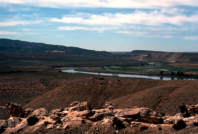
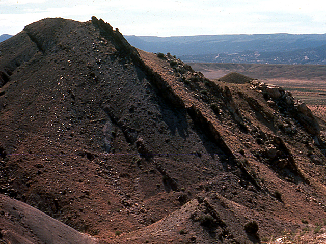
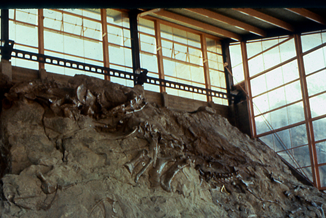
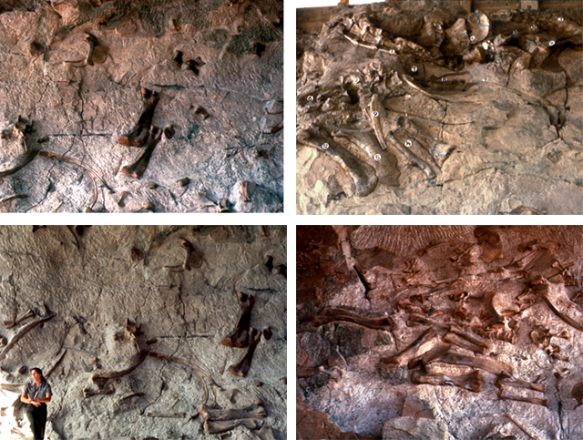
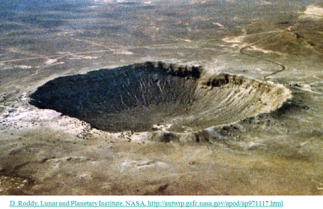
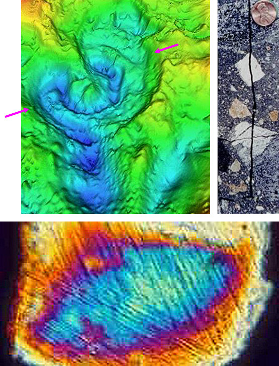
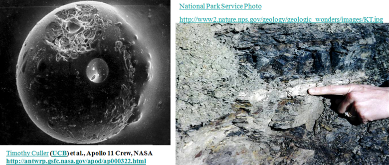
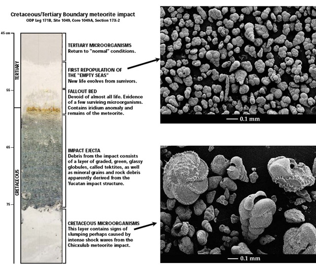
Image 1: The green river in Dinosaur National Monument. The river is winding through the landscape.

Image 2: an outcropping of rock called the Morison Formation shows tipped up layers. The river-channel and floodplain deposits of the Jurassic (mid-Mesozoic, about 150 million years old) Morrison Formation of Dinosaur National Monument, Colorado and Utah, were tipped up after being hardened.

Image 3: The quarry at Dinosaur Ledge revealing dinosaur fossils. The quarry is now under a man made structure. Eleven types of dinosaurs were washed onto this sand bar, perhaps in a great flood, buried, and their bones replaced by silica from groundwaters. The living types are quite different from their older relatives at Petrified Forest; a lot of evolutionary changes have occurred during the intervening 60 million years.

Image 4: 4 images from Dinosaur Ledge each showing fossils for various dinosaurs. There is a ranger standing next to one and the fossils dwarf her.

Image 5: A huge crater hole in Arizona. The 49,000-year-old, 0.7-mile-across Barringer Impact Crater of Arizona was made by a rather small meteorite, roughly 150 feet (50 m) across--tiny compared to the one that killed the dinosaurs. Notice the road on the right for scale.

Image 6: Three images. First is a gravity field of Chicxulub impact crater. The second is a core rock sample from Manson Iowa impact crater. The third is a shocked quartz from impact crater. First image: Gravity field of Chicxulub impact crater--the meteorite that killed the dinosaurs, on the Yucatan Peninsula. The crater is buried under younger rocks, but is quite evident here. The circular crater, between the pink arrows, is about 110 miles across. Second: Impact breccia. When a meteorite hits, it breaks rocks. This core is from the Manson, Iowa impact structure. Third: Shocked quartz from a meteorite impact. The bright colors are from the view between polarizing filters; the crossing lines are impact features. The grain is roughly 1/10 inch across.

Image 7: Two images. Left, a cosmic spherule from the moon . Right, a finger pointing to theK/T boundary bed in the stone making the end of the dinosaurs. (Left) 1/250 in (0.1 mm) diameter cosmic spherule from the moon. Spherules such as this are well-known to result from impact deposits, and are found in the special K/T impact bed that marks the end of the dinosaurs. (Right) The finger is pointing to the K/T boundary bed marking the end of the dinosaurs, at Big Bend National Park.

Image 8: This is a sediment core from offshore South Carolina, showing the extinction across the K/T boundary. The core is 40 cm long (about 16 inches). Richard D. Norris and the Ocean Drilling Project Leg 171B Scientific Party Photomicrographs by Brian Huber, Smithsonian Institution.

Virtual Field Trip #4: Dinosaurs: What They Stepped In

Close up of fossilized dinosaur foot prints from Dinosaur Ridge, CO.
Dinosaurs: What They Stepped In, A Virtual Tour of Dinosaur Ridge All pictures in this show are by Dr. Alley unless noted; some of the pictures here feature PSU graduate and noted scientist Matt Spencer.
2 images.  1.   Outcropping of rock that has been tipped up as the Rockies were formed.  2.  Fossilized dinosaur prints.
Dinosaur Ridge, just west of Denver, Colorado, is part of the Morrison Fossil Area National Natural Landmark as designated by the National Park Service. In the Cretaceous Period of the Mesozoic Era, about 100 million years ago, the area that is now the Ridge sat on the edge of the great Interior Seaway that extended eastward across Kansas, and connected the Gulf of Mexico with the Arctic Ocean. Sediments were deposited, hardened and then tipped up (picture at right) as the Rockies were raised just to the west. The dinosaur trackway (lower right) is the big attraction at the Ridge, although there is quite a bit more to see (including modern rabbits).
Dinosaur footprints.  An insert image shows one of the larger Iguanodon tracks with three kids hands in it for scale.
The dinosaur tracks really are spectacular. Various dinosaurs walked across the muddy surface, probably heading for a water hole. The little sign (bottom of the picture on the left) points to a three-toed Ornithomimus track. A picture of one of the larger Iguanodon tracks is shown in the inset, with kids’ hands for scale [from the Friends of Dinosaur Ridge website.]
various animal burrows from a shallow-water deposit near the dinosaur trackways.
Shown here are various animal burrows from a shallow-water deposit near the dinosaur trackways (with an interpretive sign to give you an idea of the scale). Modern muds similar to these are commonly burrowed by creatures looking for food or avoiding enemies. After a mud layer is deposited, it usually takes a while for the mud to stabilize, and critters to move in and burrow the heck out of the mud, as seen here.
2 pictures.  1.  Burrowed rock shows burrows from big and small animals.  2.  Heavily burrowed area buried by a moderately burrowed area.
A careful examination of the burrowed rocks from the previous picture shows that various critters were stirring the mud, including big ones (pink arrow) and little ones (blue arrow). Not every layer gets burrowed--if there is too little oxygen to support critters, or too little for critters to eat, or the layer is buried too rapidly, then burrowing may be restricted or absent. Here, the heavily burrowed layer (far right, green arrow) is buried under a moderately burrowed layer covered with ripple marks (the two red arrows in the upper left of the picture point along ripple-mark crests). In turn, the rippled layer was buried by another layer, which was buried by another… (see next slide).
close up of a rock showing a rippled layer covered up by another rippled layer.
The previous slide showed a burrowed layer buried beneath a rippled layer. Here, a different rippled layer was covered up by yet another rippled layer. (If you don’t see it, the next slide adds some annotations to help.)
close up of a rock showing a rippled layer covered up by another rippled layer.
In case you didn’t see the features in the previous slide, the solid pink line divides the layer on the bottom (which in the picture is to the upper right) from the layer on top (which in the picture is to the lower left). The crests of two ripples on the layer on the bottom are marked by the light-blue dot-dash lines, and the crests of five ripples on the layer on the top are marked by the dark-blue dotted lines.
Dinosaur tracks
As interesting as ripples and burrows may be, most people go to Dinosaur Ridge to see dinosaur tracks.
Three close ups of dinosaur tracks.
And, here are a few more pictures of the main trackway at Dinosaur Ridge. Many more trackways have been reported along the Front Range near Denver, and there are other tracks at Dinosaur Ridge in other rock layers (some coming later in this show), but this is the easiest one to see.
Two images.  1.  Dinosaur bone still in the rock.  2.  Layered rock with a orange layer in the middle.  Orange layer is volcanic ash.
Here are a couple more interesting items at Dinosaur Ridge. On the left is a dinosaur bone, still in the rock (lens cap for scale). Above, the yellow-orange-ish layer is volcanic ash, from a very large eruption nearby, which is sandwiched between more-ordinary sedimentary rocks.
Dr. Alley standing next to an edge-on  dinosaur track.
On the other side of Dinosaur Ridge from the “main” trackway seen earlier, you can see dinosaur tracks edge-on, such as this one indicated by Dr. Alley. The next picture includes an outline of the track.
Edge-on dinosaur track.  May need more explanation from Richard
“Artistic” rendition of dinosaur pulling foot out of mud after making track at Dinosaur Ridge, near Denver.
Another Edge-on dinosaur track.
Matt Spencer with dinosaur track, Dinosaur Ridge, near Denver. The next picture is a close-up with this track outlined.
close up of the previous edge on dinosaur track with the track outlined.
Close-up of previous picture, with dinosaur track outlined.
Previous image turned upside down showing what a dino footprint would look like if the rock turned upside down.
Dinosaurs didn’t walk on the ceiling. We just turned the previous picture upside-down, but if you found a track this way in nature, you should conclude that the rock has been turned upside-down.
Mountain goat.
A long and fascinating story links the dinosaurs tromping on mud when Denver was a coastal city, and this mountain goat looking down toward Denver from Mt. Evans 65 million years later. The giant meteorite that killed the dinosaurs left their “jobs” open to others, and evolution filled those jobs with the creatures we now know and enjoy.

Virtual Field Trip #4: Dinosaurs: What They Stepped In
Click Here for Text Alternative for Virtual Field Trip #4

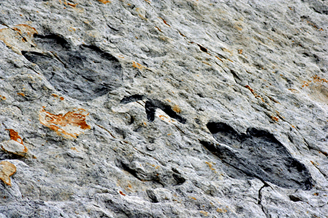
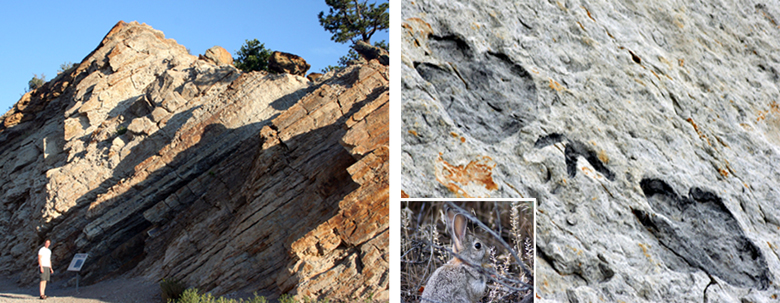
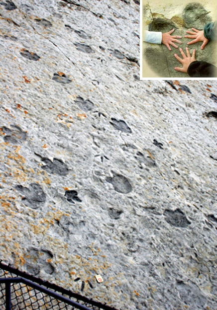
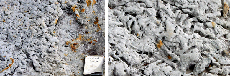
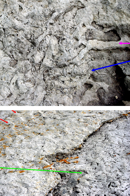
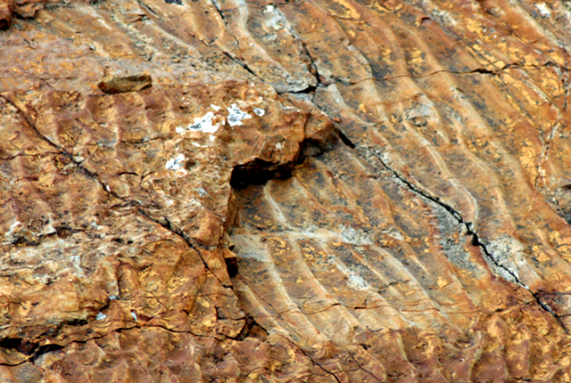
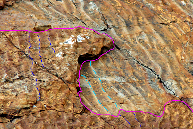
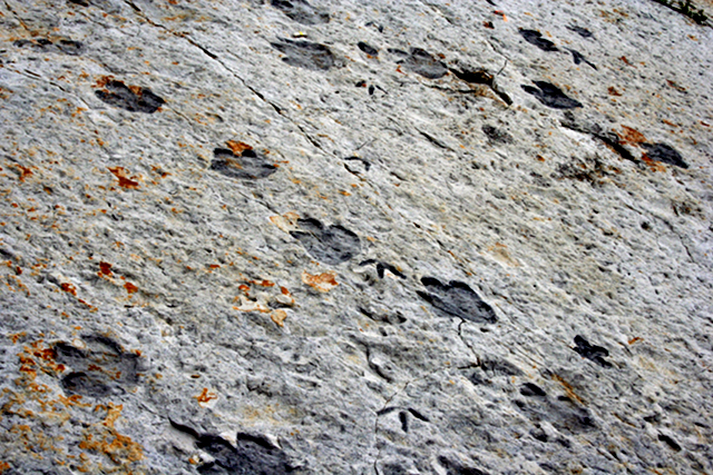
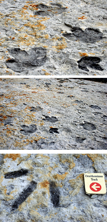
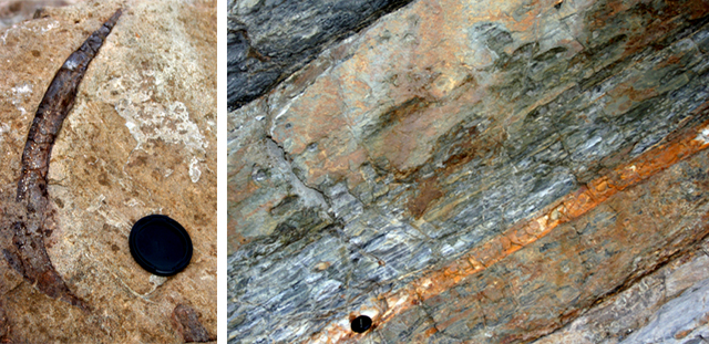
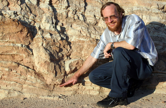
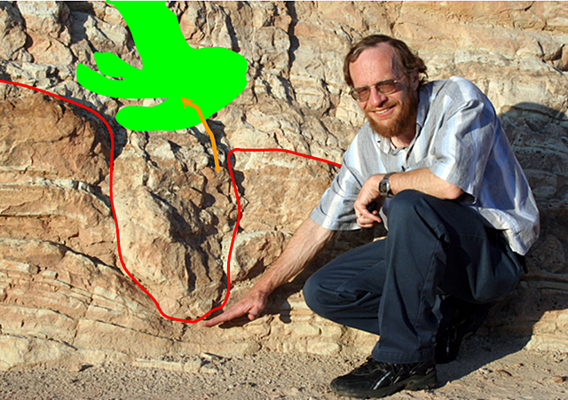
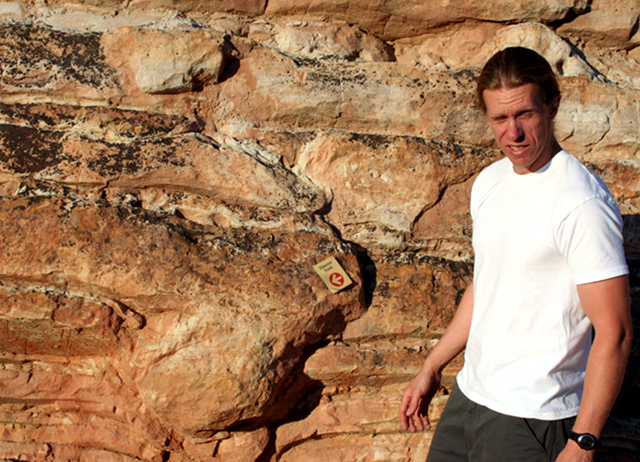
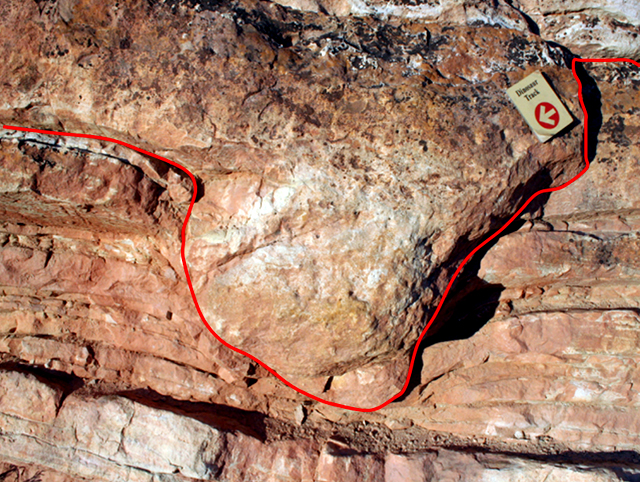
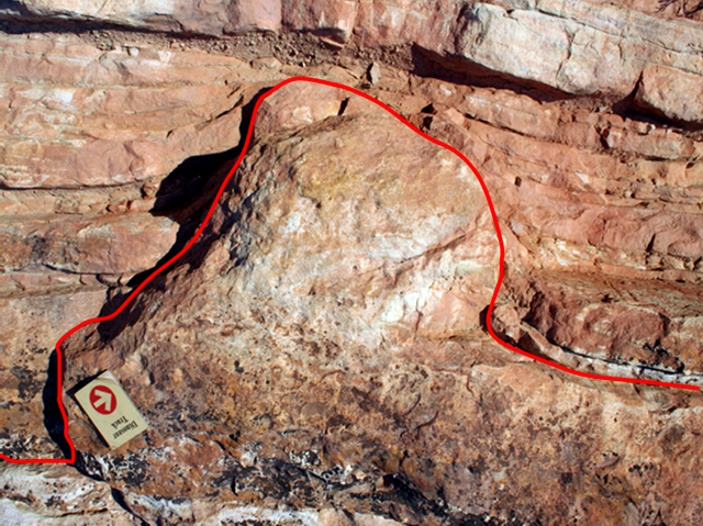
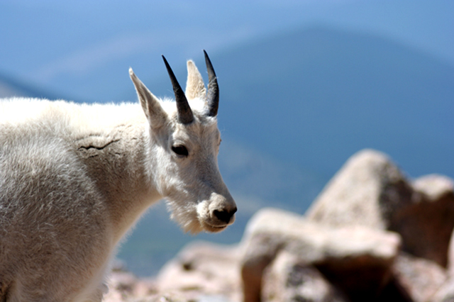
Image 1: Close up of fossilized dinosaur foot prints from Dinosaur Ridge, CO. Dinosaurs: What They Stepped In, A Virtual Tour of Dinosaur Ridge All pictures in this show are by Dr. Alley unless noted; some of the pictures here feature PSU graduate and noted scientist Matt Spencer.

Image 2: Two images. Left: Outcropping of rock that has been tipped up as the Rockies were formed. Second: Fossilized dinosaur prints. Dinosaur Ridge, just west of Denver, Colorado, is part of the Morrison Fossil Area National Natural Landmark as designated by the National Park Service. In the Cretaceous Period of the Mesozoic Era, about 100 million years ago, the area that is now the Ridge sat on the edge of the great Interior Seaway that extended eastward across Kansas, and connected the Gulf of Mexico with the Arctic Ocean. Sediments were deposited, hardened and then tipped up (picture at right) as the Rockies were raised just to the west. The dinosaur trackway (lower right) is the big attraction at the Ridge, although there is quite a bit more to see (including modern rabbits).

Image 3: Dinosaur footprints. An insert image shows one of the larger Iguanodon tracks with three kids hands in it for scale. The dinosaur tracks really are spectacular. Various dinosaurs walked across the muddy surface, probably heading for a water hole. The little sign (bottom of the picture on the left) points to a three-toed Ornithomimus track. A picture of one of the larger Iguanodon tracks is shown in the inset, with kids’ hands for scale.

Image 4: Various animal burrows from a shallow-water deposit near the dinosaur trackways. Shown here are various animal burrows from a shallow-water deposit near the dinosaur trackways (with an interpretive sign to give you an idea of the scale). Modern muds similar to these are commonly burrowed by creatures looking for food or avoiding enemies. After a mud layer is deposited, it usually takes a while for the mud to stabilize, and critters to move in and burrow the heck out of the mud, as seen here.

Image 5: Two pictures. Top: Burrowed rock shows burrows from big and small animals. Bottom: Heavily burrowed area buried by a moderately burrowed area. A careful examination of the burrowed rocks from the previous picture shows that various critters were stirring the mud, including big ones (pink arrow) and little ones (blue arrow). Not every layer gets burrowed--if there is too little oxygen to support critters, or too little for critters to eat, or the layer is buried too rapidly, then burrowing may be restricted or absent. Here, the heavily burrowed layer (far right, green arrow) is buried under a moderately burrowed layer covered with ripple marks (the two red arrows in the upper left of the picture point along ripple-mark crests). In turn, the rippled layer was buried by another layer, which was buried by another… (see next slide).

Image 6: Close up of a rock showing a rippled layer covered up by another rippled layer. The previous slide showed a burrowed layer buried beneath a rippled layer. Here, a different rippled layer was covered up by yet another rippled layer. (If you don’t see it, the next slide adds some annotations to help.)

Image 7: Close up of a rock showing a rippled layer covered up by another rippled layer. In case you didn’t see the features in the previous slide, the solid pink line divides the layer on the bottom (which in the picture is to the upper right) from the layer on top (which in the picture is to the lower left). The crests of two ripples on the layer on the bottom are marked by the light-blue dot-dash lines, and the crests of five ripples on the layer on the top are marked by the dark-blue dotted lines.

Image 8: Dinosaur tracks. As interesting as ripples and burrows may be, most people go to Dinosaur Ridge to see dinosaur tracks.

Image 9: Three close ups of dinosaur tracks. And, here are a few more pictures of the main trackway at Dinosaur Ridge. Many more trackways have been reported along the Front Range near Denver, and there are other tracks at Dinosaur Ridge in other rock layers (some coming later in this show), but this is the easiest one to see.

Image 10: Two images. Left: Dinosaur bone still in the rock. Right: Layered rock with a orange ayer in the middle. The yellow-orange-ish layer is volcanic ash, from a very large eruption nearby, which is sandwiched between more-ordinary sedimentary rocks.

Image 11: Dr. Alley standing next to an edge-on dinosaur track. On the other side of Dinosaur Ridge from the “main” trackway seen earlier, you can see dinosaur tracks edge-on, such as this one indicated by Dr. Alley. The next picture includes an outline of the track.

Image 12: Edge-on dinosaur track.

Image 13: Another Edge-on dinosaur track. Matt Spencer with dinosaur track, Dinosaur Ridge, near Denver. The next picture is a close-up with this track outlined.

Image 14: close up of the previous edge on dinosaur track with the track outlined.

Image 15: Previous image turned upside down showing what a dino footprint would look like if the rock turned upside down. Dinosaurs didn’t walk on the ceiling. We just turned the previous picture upside-down, but if you found a track this way in nature, you should conclude that the rock has been turned upside-down.

Image 16: Mountain goat. A long and fascinating story links the dinosaurs tromping on mud when Denver was a coastal city, and this mountain goat looking down toward Denver from Mt. Evans 65 million years later. The giant meteorite that killed the dinosaurs left their “jobs” open to others, and evolution filled those jobs with the creatures we now know and enjoy.

Word Document of Unit 11 V-trips

Want to see more?

Here are some optional vTrips you might also want to explore! (No, these won't be on the quiz!)

Dinosaur National Monument
(Provided by UCGS)