
New Orleans
Early Smart Building along the banks of the Mississippi River
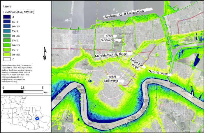
It is a common misconception, widely promulgated during the media’s coverage of Hurricane Katrina, that the city of New Orleans is below sea level. In fact, almost 53% of the city is at or above sea level (Campanella, 2007). Before the construction of flood protection levees along the Mississippi River, seasonal spring floods caused the river to overflow its banks, depositing sediment in the floodplain along both sides of the river. Sediment deposition was most intense directly at the bank and decreased with distance from the river, gradually building up a natural levee elevated above the surrounding land and typical river stages. From the topographic high of the natural levee, the land surface slopes downward to the below sea level backswamp. The natural levee of the Mississippi is visible in the map of above sea level elevations in New Orleans below, following the crescent shape of the river.
Another major above sea level topographic feature in New Orleans is the Metairie/Gentilly Ridge, a single feature that is known by either name depending on which part of the city it traverses. Formed by the natural levees of a relic distributary of the Mississippi River when its mouth was to the east of New Orleans, the ridge sits several feet above sea level and the surrounding lowlands. The Esplanade Ridge, also formed by a small Mississippi River distributary channel, connects the Metairie/Gentilly Ridge to the river’s natural levee. Most other areas in the city above sea level are artificial, the result of land reclamation along the lakefront, dredged material disposal along navigation canals, and construction of flood protection levees.
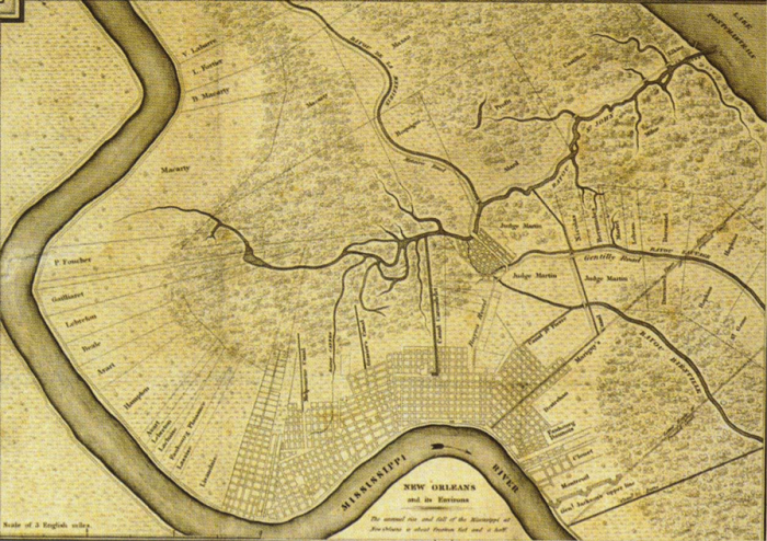
New Orleans was established as a French colony on a crescent-shaped piece of land between the Mississippi River and Lake Pontchartrain, about 80 km from the river’s mouth. The original settlement was built on high ground adjacent to the river and was bordered by low-lying cypress swamps to the North. A map of the further-developed city in 1829 is given below, with some constructed drainage canals already visible. Note that the city is confined to areas above sea level, the river’s natural levee and a small settlement on the Gentilly Ridge connected to the French Quarter by the Esplanade Ridge.
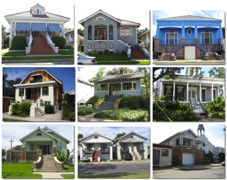
During the city’s early development, historic homes in the area employed a smart building approach despite being built above sea level. Realizing the threats of flooding from both the river and the sea, early New Orleans residents showcase houses that are elevated with elaborate architecture or houses that employ basements that are actually on the first floor. Some examples of these houses are shown below and show how well-prepared the communities were as a result of living with and being surrounded by water.
Due to its unique geography, New Orleans is subject to three types of flood risk: river floods from the Mississippi River, storm surge-induced floods from Lake Pontchartrain and Lake Borgne to the East of the city, and heavy rain-induced flooding due to the low-lying city’s poor drainage. The realization of these threats throughout the city’s history has influenced the development of its flood protection system. From its inception, New Orleans was routinely flooded by the high spring runoff floods of the river. To prevent these floods, the same strategy of heightening the natural overflow banks has been implemented at various scales. Though it did not directly inundate New Orleans, the great Mississippi flood of 1927 resulted in the authorization of the Mississippi Rivers and Tributaries Project, whose construction ensured protection from further river floods. Levees were constructed along most of the lower Mississippi River with 7.5 m above sea level levees fronting the city of New Orleans.