
Plate Tectonics
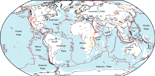
Plate Tectonics
Take a look at the global base map that shows, and identifies with labels, the different tectonic plates of the Earth. You will notice that the margins of the plates are very irregular and that the boundaries of the plates fit together similar to a jigsaw puzzle. If you look very closely, you will also see that the margins of the plates are sometimes located on the edge of the continents, and sometimes the margins are located in the middle of the oceans. As previously mentioned, these plates are not static, but, instead, move at very slow rates, averaging just a few centimeters per year. In the course of very long intervals of time, such as 100,000 years, these very slow rates of motion can add up to hundreds of meters or kilometers of total motion.
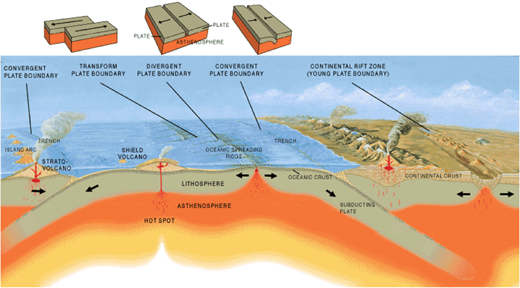
The result of these rigid plates moving around is the creation of one of three different types of plate boundaries: divergent, convergent, and transform boundaries.
Divergent Boundaries
This is a boundary between two plates that are moving apart from one another. For example, if you look at the global base map again, you will see a plate boundary that extends all the way through the middle of the Atlantic Ocean. This is a divergent boundary where the North and South American Plates are moving away from the African and Eurasian Plate. At this location, new oceanic crust is forming (see Illustration of three types of tectonic boundaries) as underlying mantle material flows up through the gap created by the separation of the plates. It is referred to as the Mid-Atlantic Ridge because along this margin the oceanic crust is elevated and creates a ridge. Because the edges of the continents on opposite sides of the divergent boundary are considered tectonically inactive, they are called passive continental margins. Divergent boundaries can also extend across continental crust – such as where the Arabian Plate is moving away from the African Plate and in the process creating the Red Sea Rift.
Convergent Boundaries
Convergent boundaries are those where plates are colliding with one another, forming either a subduction zone or continental collision. There are two types of convergent boundaries: continental-oceanic and continent-continent.
Continental-Oceanic Boundaries: In the case of a continental-oceanic crust collision, the denser oceanic plate will fold or subduct underneath the less dense continental plate. For example, take another look at the global map of the tectonic plates, and you will notice that there is a boundary along the entire length of the western edge of South America. This is a margin where the Nazca Plate is in direct contact with the South American Plate. Earthquakes, volcanoes, and mountains are often associated with convergent margins (see Illustration below of the three types of tectonic boundaries), and all three of these occur along the western edge of South America.
Continent-Continent Boundaries: A continent-continent collision, or orogeny, occurs when two continental plates collide, fold, fault, and uplift, creating mountain ranges. The Himalaya Mountains are actively building as the result of the compressional forces put upon the Indo-Australian Plate and the Eurasian Plate pushing against each other during the last 30 to 50 million years.
Transform Boundaries: Transform boundaries exist where plates are sliding past, or more scientifically stated: shearing past one another. The San Andreas Fault of southern California is one of the most recognized transform boundaries where the Pacific Plate interacts with the North American Plate. During the approximately 30 million years that the San Andreas boundary has been active, there have been approximately 550 kilometers of movement.
A final thing to keep in mind is that plate tectonic interactions generate stresses that can lead to the development of fractures in the lithosphere. If the movement of the lithosphere takes place across these fractures, they are called faults. Three main types of faults are recognized: 1) normal faults, 2) reverse faults, and 3) transform faults. You probably have realized that transform faults, like transform boundaries, are those where opposing sides of the fault slide past one another. In the case of a normal fault, part of the lithosphere slides down past the lithosphere of the opposing side, whereas in the case of a reverse fault, part of the lithosphere moves over the top of the lithosphere on the opposing side of the fault. Understanding faults and faulting will become important later on, in Module 6, when the creation of tsunamis is covered.
For more information on plate tectonics, check out the following links with the U.S. Geological Survey (USGS):
- USGS Historical Perspective: useful information about the history of thought regarding plate tectonics
- USGS Developing the Theory: information regarding how the modern theory of plate tectonics was developed
- USGS Understanding Plate Motions: additional information regarding the types and characteristics of different plate boundaries and how different plates interact with one another