Glaciations
What are the direct and indirect effects of glaciations on coastal zones?
Glaciated Coasts
The effects of glacial activity along coastal zones can be broadly broken into two categories. Direct effects would include the shaping of coastal zones in high latitude areas toward the north and south poles of the planet, where glacial ice is in direct contact with the land surface. Indirect effects would include low latitude areas toward the Equator where glacial ice is not a permanent feature in coastal zones.
Direct Effects on Coasts by Glaciation
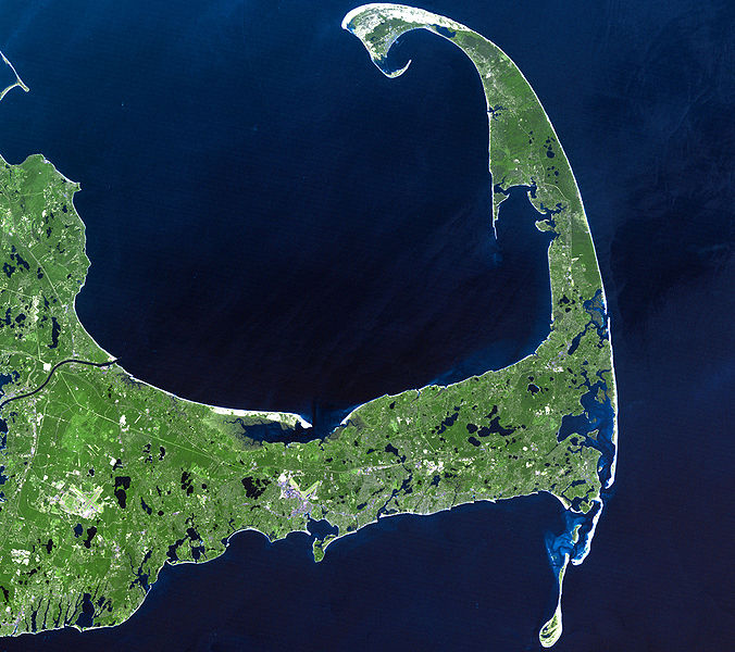
The New England states of northeastern United States are a good example of where glacial ice has had a direct and obvious impact on the coastal morphology – specifically along the coast of the state of Massachusetts and around the city of Boston. Between approximately 100,000 and 18,000 years ago, a large percentage of the North American continent was covered in a several kilometers thick sheet of ice that progressively advanced southward during this time. As this massive ice sheet advanced, it scoured and scraped the underlying ground. The scoured sediment was transported as the ice sheet advanced into progressively lower latitudes. Sediment was also carried by meltwater streams that existed out in front of the ice sheet. The result is that glaciers and ice sheets such as this can move substantial amounts of sediment and act to create a unique suite of glacial landforms such as terminal moraines and outwash deposits. In fact, it is these types of deposits that formed the surface sediments of famous New England places such as Cape Cod, Martha’s Vineyard, and Nantucket.
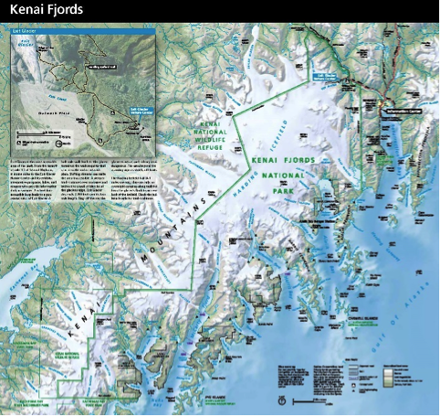
Another type of direct effect that ice sheets and glaciers can have along the coast does not involve the deposition of sediment, but rather the erosion of sediment and the creation of features such as valleys. On a global basis, the modern-day fjords were created during the most recent global-wide glacial event that led to the advance and growth of ice sheets and mountain glaciers everywhere. It was during this period of time that the ice carved out what would later become known as fjords. Since 18,000 years ago, ice sheets and glaciers have been melting worldwide, and this extra water in the ocean basins has led to a rise in sea level and flooding of the glacially carved valleys. In fact, famous fjords of places such as Alaska, Chile, and Norway are the direct result of glaciers once extending to the sea from high areas, carving very long and often deep but generally narrow valleys.

Indirect Effects on Coasts by Glaciation
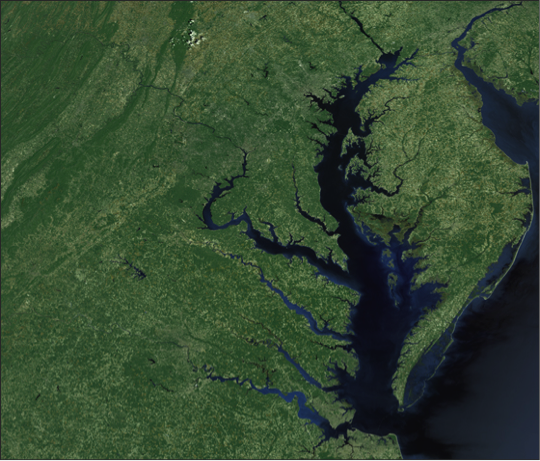
The indirect effects of glaciations are considered to be associated with the lowering of sea level during the last Ice Age and the subsequent rise of sea level that coincided with the melting of the ice-age ice sheets and glaciers. During the period of major ice sheet and glacial expansion, sea level was approximately 120 meters lower than it currently is today. During this period of lowered sea level, rivers systems on a global extent would have extended across the continental shelves, which were subaerially exposed because of the lowered sea level. River valleys cut across the continental shelves as rivers flowed to reach the new elevation of sea level. The valleys were progressively widened and deepened, and during deglaciation melt, water was released back into the ocean basins and sea level progressively rose so that the river valleys became inundated. This indirect process of glacial and ice sheet influence on the coastal zone is evident in the Chesapeake Bay of the eastern United States. The Chesapeake Bay, as well as many other drowned river valleys, provide critical habitat for freshwater, brackish, and marine water species of plants and animals, but are becoming a progressively more endangered habitat because of the influx of agricultural nutrients through runoff and discharge of wastewater into these environments.