GEOSC 10
Geology of the National Parks

Virtual Field Trips

PrintPrint

Virtual Field Trip #1: Death Valley National Park

Death Valley National Park
Zabriskie Point, in midwinter.
Zabriskie Point, in midwinter. The soft sediments at Zabriskie Point were deposited in an old lake, and are being eroded into the beautiful features seen here. The snow-covered peaks in the background tower two miles above the valley floor. (Photo by Penn State graduate, now University of New Mexico professor, Peter Fawcett.)
Badwater in midwinter.
Badwater in midwinter. Peter Fawcett, noted Penn State alumnus and University of New Mexico professor, at 282 feet below sea level. The little bit of water from a midwinter storm will evaporate quickly.
Salt flats in midwinter, Death Valley.
Salt flats in midwinter, Death Valley. Water, such as seen in the previous picture, carries dissolved minerals (ask a plumber who has tried to remove a faucet in a house with hard water if you don't believe this!). When the water evaporates, the salt is left. Photo by Peter Fawcett.
20 mule team transporting borax.
20-mule team. The salts deposited in Death Valley included valuable materials such as borax, containing boron dissolved from volcanic and other rocks around the valley. The salts were mined, and the borax hauled out by 20-mule teams. This is a picture from a reenactment of the mule teams, years after the mining ceased. Photo by Ed Derobertis of the National Park Service.
Ronald Reagan (before he was president) advertising a laundry detergent containing borax.
Probably the most familiar of the many uses of borax is in laundry detergents. Before he was president of the United States, actor Ronald Reagan advertised a laundry detergent containing borax, as shown in this photo from the National Park Service archives.
An alluvial fan behind a salt flat.
Another salt flat is shown here. Behind the salt flat, at the foot of the mountains, is an alluvial fan, a pile of gravel brought down into the valley from the mountains by streams that run for a short while after rainstorms. The vertical distance between the lowest point (end of the pink arrow) and highest point (end of the yellow arrow) on the fan is greater than the vertical distance from Spring Creek to the top of Mt. Nittany near Penn State¹s University Park Campus--the fan is taller than most eastern mountains! The scale of things in Death Valley is immense, and very difficult to comprehend. Photo by Peter Fawcett.
Mountains with salt flat at the bottom.
Again, putting Penn State’s Mt. Nittany, or many other eastern mountains, into this picture wouldn’t change it much - they would reach only part of the way from the salt flat at the bottom (shown by the orange arrow) up the fan (the top of the fan is shown by the yellow arrow), far shorter than the peaks in the picture. Photo by Peter Fawcett
Shoreline Butte
During the ice age, more rain fell in Death Valley because storm tracks had moved, and less water evaporated because temperatures were lower than today. A huge lake filled Death Valley then. In this rather fuzzy slide downloaded from the USGS-National Park Service website, the horizontal lines (the ends of one are shown by the blue arrows) are old beaches from that lake. The photo of Shoreline Butte is by Marli Miller.
Gravel washed into the valley by streams.
Some of the gravels washed into the valley by streams are shown in this photo by Peter Fawcett.
Sand dunes
Deserts are not dominated by dunes in many places, but dunes do occur. The streams flowing into Death Valley carry salts, big rocks, but also sand. If the sand is piled by wind, beautiful forms may result, such as these. Photo by Paul Stone, United States Geologic Survey
Devil's Racetrack
The enigmatic Devil's Racetrack. The stones rather clearly have moved across the surface of the salt flat. Strong winds during wet times are probably involved. Perhaps a thin water layer forms in a winter storm, freezes on top on a cold night, and then the wind drags the ice carrying the rocks. Photo by Marli Miller, from the Death Valley National Park website.
Hanaupah Fault
Death Valley was dropped along faults (or the mountains were raised, or both). The Hanaupah Fault (between the blue arrows) cuts the toe of an alluvial fan coming down from Telescope Peak, shown in this photo by Marli Miller from the Death Valley National Park website.
Hanaupah Fault
A closer view of The Hanaupah Fault (between the blue arrows) as seen in the previous picture, with labels showing which side of the fault was raised (“UP”) and lowered (“DOWN”). Photo by Marli Miller, from the Death Valley National Park website.
Craters in Death Valley
Hot rocks occur at shallow depth under Death Valley, and break through occasionally in volcanoes, usually coming up along faults; farther to the south, stronger volcanism has made the sea floor of the Gulf of California. In Death Valley, the eruptions are not especially strong, but they have made craters, such as those in the Ubehebe volcanic field, shown in these photos.
Cinder cones.
Sometimes, volcanoes make small cinder cones, composed of little rocks and hardened blobs of lava thrown through the air. And, sometimes faults move rocks horizontally, as shown here (upper left without lines, and lower right with fault shown by dashed line and motion by arrows) for Split Cinder Cone in Death Valley. Most of the faulting in Death Valley is related to the dropping of the Valley and raising of the mountains, but horizontal motions such as this do occur occasionally.

Virtual Field Trip #1: Death Valley
Click Here for text alternative for Virtual Field Trip #1

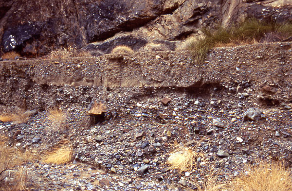
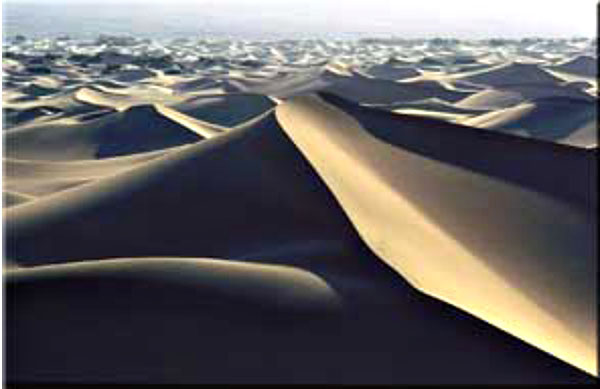
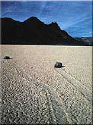
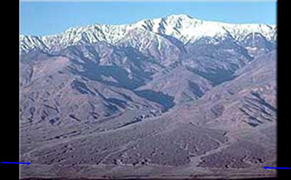
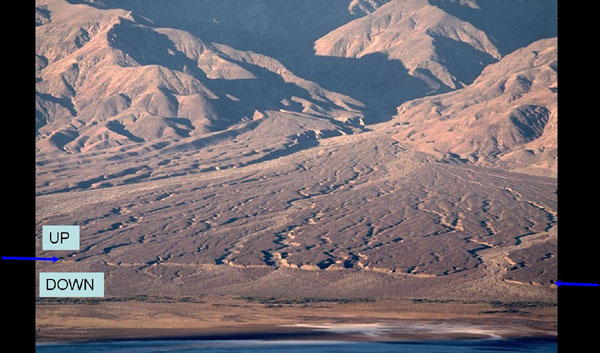
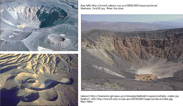
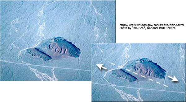
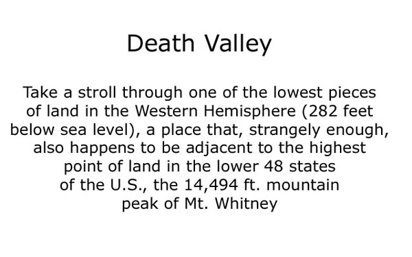
Image 1: Death Valley: Take a stroll through one of the lowest peices of land in the Western Hemisphere (282 feet below sea level), a place that, strangely enough, also happens to be adjacent to the highest point of land in the lower 48 states of the U.S., the 14, 494 ft. mountain peak of Mt. Whitney.

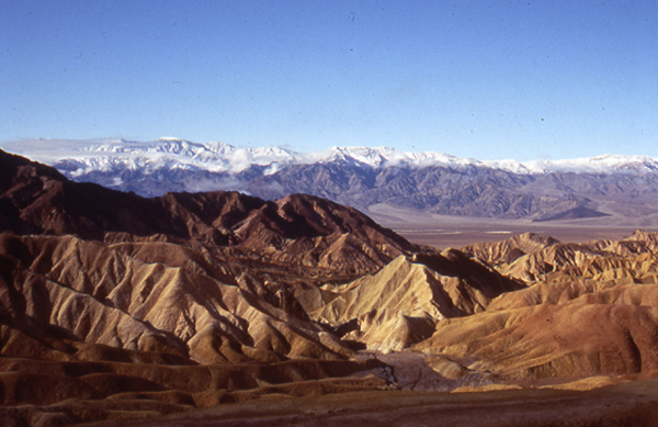
Image 2: Zabriskie Point, in midwinter. The soft sediments at Zabriskie Point were deposited in an old lake, and are being eroded into the beautiful features seen here. The snow-covered peaks in the background tower two miles above the valley floor. (Photo by Penn State graduate, now University of New Mexico professor, Peter Fawcett.)

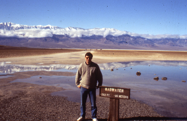
Image 3: Badwater in midwinter. Peter Fawcett, noted Penn State alumnus and University of New Mexico professor, at 282 feet below sea level. The little bit of water from a midwinter storm will evaporate quickly.

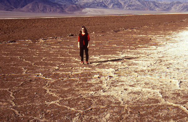
Image 4: Salt flats in midwinter, Death Valley. Water, such as seen in the previous picture, carries dissolved minerals (ask a plumber who has tried to remove a faucet in a house with hard water if you don't believe this!). When the water evaporates, the salt is left. Photo by Peter Fawcett.

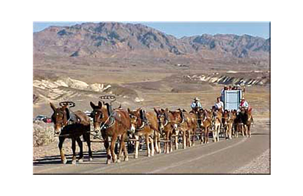
Image 5: 20-mule team. The salts deposited in Death Valley included valuable materials such as borax, containing boron dissolved from volcanic and other rocks around the valley. The salts were mined, and the borax hauled out by 20-mule teams. This is a picture from a reenactment of the mule teams, years after the mining ceased. Photo by Ed Derobertis of the National Park Service.

Image 6: Probably the most familiar of the many uses of borax is in laundry detergents. Before he was president of the United States, actor Ronald Reagan advertised a laundry detergent containing borax, as shown in this photo from the National Park Service archives.

Image 7: Another salt flat is shown here. Behind the salt flat, at the foot of the mountains, is an alluvial fan, a pile of gravel brought down into the valley from the mountains by streams that run for a short while after rainstorms. The vertical distance between the lowest point and highest point on the fan is greater than the vertical distance from Spring Creek to the top of Mt. Nittany near Penn Stateas University Park Campus--the fan is taller than most eastern mountains! The scale of things in Death Valley is immense, and very difficult to comprehend. Photo by Peter Fawcett.

Image 8: Again, putting Penn State’s Mt. Nittany, or many other eastern mountains, into this picture wouldn’t change it much - they would reach only part of the way from the salt flat at the bottom (shown by the orange arrow) up the fan (the top of the fan is shown by the yellow arrow), far shorter than the peaks in the picture. Photo by Peter Fawcett

Image 9: During the ice age, more rain fell in Death Valley because storm tracks had moved, and less water evaporated because temperatures were lower than today. A huge lake filled Death Valley then. In this rather fuzzy slide downloaded from the USGS-National Park Service web site, the horizontal lines (the ends of one are shown by the blue arrows) are old beaches from that lake. The photo of Shoreline Butte is by Marli Miller.

Image 10: Some of the gravels washed into the valley by streams are shown in this photo by Peter Fawcett.

Image 11: Deserts are not dominated by dunes in many places, but dunes do occur. The streams flowing into Death Valley carry salts, big rocks, but also sand. If the sand is piled by wind, beautiful forms may result, such as these. Photo by Paul Stone, United States Geologic Survey

Image 12: The enigmatic Devil's Racetrack. The stones rather clearly have moved across the surface of the salt flat. Strong winds during wet times are probably involved. Perhaps a thin water layer forms in a winter storm, freezes on top on a cold night, and then the wind drags the ice carrying the rocks. Photo by Marli Miller, from the Death Valley National Park web site.

Image 13: Death Valley was dropped along faults (or the mountains were raised, or both). The Hanaupah Fault (between the blue arrows) cuts the toe of an alluvial fan coming down from Telescope Peak, shown in this photo by Marli Miller from the Death Valley National Park web site.

Image 14: A closer view of The Hanaupah Fault (between the blue arrows) as seen in the previous picture, with labels showing which side of the fault was raised (“UP”) and lowered (“DOWN”). Photo by Marli Miller, from the Death Valley National Park web site.

Image 15: Hot rocks occur at shallow depth under Death Valley, and break through occasionally in volcanoes, usually coming up along faults; farther to the south, stronger volcanism has made the sea floor of the Gulf of California. In Death Valley, the eruptions are not especially strong, but they have made craters, such as those in the Ubehebe volcanic field, shown in these photos.

Image 16: Sometimes, volcanoes make small cinder cones, composed of little rocks and hardened blobs of lava thrown through the air. And, sometimes faults move rocks horizontally, as shown here (upper left without lines, and lower right with fault shown by dashed line and motion by arrows) for Split Cinder Cone in Death Valley. Most of the faulting in Death Valley is related to the dropping of the Valley and raising of the mountains, but horizontal motions such as this do occur occasionally.

Virtual Field Trip #2: West Yellowstone, Earthquake Lake

Title slide. See caption
Earthquakes! US Forest Service Madison River Canyon Earthquake Area.
Cabin Creek Scarp
On the night of August 17, 1959, at 11:37 PM, a large (magnitude 7.5) earthquake struck just northwest of Yellowstone, near Hebgen Lake in the Madison River Canyon of Montana. Land on the west side of the Cabin Creek Fault moved down about 21 feet (almost 7 m) relative to land on the east in a sudden drop that shook the surroundings, forming the Cabin Creek Scarp, shown here. (A scarp or escarpment is a steep ramp connecting places that are more nearly horizontal; think of a wheelchair ramp between sidewalks down here and up there.)
The scar left after a massive landslide
The shaking caused a massive landslide from the south side of the Madison River Canyon. An estimated 80 to 90 million tons of rock and debris thundered into the canyon, forming a layer estimated at 400 feet (120 m) thick in the bottom of the canyon and bouncing another 400 feet up the north wall. The scar left when the rocks fell is shown here. 26 people died in this vicinity, most in a campground that was buried under the landslide debris. (Two more were killed by a falling boulder elsewhere.)
A closer view of the scar left after a massive landslide
This closer view of the scar from the landslide shows large trees next to the slide and growing in the scar, emphasizing the immense size of the slide.
A huge bolder carried across the valley after a landslide
Huge boulders were carried across the valley and up the other side. The rapidly moving mass of rock blasted air and river water in front of it; some survivors reported having their clothes ripped off by the force of the blast.
Another shot of the immense boulders carried across the valley
Another shot of the immense boulders carried across the valley by the rapidly moving mass of rock.
Earthquake Lake formed when the landslide dammed the Madison River
The landslide dammed the Madison River, and the trapped water rose to form Earthquake Lake, drowning many trees that still are visible, as seen here. Quick work by the US Army Corps of Engineers stabilized and lowered the new dam. Landslide-dammed lakes often overtop their dams, cut down through the loose debris, and release a devastating flood; this was avoided by the quick government response.
A house that ws knocked down and flooded by the earthquake
Hebgen Lake was a reservoir a little upstream of the new Earthquake Lake. On the night of the earthquake, Hebgen Lake's dam cracked and water washed over, but the dam did not fail. The land under the lake tilted, raising one side and lowering the other. One person ran safely from her house as the lake rose and the house and land slipped into the waters. Huge waves sloshed back and forth in the lake after the quake. Houses knocked down and flooded by the tilting and waves are still visible, as seen here."
Monument Geyser, in the Upper Geyser Basin, Yellowstone National Park
The quake caused many changes in Yellowstone, stopping some geysers, starting others, and changing the patterns of still others. Many tourists fled in panic, small landslides and rockfalls were triggered, dishes fell off walls in houses, etc., but no one was seriously injured in the park. Earthquakes such as this probably have occurred many times over the geologic history of Yellowstone, although this was the largest experienced in Yellowstone since modern instruments were installed to provide measurements. Monument Geyser, in the Upper Geyser Basin, is shown here; this one was not affected more than most, but it's pretty.

Virtual Field Trip #2: West Yellowstone
Click Here for Text Alternative for Virtual Field Trip #2

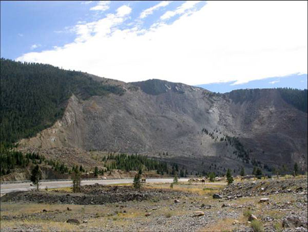
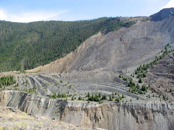
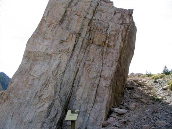
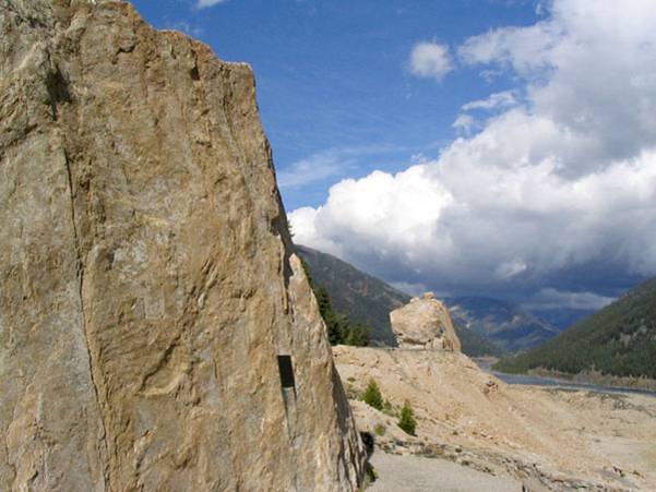
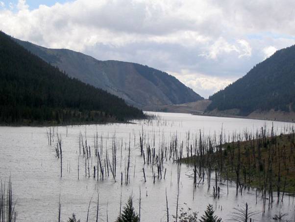
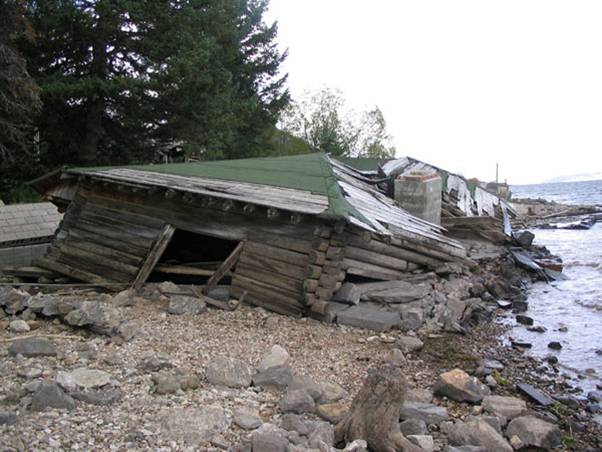
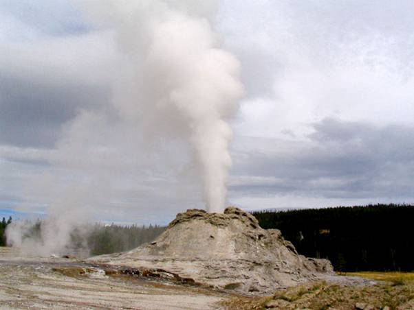
Image 1: Earthquakes! Take a quick virtual tour with Dr. Alley through the U.S. Forest Service Madison River Canyon Earthquake Area. (last picture is in Yellowstone National Park)

Image 2: On the night of August 17, 1959, at 11:37 PM, a large (magnitude 7.5) earthquake struck just northwest of Yellowstone, near Hebgen Lake in the Madison River Canyon of Montana. Land on the west side of the Cabin Creek Fault moved down about 21 feet (almost 7 m) relative to land on the east in a sudden drop that shook the surroundings, forming the Cabin Creek Scarp, shown here. (A scarp or escarpment is a steep ramp connecting places that are more nearly horizontal; think of a wheelchair ramp between sidewalks down here and up there.)

Image 3: The shaking caused a massive landslide from the south side of the Madison River Canyon. An estimated 80 to 90 million tons of rock and debris thundered into the canyon, forming a layer estimated at 400 feet (120 m) thick in the bottom of the canyon and bouncing another 400 feet up the north wall. The scar left when the rocks fell is shown here. 26 people died in this vicinity, most in a campground that was buried under the landslide debris. (Two more were killed by a falling boulder elsewhere.)

Image 4: This closer view of the scar from the landslide shows large trees next to the slide and growing in the scar, emphasizing the immense size of the slide.

Image 5: Huge boulders were carried across the valley and up the other side. The rapidly moving mass of rock blasted air and river water in front of it; some survivors reported having their clothes ripped off by the force of the blast.

Image 6: Another shot of the immense boulders carried across the valley by the rapidly moving mass of rock.

Image 7: The landslide dammed the Madison River, and the trapped water rose to form Earthquake Lake, drowning many trees that still are visible, as seen here. Quick work by the US Army Corps of Engineers stabilized and lowered the new dam. Landslide-dammed lakes often overtop their dams, cut down through the loose debris, and release a devastating flood; this was avoided by the quick government response.

Image 8: Hebgen Lake was a reservoir a little upstream of the new Earthquake Lake. On the night of the earthquake, Hebgen Lake’s dam cracked and water washed over, but the dam did not fail. The land under the lake tilted, raising one side and lowering the other. One person ran safely from her house as the lake rose and the house and land slipped into the waters. Huge waves sloshed back and forth in the lake after the quake. Houses knocked down and flooded by the tilting and waves are still visible, as seen here.

Image 9: The quake caused many changes in Yellowstone, stopping some geysers, starting others, and changing the patterns of still others. Many tourists fled in panic, small landslides and rockfalls were triggered, dishes fell off walls in houses, etc., but no one was seriously injured in the park. Earthquakes such as this probably have occurred many times over the geologic history of Yellowstone, although this was the largest experienced in Yellowstone since modern instruments were installed to provide measurements. Monument Geyser, in the Upper Geyser Basin, is shown here; this one was not affected more than most, but it's pretty.

Virtual Field Trip #3: Alaska & San Francisco

Title page: More Earthquakes! Alaska & San Francisco
vTrip #3
Hanning Bay fault scarp on Montague Island
Alaska Earthquake, March 27, 1964. The geologist on the left stands in front of the Hanning Bay fault scarp on Montague Island. During the earthquake, the scarp formed when the rocks on the right dropped suddenly relative to the rocks on the left--the scarp is 12 feet high beside the geologist, and 14 feet high near the trees in the background.
Apartment building cracked to the ground
Alaska Earthquake, March 27, 1964. The Four Seasons Apartments in Anchorage was a six-story lift-slab reinforced concrete building, which cracked to the ground during the earthquake. The building was under construction, but structurally completed, at the time of the earthquake.
Destruction from the Alaska 1964 earthquake
Alaska Earthquake, March 27, 1964. The shaking caused some land to slide toward the ocean. Everything in the lower-left corner of the pictured moved about 11 feet farther to the lower left in the direction shown by the magenta arrow, toward the ocean bluffs that are just out of the picture in that direction. The strip of land between the yellow arrows dropped by 7 to 10 feet, as indicated by those arrows. Notice that several houses were left hanging over the void, to be destroyed later. The collapsed apartment building from the previous slide is visible at the top of this picture (blue arrow)."
Buckeling train tracks
Alaska Earthquake, March 27, 1964. The shaking caused the banks on both sides of the river to landslide toward the water, carrying the rails along, as shown by the blue arrows at the bottom. This in turn caused the rails to bend, and also buckled up the center of the bridge, as shown here. This is near the head of Turnagain Arm, not far from Anchorage.
The Denali Theater dropped below street level
Alaska Earthquake, March 27, 1964. The Denali Theater was built on a block that dropped as the shaking of the earthquake moved land toward the sea, but Fourth Avenue was just beyond that moving block and did not drop. The marquee is now at eye-level.
Government Hill Elementary School in Anchorage.
Alaska Earthquake, March 27, 1964. This was the Government Hill Elementary School in Anchorage. It was not designed as a split-level.
The “Million Dollar” railroad bridge that fell sideways
Alaska Earthquake, March 27, 1964. Bridges and buildings are usually designed so that they don’t fall down. An earthquake moves the ground horizontally as well as vertically, so buildings and bridges often fail by falling sideways, as happened to the “Million Dollar” railroad bridge over the Copper River.
The Bay Bridge failed during the 1989 earthquake
Loma Prieta, California, Earthquake, October 17, 1989. The Bay Bridge between San Francisco and Oakland failed during the earthquake, with the upper deck falling onto the lower deck of the double-decker bridge, killing one person.
Cracked Driveway
Loma Prieta, California, Earthquake, October 17, 1989. The shaking of the earthquake caused landsliding and other land motion, destroying this driveway in the Santa Cruz Mountains.
bridge knocked off it's supports by earthquake
Loma Prieta, California, Earthquake, October 17, 1989. The shaking knocked this section of Highway 1 near Watsonville off its bridge supports, which poked through the road bed.
Collapsed Cypress Viaduct of Interstate 880 in Oakland
Loma Prieta, California, Earthquake, October 17, 1989. The shaking of the earthquake caused collapse of the Cypress Viaduct of Interstate 880 in Oakland. 40 of the 67 fatalities caused directly by the earthquake happened here, primarily to drivers on the lower deck who were crushed by falling of the upper deck.

Virtual Field Trip #3 Alaska and San Franscisco
Click Here for Text Alternative of Virtual Field Trip #3

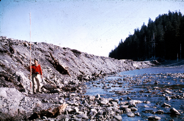
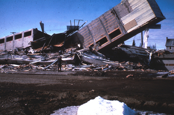
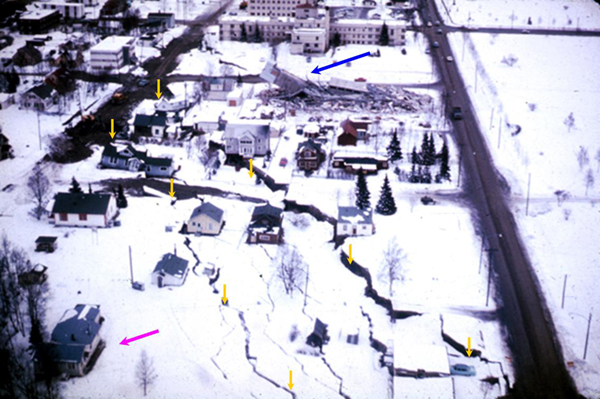
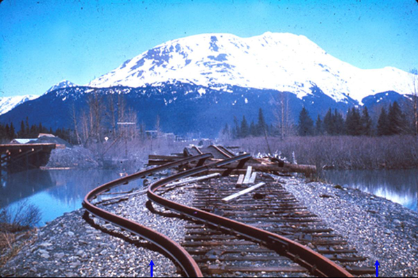
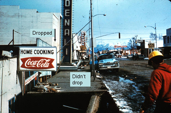
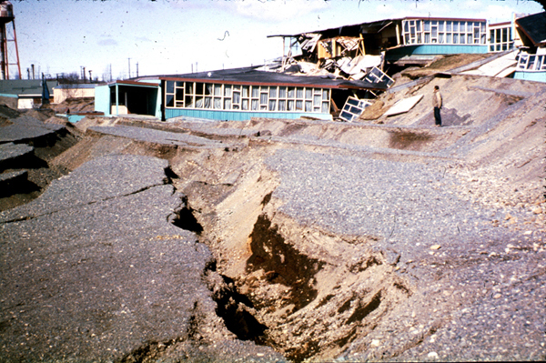
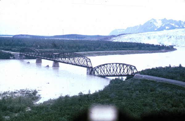
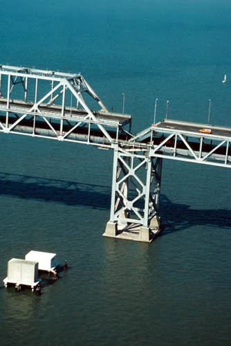
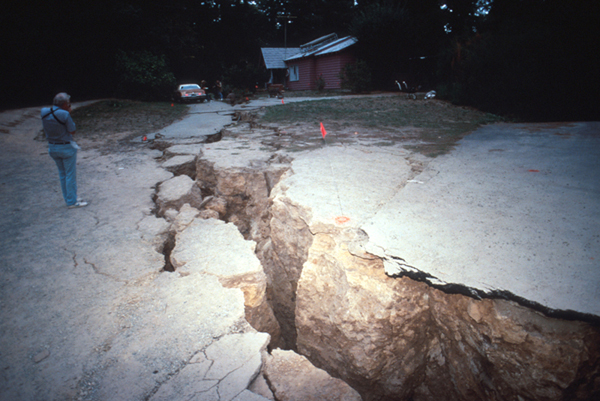
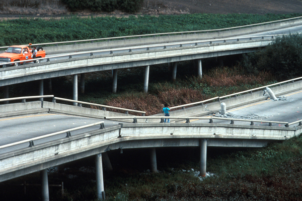
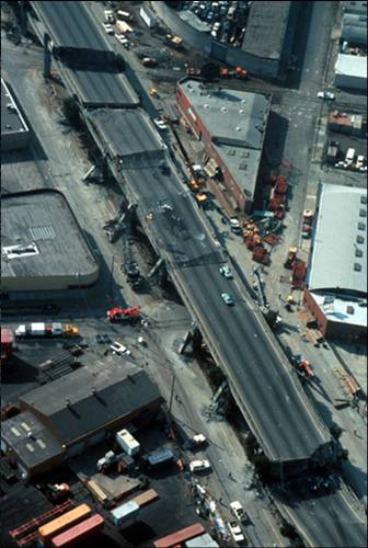
Image 1: More Earthquakes! Visit Alaska & San Francisco to get a glimpse into the effects of major earthquakes. Photos courtesy of the U.S. Geological Survey

Image 2: Alaska Earthquake, March 27, 1964. The geologist on the left stands in front of the Hanning Bay fault scarp on Montague Island. During the earthquake, the scarp formed when the rocks on the right dropped suddenly relative to the rocks on the left--the scarp is 12 feet high beside the geologist, and 14 feet high near the trees in the background.

Image 3: Alaska Earthquake, March 27, 1964. The Four Seasons Apartments in Anchorage was a six-story lift-slab reinforced concrete building, which cracked to the ground during the earthquake. The building was under construction, but structurally completed, at the time of the earthquake.

Image 4: Alaska Earthquake, March 27, 1964. The shaking caused some land to slide toward the ocean. Everything in the lower-left corner of the picture moved about 11 feet farther to the lower left in the direction shown by the magenta arrow, toward the ocean bluffs that are just out of the picture in that direction. The strip of land between the yellow arrows dropped by 7 to 10 feet, as indicated by those arrows. Notice that several houses were left hanging over the void, to be destroyed later. The collapsed apartment building from the previous slide is visible at the top of this picture (blue arrow).

Image 5: Alaska Earthquake, March 27, 1964. The shaking caused the banks on both sides of the river to landslide toward the water carrying the rails along, as shown by the blue arrows at the bottom. This in turn caused the rails to bend, and also buckled up the center of the bridge, as shown here. This is near the head of Turnagain Arm, not far from Anchorage.

Image 6: Alaska Earthquake, March 27, 1964. The Denali Theater was built on a block that dropped as the shaking of the earthquake moved land toward the sea, but Fourth Avenue was just beyond that moving block and did not drop. The marquee is now at eye-level.

Image 7: Alaska Earthquake, March 27, 1964. This was the Government Hill Elementary School in Anchorage. It was not designed as a split-level.

Image 8: Alaska Earthquake, March 27, 1964. Bridges and buildings are usually designed so that they don’t fall down. An earthquake moves the ground horizontally as well as vertically, so buildings and bridges often fail by falling sideways, as happened to the “Million Dollar” railroad bridge over the Copper River.

Image 9: Loma Prieta, California, Earthquake, October 17, 1989. The Bay Bridge between San Francisco and Oakland failed during the earthquake, with the upper deck falling onto the lower deck of the double-decker bridge, killing one person.

Image 10: Loma Prieta, California, Earthquake, October 17, 1989. The shaking of the earthquake caused landsliding and other land motion, destroying this driveway in the Santa Cruz Mountains.

Image 11: Loma Prieta, California, Earthquake, October 17, 1989. The shaking knocked this section of Highway 1 near Watsonville off its bridge supports, which poked through the road bed.

Image 12: Loma Prieta, California, Earthquake, October 17, 1989. The shaking of the earthquake caused collapse of the Cypress Viaduct of Interstate 880 in Oakland. 40 of the 67 fatalities caused directly by the earthquake happened here, primarily to drivers on the lower deck who were crushed by falling of the upper deck.

Want to see more?

Here are some optional vTrips you might also want to explore! (No, these won't be on the quiz!)

Death Valley National Park (Provided by UCGS, 3D version requires red/cyan stereo viewing glasses)