Prioritize...
At the end of this section, you should be able to define the jet stream, describe the movement of weather systems in the middle latitudes, and describe the differences between a meridional pattern and a zonal pattern (as well as their consequences for mid-latitude cyclone development).
Read...
Way back when you studied the global controllers of temperature, you learned that lower latitude locations (closer to the equator) receive more direct incoming solar radiation throughout the year (ignoring clouds) than higher latitude locations closer to the poles. The end result is that lower latitude locations tend to be warmer and experience less seasonal variability in temperature than higher latitude locations. Of course, that discussion was focusing on surface temperature, but the same holds true above the surface in the troposphere: Lower latitude air columns tend to be warmer than those at higher latitudes.
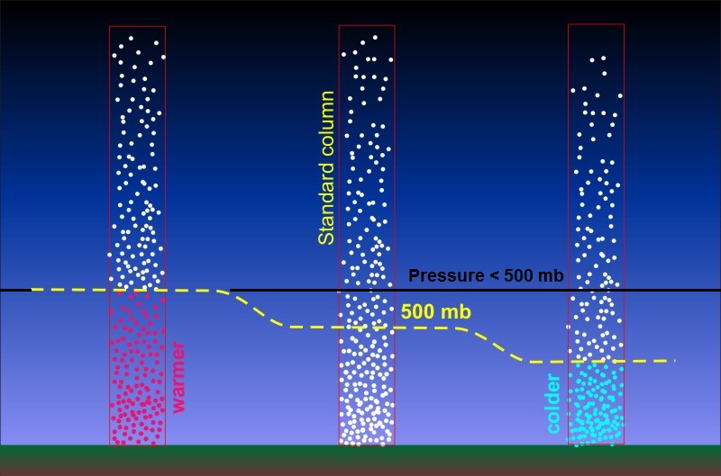
The resulting temperature gradient throughout the troposphere in each hemisphere (warmer at lower latitudes and cooler at higher latitudes) has consequences, namely in helping to create horizontal pressure gradients aloft. To see what I mean, examine the schematic below, which shows the air molecules in three idealized, sealed air columns. Imagine that the column on the left is a warm, low-latitude air column, the column in the middle represents an air column in the middle latitudes, and the column on the right represents a cold, high-latitude air column near the North Pole.
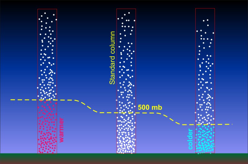
Now, recall that pressure always decreases with increasing height in the atmosphere (the higher you go up, the fewer air molecules are above you). So, pressure decreases with increasing height in each of these air columns, but notice how the pressure has decreased from the value at the surface (likely near 1000 millibars) to 500 millibars at a different altitude in each column. The altitude where the pressure is 500 millibars is highest in the warmest column and is lowest in the coldest column. Because colder air is denser, air molecules huddle closer together at lower altitudes in colder air columns, meaning more of the column's weight is distributed in the lower part of the column. Meanwhile, in warmer columns, air molecules are less tightly packed and more spread out vertically in the column. This observation is along the lines of the balloon experiment we conducted earlier in the course, too. When the burner was turned on and the air warmed up, the number of air molecules in the bottle and balloon didn't change, but the balloon expanded as the air molecules occupied a larger space (the air became less dense as it warmed up).
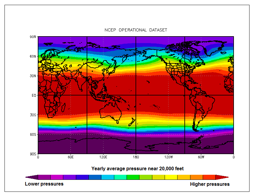
The end result is that pressure decreases more rapidly with increasing height in colder air columns than in warmer ones, which has consequences for horizontal pressure gradients aloft. In the schematic above, note the altitude where the pressure is 500 millibars (marked by the yellow dashed line) in the warm air column. In the colder air columns, the pressure at the same altitude is some value less than 500 millibars (and would be lowest at that altitude on the coldest air column) because fewer air molecules exist above that altitude. So, at any given fixed altitude above the surface in the troposphere, on average, the pressure will be lower in the colder air columns closer to the poles than in the warmer columns closer to the equator, as suggested by this map of approximate yearly average pressure near 20,000 feet.
The map of approximate yearly average pressure near 20,000 feet also shows that horizontal pressure gradients exist over the middle latitudes, resulting in a pressure gradient force aloft that points from low latitudes toward the poles. But, of course, air doesn't flow directly from low latitudes toward the poles in line with the pressure-gradient force. The Coriolis force deflects the air toward the right in the Northern Hemisphere (toward the left in the Southern Hemisphere), which creates a predominant west-to-east flow aloft in the middle latitudes of the Northern Hemisphere. In fact, this flow culminates in something near the top of the troposphere that you may have heard of -- the jet stream, which is a relatively narrow channel of fast winds that blows generally from west to east in the upper troposphere.
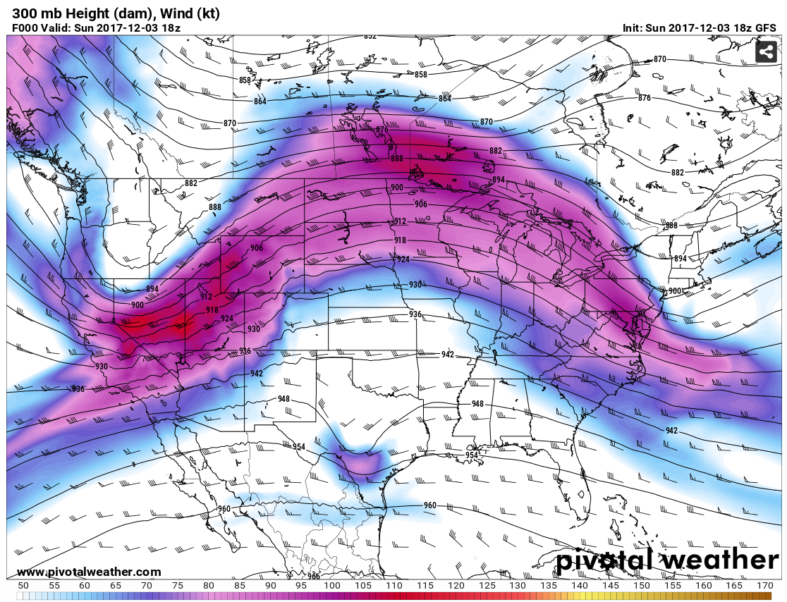
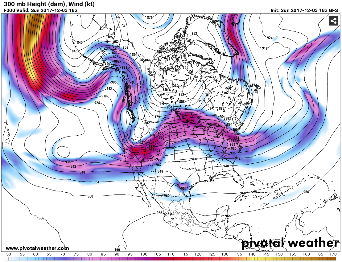
The image above shows a computer model's analysis of wind direction and speed near the top of the troposphere (near 30,000 feet) at 18Z on December 3, 2017. The channel of fastest winds (shaded) blowing generally west-to-east across the United States marks the jet stream. Note that wind speeds in the jet stream at this time were greater than 100 knots (115 miles per hour) in the areas with dark purple and red shading. This general west-to-east flow aloft is the reason why weather systems tend to move from west-to-east across the middle latitudes of the Northern Hemisphere.
But, the jet stream isn't just important for the movement of weather systems. Many commercial airplanes fly at the altitudes where the jet stream typically lies, and its west-to-east flow gives planes traveling from the West Coast toward the East Coast of the U.S. a strong tailwind, resulting in a faster trip and lower fuel consumption. Meanwhile, flights from the East Coast toward the West Coast often have a significant headwind (they're flying against the wind), which increases fuel consumption and results in longer flight times.
When looking at the image above, you may have noticed that the winds aloft don't blow perfectly west to east in the middle latitudes. In fact, the flow looks kind of "wavy," doesn't it? Indeed, we live at the bottom of a dynamic ocean of air, and like in oceans of water, waves of all sizes ripple mainly from west to east across the middle latitudes. If we look at a zoomed-out version of the model analysis of upper-level winds above showing more of the Northern Hemisphere, you can see that the jet stream isn't some nice, tidy, steady current of winds. It has lots of waves and some interruptions. The waves and the changes in wind speed result in some localized accelerations and decelerations of winds aloft, which result in areas of upper-level divergence and convergence. As you've learned, divergence and convergence aloft are important to the formation of low- and high-pressure systems, respectively.
In particular, weather forecasters try to keep tabs on regions aloft where upper-level divergence is occurring because they tend to be regions of active weather, and they can help incite the development of surface low-pressure systems by removing weight from local air columns and reducing surface pressure. In fact, if you've heard a weather forecaster refer to an "upper-level disturbance," they were likely referring to a feature in middle or upper troposphere that was causing divergence aloft and leading to some kind of active weather.
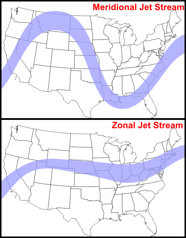
When the jet stream gets particularly wavy, meteorologists call it a meridional pattern because air flow is mostly parallel to meridians (lines of longitude) in some areas. In meridional patterns, areas of divergence (and convergence) aloft become more pronounced, which favors the formation of more intense mid-latitude cyclones. On the other hand, when the jet stream is "flatter" (more west to east), meteorologists call it a zonal pattern. In zonal patterns, areas of divergence (and convergence) aloft tend to be weaker, which favors weaker mid-latitude cyclones.
I've skipped a lot of details here because they're beyond the scope of this course, but I at least wanted you to have a basic idea of why the upper-level pattern is important in understanding and forecasting mid-latitude cyclones. The bottom line is that divergence in the upper-level pattern is a critical part of the formation of mid-latitude cyclones because it works to reduce surface pressure. Although we've covered this idea before, we're going to explore it further in the next section. Read on!