Prioritize...
At the completion of this section, you should be able to describe the general pattern of convergence and divergence within an air column located over steady-state, strengthening, and weakening high- and low-pressure systems. You should also be able to explain how (for example) a surface low pressure system deepens as a result of unequal magnitudes of convergence and divergence.
Read...
Previously, you learned that surface low-pressure systems are essentially "lightweights." Air columns at the center of the low weigh a bit less than surrounding air columns. On the other hand, surface high-pressure systems are "heavyweights." Air columns at the center of the high weigh a bit more than their surrounding air columns. You also learned that air swirls inward toward lower pressure near the surface, and that this convergence adds weight to local air columns (which is a problem for a developing low).
Imagine for a second that air converges into a column over a surface low all the way from the ground up to the tropopause. Using typically observed values for convergence, such a concentration of mass in this column from convergence would result in an increase in sea-level pressure on the order of 500 millibars over the course of 24 hours (I'm skipping the details of the calculations). Given what you know of the typical range for sea-level pressures, you should realize that such a huge pressure change is completely unrealistic. Indeed, typical sea-level pressure changes amount to only a few to several millibars in one day.
Meteorologists have coined a term for cases with "extreme" sea-level pressure changes with rapidly-developing low-pressure systems (such as occasionally happens along the Atlantic Coast during winter). When sea-level pressure in a rapidly-developing low-pressure system decreases by at least 24 millibars in 24 hours, meteorologists call it "bombogenesis" (pronounced "bomb-o-genesis") because of the "explosive" nature of the weather that occurs with such storms (typically very strong winds and heavy precipitation). Such meteorological "bombs," are extreme cases, however, and may only happen a few times a year, even in parts of the globe prone to such rapid development.
Ultimately, however, such huge sea-level pressure tendencies are so rare because low- and high-pressure systems have "checks and balances" that limit their ability to strengthen. For example, recall that divergence aloft removes weight from local air columns and reduces sea-level pressure (acting alone, creating a weak low at the surface). But, in order to avoid a significant depletion of air from local air columns, air spirals in toward low pressure at the surface. This convergence of air in the lower part of the air column works against the divergence aloft and limits its ability to reduce sea-level pressure.
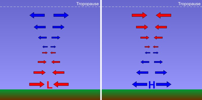
Thus, a much more realistic profile of convergence and divergence in the column of air over the center of a developing low-pressure system has a more balanced look to it. In the figure below, examine the left panel which shows the pattern of convergence and divergence characteristic of a "steady-state" low-pressure system (neither strengthening or weakening). Surface low-pressure systems which are neither strengthening or weakening have convergence near the surface with an equal magnitude of divergence aloft. On the other hand, check out the right panel below which illustrates a realistic profile of the air column at the center of a steady-state high-pressure system. Surface highs have divergence in the lower half of the troposphere and convergence in the upper half of the troposphere.
For sea-level pressure to change, either convergence or divergence must get the upper hand within an air column. For a modestly developing low-pressure system (sea-level pressure decreases in time), the total amount of air diverging from the low's central air column at high levels (a weight loss) must exceed the total amount of air converging into the low's central air column at low levels (a weight gain). Thus, there must be a net divergence and a net loss of weight, allowing the sea-level pressure to decrease and the low to "deepen" (intensify). On the other hand, for a developing high-pressure system (sea-level pressure increases in time), the total amount of air converging into the high's central air column at high levels (causing weight gain) must exceed the total amount of air diverging from the column at low levels (a weight loss). There must be a net convergence into the column and a resulting weight gain.
Consider the following two graphs below. These graphs show a plot of convergence and divergence with height. Convergence is shaded in red while divergence is shaded in blue. To figure out the net convergence or divergence, compare the sizes of the shaded areas. If the blue area is greater than the red area, then there is more mass divergence out of the column than mass convergence into the column. If the red area is greater than the blue area, then there is more mass convergence into the column than divergence out of the column.
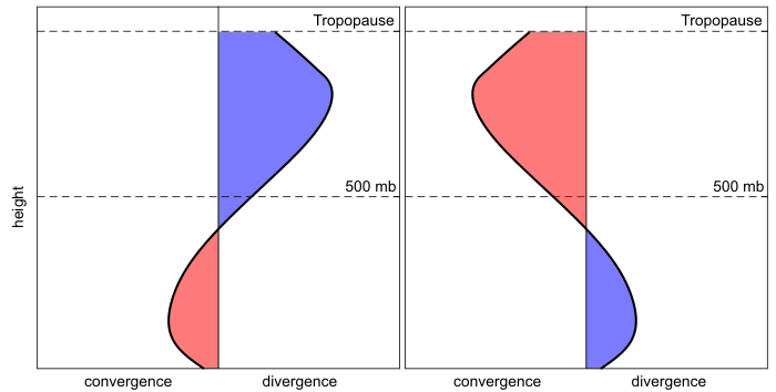
In the plot (above) on the left, notice first that the divergence and convergence profile is associated with a surface low pressure system. How do we know? We know that air swirls in and converges toward the center of low pressure in the lower atmosphere, and this profile shows low-level convergence. But, also notice that the total divergence aloft is much larger than the total convergence, so the column will lose weight over time. That weight loss means that sea-level pressure will decrease and the low-pressure system is deepening (becoming stronger).
We know that the graph on the right above is associated with a surface high-pressure system because there's divergence in the lower part of the atmosphere. But, also notice that the region of convergence aloft is larger than the region of divergence, so the column will gain weight over time. This means that the sea-level pressure will rise in time, further strengthening the high-pressure system.
On the other hand, what if there was a low-pressure system in which the convergence in the lower half of the troposphere was exceeding the divergence aloft? The low would weaken in time because the central air column would be gaining more weight from convergence than it was shedding via divergence aloft. A similar argument holds true for a high that is shedding more weight through divergence in the lower half of the troposphere than it is gaining from convergence aloft. Such a high would weaken in time because sea-level pressure would decrease.
The bottom line is that whenever you're thinking about changes in sea-level pressure, you need to think about weight management. Obviously, divergence and convergence in the upper-half of the troposphere play a pivotal role in the fate of surface low- and high-pressure systems, so weather forecasters are always looking at upper-air patterns to spot regions of convergence and divergence. To give you more of a three-dimensional view of how the vertical patterns of convergence and divergence with low- and high-pressure systems fit together, check out the schematic below.
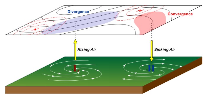
In particular, forecasters are always on the lookout for waves and accelerations or decelerations in the winds aloft, often referred to as "upper-level disturbances" which cause divergence aloft (marked by the blue shaded area in the image above), which cause air columns to shed weight and sea-level pressures to decrease. The resulting low-level convergence and rising air frequently causes the clouds and precipitation typically associated with low-pressure systems. On the other hand, regions of convergence aloft cause sea-level pressures to increase. The resulting low-level divergence and sinking air typically leads to the calm and mostly clear conditions associated with surface high-pressure systems.
Key Concepts to Remember
- "Steady-state" highs and lows have equal amounts of divergence and convergence in their central air columns, resulting in no change in sea-level pressure.
- A strengthening low-pressure system (sea-level pressure decreasing with time) has upper-level divergence that exceeds low-level convergence, resulting in weight loss in the central air columns.
- A weakening low-pressure system (sea-level pressure increasing with time) has low-level convergence in the column that exceeds upper-level divergence, resulting in weight gain in the central air columns.
- A strengthening high-pressure system (sea-level pressure increasing with time) has upper-level convergence in the column that exceeds low-level divergence, resulting in weight gain in the central air columns.
- A weakening high-pressure system (sea-level pressure decreasing with time) has low-level divergence in the column that exceeds upper-level convergence, resulting in weight loss in the central air columns.
So, it's all about weight management, and ultimately low-pressure systems need a source of upper-level divergence to form and thrive, while high-pressure systems need a source of upper-level convergence to form and thrive. But, for these systems (particularly low-pressure systems) to really develop, they need other ingredients, too. Read on!