Prioritize...
After completing this section, you should be able to discuss the ingredients needed for a mid-latitude cyclone to form and thrive. You should also be able to discuss the resulting temperature advections caused by a mid-latitude cyclone's circulation, define the warm sector, and discuss the conditions that bring about the demise of a mid-latitude cyclone.
Read...
Some low-pressure systems become legendary. When mid-latitude cyclones are particularly strong in winter, snowstorms can leave entire regions crippled for days or weeks. The fierce weather and resulting disruption (and perhaps damage and loss of life) leave such an impression that tales of their ferocity get passed on through generations. Have you ever heard of, or did you live through, any of these historic mid-latitude cyclones?
- The ”Children's Blizzard“ of 1888
- The ”Great Appalachian Storm“ of 1950
- The ”Great Blizzard“ of 1978
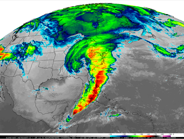
- The ”Storm of the Century“ (Blizzard of 1993)
- The ”Blizzard of 2016“
If you read any of the descriptions of these historic storms, perhaps you noticed a couple of things. First, a few of them impacted the East Coast of the United States. Second, several of the descriptions reference "temperature gradients" or quick changes from warmth to cold. The description of the "Children's Blizzard" of 1888 is particularly poignant in this regard. Residents of Minnesota described a "beautiful mid-winter day" that was "warm enough to melt the snow." But, when frigid, Arctic air arrived rapidly in the afternoon, temperatures quickly plunged below 0 degrees Fahrenheit, with piercing winds and heavy snow. Hundreds of people died because they were caught unprepared out in the storm (it's called the "Children's Blizzard" because many of its victims were school children who were trying to make it home from school).
The mention of temperature changes and the frequent appearances of East Coast storms on the list above isn't a coincidence. The East Coast is an area that can be prime for explosive cyclone development in winter. But, just what ingredients are necessary for the formation and development of formidable mid-latitude cyclones?
- A source of upper-level divergence to reduce weight of local air columns (an "upper-level disturbance")
- A large surface temperature gradient (in other words, a front)
That's it! The basic ingredients for a mid-latitude cyclone are an upper-level disturbance that causes divergence aloft and a surface front (remember that fronts mark boundaries between contrasting air masses, so they naturally have large temperature gradients). More specifically, a mid-latitude cyclone is born when an upper-level disturbance passes over a surface stationary front, creating a weak area of low pressure along it as divergence aloft reduces the weight of local air columns.
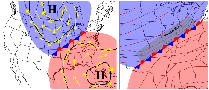
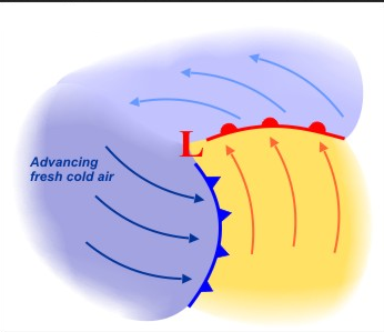
Imagine an idealized stationary front with a colder air mass north of the front and a warmer air mass to the south. When divergence aloft from an upper-level disturbance creates a weak surface low, a circulation develops. How? Remember that the pressure-gradient force and Coriolis force combine to create a counterclockwise circulation around low pressure in the Northern Hemisphere, while friction near the surface causes winds to cross local isobars in toward lower pressure. The circulation begins to move the edges of the air masses as the southerly flow east of the low tends to cause cold air to retreat northward and warm air to begin advancing northward. Meanwhile, on the western side of the low, colder air starts to plunge southward.
So, the stationary front is no longer "stationary" as air begins to move around the low. East of the low, a warm front (which marks the retreat of colder air) develops as cold air retreats northward, allowing warm air to advance. Meanwhile, a cold front (which marks the leading edge of advancing cold air) forms west of the low as cold air begins to plunge southward. Gradually, the cold front moves counterclockwise around the low as colder air wraps around its southern side (depicted on the right above), helping to form a well-defined warm sector (the area ahead of the cold front and south of the warm front for a cyclone in the Northern Hemisphere), where it's relatively warm and often humid, especially in the warmer months. When a cold front passes your location, the transition from the warm sector to the colder air behind the cold front can be really dramatic!
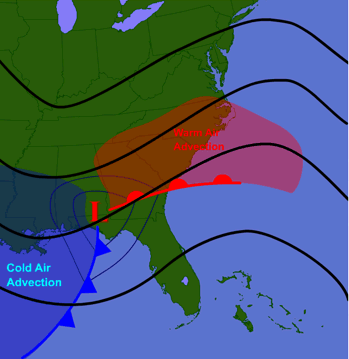
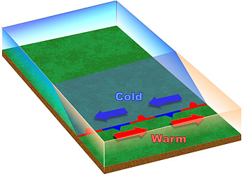
Ultimately, the low's circulation results in a pattern of temperature advection (recall that temperature advection is the movement of warm or cold air by the wind) similar to what's shown in the idealized schematic on the right. The strongest warm advection occurs north of the warm front, while the strongest cold advection occurs behind the cold front. These temperature advections help to modify the upper-air pattern (depicted by the thick, black contours on the schematic) and strengthen the upper-level disturbance that causes the upper-level divergence. With greater upper-level divergence, sea-level pressure decreases further and the low gets stronger, which strengthens pressure gradient, the low-level winds, and the temperature advections. Stronger temperature advections further strengthen the upper-level disturbance, and so on. Essentially, strong temperature gradients are required for mid-latitude cyclone development because the temperature advections play a key role in a positive feedback process that strengthens the cyclone (the cyclone strengthens itself).
But, as you know, the atmosphere has checks and balances that limit the strength of the cyclone. For example, as the surface low strengthens, the stronger winds in the lower troposphere create stronger convergence in toward the center of the surface low (which adds weight to local air columns), thereby slowing the low's intensification somewhat.
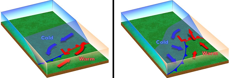
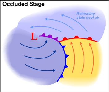
Of course, all good things must come to an end, and a low can't just strengthen forever. What brings an end to a mid-latitude cyclone's life? First of all, the main source of upper-level divergence eventually moves away. Once that happens, air columns near the center of the low are gradually overwhelmed by convergence and sea-level pressures increase. Secondly, the low ends up getting somewhat separated from the large temperature gradients associated with the fronts. This separation occurs late in the cyclone's life, called "occlusion" (or "the occluded stage"). During the occluded stage, you'll see a purple occluded front on surface weather maps, which marks the boundary between "stale" cool air north of the warm front, and the "fresher" cold air being ushered in behind the cold front. Note how in this schematic of the occluded stage, the low is no longer located in the zone of largest temperature contrasts as it was earlier in the low's life.
So, removed from strong surface temperature gradients and lacking upper-level divergence, the low weakens and dies, but it has done its job. You might be asking yourself, "A mid-latitude cyclone has a job?" Indeed, it does! By transporting warmer air poleward and colder air equatorward, the low has helped to reduce horizontal temperature contrasts between cooler high latitudes and warmer low latitudes. In other words, mid-latitude cyclones help the atmosphere strive for balance by reducing hemispheric temperature gradients.
The importance of large temperature gradients in the formation and development of mid-latitude cyclones explains why so many "big" storms end up forming along the East Coast of the United States. In the winter, there's often a naturally large temperature gradient near the coast. The water of the Atlantic, which has a high heat capacity as you may recall, tends to be warmer than the chilly land in the Mid-Atlantic and Northeast U.S. The resulting naturally large temperature gradient near the coast creates fertile breeding grounds for strong mid-latitude cyclones.
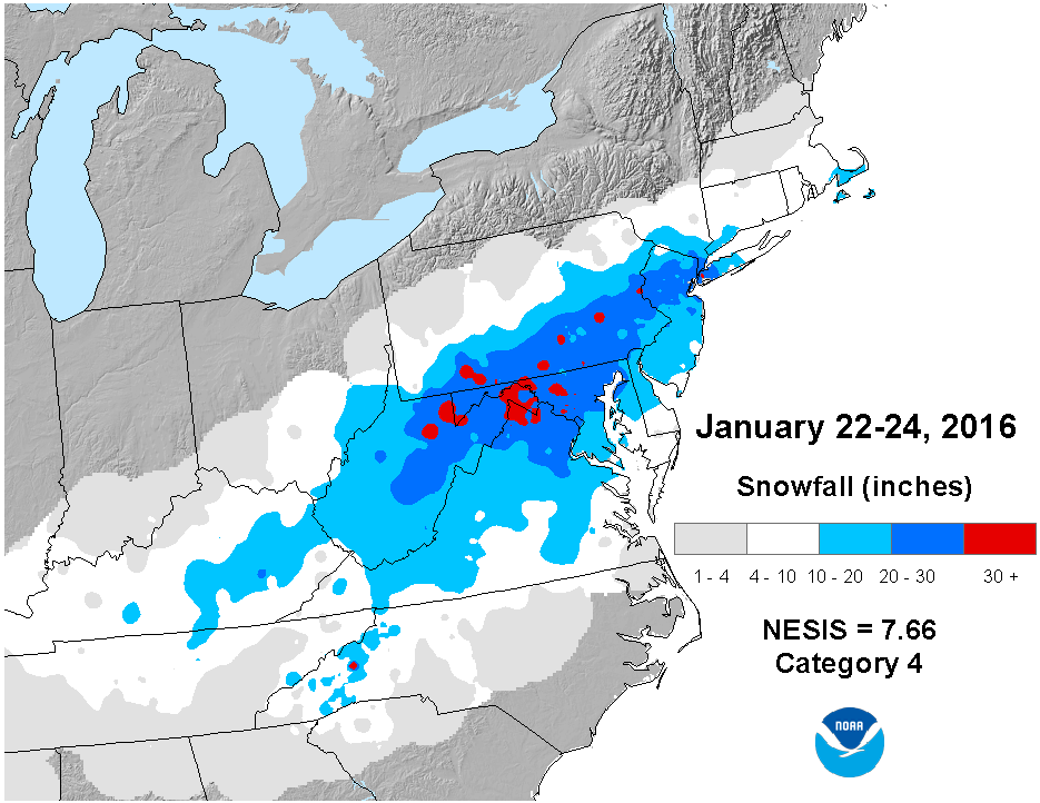
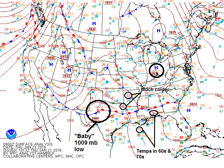
One such storm was the "Blizzard of 2016," which was actually "born" in Texas as a weak area of low pressure along a stationary front. As the low developed and strengthened on its path up the East Coast, it dumped more than 30 inches of snow on parts of West Virginia, Virginia, Maryland, and Pennsylvania. To get a sense for the birth, life, and death of a mid-latitude cyclone, check out this animation of surface maps spanning the life of the Blizzard of 2016. Note the initial set up -- a "baby" 1009 millibar low along a stationary front in Texas, separating warm Gulf-of-Mexico air (temperatures in the 60s and 70s) from a much colder air mass anchored by the high pressure over Ohio. Over the course of a day, the low becomes much stronger, with a stronger pressure gradient and notable cold and warm advection. By the time the storm was off the Mid-Atlantic coast, it was a fierce 987-millibar occluding low. This storm went from a "baby" low over Texas to a dying low over the Atlantic in a little less than three days (most mid-latitude cyclones last for a few days to a little more than a week).
But, what causes the fierce weather with strong mid-latitude cyclones? The winds are largely explained by a strong pressure gradient. But, what about the heavy precipitation? It all comes down to rising air, and up next, we'll start looking at various sources of rising air associated with low-pressure systems. As it turns out, fronts play an important role in the pattern of rising air with mid-latitude cyclones, so we need to examine fronts further. Read on.