Motivate...
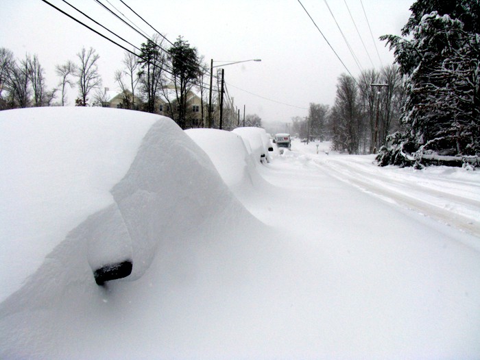
At one point or another, you've probably heard a weather forecaster use the term "low-pressure system," but perhaps you've never heard it called by its formal name -- mid-latitude (or extratropical) cyclone. Indeed, as long as you live in the middle latitudes (where the United States, most of Canada, Europe, and Asia lie in the Northern Hemisphere), the phrase "low-pressure system" really refers to a mid-latitude cyclone. Mid-latitude cyclones are responsible for much of the "active" weather that you experience from day to day. If it's raining, snowing, very windy, etc., there's a good chance that a mid-latitude cyclone is involved somehow! In the winter, weather with mid-latitude cyclones can be especially dramatic. For example, check out the photo below, taken after the "Snowmageddon" (not a technical term) storm that struck the mid-Atlantic states on February 5-6, 2010. When the storm finally moved out to sea, many of the affected residents emerged to find snow totals between 20 and 39 inches!
However, impacts from mid-latitude cyclones are not just limited to winter weather. In the springtime, another threat emerges. Strong mid-latitude cyclones moving through the central United States can provide ideal conditions for large outbreaks of severe weather, including tornadoes. Indeed, that was the case when a strong mid-latitude cyclone swept across the central and eastern U.S. from April 25-28, 2011. Over the three-day period, 358 tornadoes were spawned by thunderstorms associated with this strong low pressure system.
So, it's pretty easy to see why weather forecasters would be interested mid-latitude cyclones! Much of what we know about how mid-latitude cyclones work is based on a model (called the "Norwegian Cyclone Model") developed by Jacob Bjerknes and Halvor Solberg in 1922, and there's no doubt that this model has shaped the way that meteorologists understand the weather that occurs in the middle latitudes.
While we experience the weather that occurs with mid-latitude cyclones at the surface of the earth, in reality, mid-latitude cyclones are complex, three-dimensional systems. We'll talk a little bit about some of the mechanisms aloft that drive the formation and evolution of mid-latitude cyclones, but I'll spare you most of the gory details. Instead, we'll focus mostly on the aspects of mid-latitude cyclones that people experience on a regular basis. In particular, we'll talk more about air masses and fronts and focus on the types of weather that often occur with various types of fronts. We'll also explore how mid-latitude cyclones can cause a variety of hazardous winter weather and discuss some important winter weather safety tips.
This lesson will require you to put some "pieces together" from previous lessons, including convergence and divergence, air masses, fronts, gradients, and temperature advection, so we'll do a little reviewing along the way, too. Of course, if you feel rusty on any of these topics, don't hesitate to go back and review. Up first, I want to establish a framework about why mid-latitude cyclones exist in the first place. Let's get started!