Prioritize...
At the completion of this section, you should be able to define freezing rain and sleet. You should also be able to describe the temperature profile in the lower atmosphere that causes the formation of each (in addition to the temperature profiles that cause snow and rain), as well as generally where each type of precipitation is common within the context of a winter mid-latitude cyclone.
Read...
I'll start this section with something that may shock you. Imagine it's a hot, humid summer day and you get stuck outside in an afternoon downpour of rain. While you're getting soaked, it's probably snowing within five miles of your location. It's true! It's probably snowing five miles above you! Actually, most rain originates from snow, even in the summertime! Most precipitation begins as ice crystals (also called snow crystals), which are often shaped like columns or hexagonal plates. Ice crystals grow high up within the clouds where it's very cold, so even when it's raining at the surface, it's usually snowing somewhere up in the clouds.
That background helps us understand how many winter storms have more than snow in their arsenal of weather weapons, including freezing rain, sleet, steady rain, and thunderstorms. While most everyone knows what snow and rain are, have you ever thought about the conditions that cause each to fall? It's not all about conditions at the surface of the Earth! For starters, when temperatures throughout the entire troposphere are less than than the melting point of ice and when clouds are sufficiently cold enough for ice crystals to grow, only snow can reach the ground.
But, what about when temperatures aren't lower than the melting point of ice throughout the entire troposphere? Well, when snowflakes fall through a layer of air that is warmer than the melting point of ice (temperatures greater than 0 degrees Celsius, or 32 degrees Fahrenheit), snowflakes start to melt. Assuming that temperatures in the "warm" layer are a few degrees above the melting point of ice, snowflakes will melt completely into raindrops, and rain will be the observed precipitation type at the surface if the "warm" layer extends down to the ground.
Simple enough, right? But, what about other precipitation types like sleet and freezing rain (the two most frequently confused types of wintry precipitation)? Sometimes in the atmosphere, a "warm-air sandwich" of sorts develops. In other words, there can be a layer of very cold air near the ground, a slab of "warm air" a few thousand feet aloft, and cold air above the warm slab. When a "warm-air sandwich" develops, that's when sleet and freezing rain enter the picture. Check out the short video below (2:51) to see the vertical temperature profiles associated with sleet and freezing rain (and rain and snow, too).
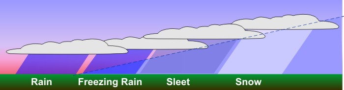
Let’s look at how different vertical temperature variations can result in different types of precipitation at the surface of the earth. I’ll start with a straightforward case, depicted on the left: When temperatures throughout the entire troposphere are less than the melting point of ice and clouds are sufficiently cold enough for ice crystals to grow, only snow can reach the ground.
But, for scenarios in which temperatures aren’t cold enough to sustain snowflakes all the way to the ground, the pink layer represents air with temperatures greater than the melting point of ice – that’s 0 degrees Celsius, or 32 degrees Fahrenheit. So, over here on the right, when snowflakes fall through a layer of air that is warmer than the melting point of ice, snowflakes start to melt. Assuming that temperatures in the "warm" layer are a few degrees above the melting point of ice, snowflakes will melt completely into raindrops, and rain will be the observed precipitation type at the surface if the "warm" layer extends down to the ground.
That seems simple enough, but sometimes in the atmosphere, a "warm-air sandwich" of sorts develops. In other words, there can be a layer of very cold air near the ground, a slab of "warm air" a few thousand feet aloft, and cold air above the warm slab. When a "warm-air sandwich" develops, that's when sleet and freezing rain enter the picture.
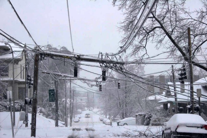
Now, when the layer of cold air near the ground with a temperature less than 0 degrees Celsius isn't thick enough to refreeze the rain drops, freezing rain is the result. When freezing rain is observed, liquid rain drops don't have time to freeze in the layer of cold air near the ground, so they become "supercooled," which means that they're liquid that exists at temperatures less than the melting point. These supercooled raindrops freeze on contact with cold objects such as untreated roads and sidewalks, power lines, and trees. Freezing rain creates a slippery glaze, and when heavy, it can produce devastating ice storms as the weight of ice accumulating on tree branches and power lines brings them down.
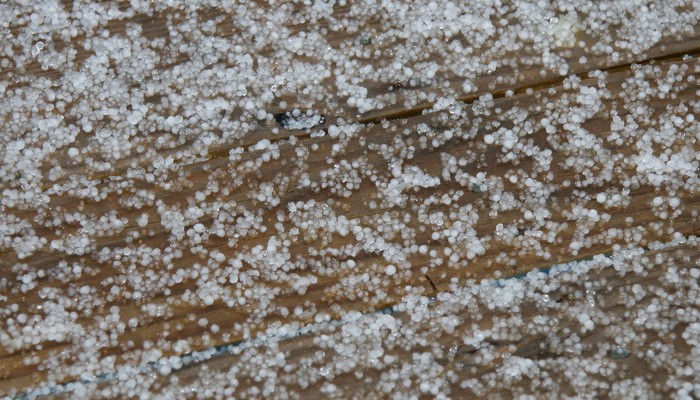
Ultimately, when the slice of cold air next to the ground is relatively thick, the rain or partially melted snowflakes can refreeze into ice pellets, called sleet (assuming that snowflakes completely or partially melt when they fall through a warm layer above the relatively thick slice of cold air). Sleet (shown in the image on the right) tends to make a tapping noise and bounce when it hits objects. The formation of sleet requires that the slice of air next to the ground is thick and cold enough to refreeze raindrops while still in the air because raindrops don't refreeze immediately when entering the bottom slice of cold air (it takes time).
When the layer of cold air near the ground (temperature less than 0 degrees Celsius) isn't thick enough to refreeze the rain drops, freezing rain is the result. When freezing rain is observed, liquid rain drops don't have time to freeze in the layer of cold air near the ground, so they become "supercooled," which means that they're liquid that exists at temperatures less than the melting point. These supercooled raindrops freeze on contact with cold objects such as untreated roads and sidewalks, power lines, and trees.
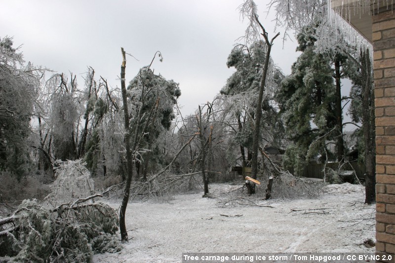
Freezing rain creates a slippery glaze, and when heavy, it can produce devastating ice storms as the weight of ice accumulating on tree branches and power lines brings them down. Indeed, after a devastating ice storm, it can take days (or longer) for power to be restored, which leaves many without heat for their homes during very cold weather. The photograph above, which was taken in the aftermath of an ice storm on January 28, 2009, gives a good example of the carnage that an ice storm can bring (more photos are linked in the caption).
So, ultimately, the surface temperature only partly determines the type of precipitation that is observed at the ground, and sometimes even with very cold air near the surface, the precipitation type may not be snow. Freezing rain, for example, has been observed at surface temperatures less than 10 degrees Fahrenheit. If you are wondering why it just wouldn't snow at such low temperatures, keep two things in mind. Near the leading edge of an Arctic air mass, the depth of the cold air is very shallow. That means there's much warmer air above the thin slice of Arctic air next to the ground (producing the "warm air sandwich"). Second, given the slab of "warm" air above the thin slice of Arctic air, the destiny of snowflakes is a foregone conclusion -- they melt. Once snowflakes melt into raindrops, they can't turn into snowflakes again. Snowflakes are not frozen rain drops! Because the cold air layer is thin, rain drops do not have a chance to freeze while in the air, so they freeze on contact with the very cold surface.
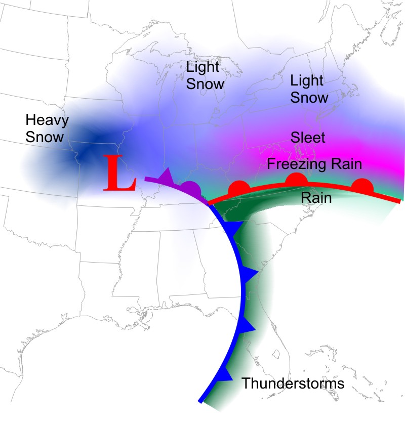
How do "warm-air sandwiches" develop in the context of mid-latitude cyclones? Overrunning is a common culprit, as warmer air overruns cold air near the surface north of the warm front. In the colder months, the overrunning north of the warm front often brings a mixed bag of wintry precipitation types, and this general template for the distribution of wintry precipitation around a mid-latitude cyclone will help you to get a rough idea for the locations of the various types of wintry precipitation relative to the low's warm front. Generally, the "line" that separates snow from other forms of wintry precipitation lies north of a mid-latitude low's warm front, but I caution you that this template is highly generalized. The details vary from storm to storm. Some storms produce only snow, while others produce only rain. Others can produce all precipitation types. Determining exactly where the lines between snow, sleet, freezing rain, and rain will occur can be one of the toughest forecasts a meteorologist has to make.
The cross section above shows how overrunning can create a variety of precipitation types north of the warm front. Warm air cools as it glides upward along the frontal zone, and areas farthest north have the best chance of having temperatures low enough to support snow surviving all the way to the surface. A bit farther south (closer to the warm front), the overrunning can create a thin melting layer above the cold wedge, but the cold wedge near the surface is thick enough for raindrops to freeze into sleet before reaching the surface. Even closer to the warm front, the melting layer is deeper, and the cold wedge near the surface isn't thick enough for raindrops to refreeze before hitting the ground, so freezing rain results as supercooled raindrops freeze on contact with the surface. Finally, south of the warm front in the warm sector is the most likely region for warm air to extend all the way to the ground (commonly resulting in rain). Again, however, I remind you that this template is very general, and every storm is a little bit different.
Know your precipitation types!
- Snow: Ice crystals that fall to the surface when the entire atmospheric column is sufficiently cold
- Sleet: Ice pellets that form as raindrops refreeze before reaching the surface. Sleet tends to bounce on contact.
- Freezing Rain: Supercooled raindrops that freeze on contact with cold surfaces (untreated pavement, trees, power lines, etc.). Freezing rain creates a dangerous, slippery, icy glaze.
- Rain: Liquid water drops that fall to the surface (which typically form from melted snowflakes)
Forecasting exactly where and when precipitation types will change in a winter storm can be extremely challenging. Sometimes, small distances (maybe as little as several miles) separate an area that gets buried with heavy snow from an area that gets less snow, but instead gets periods of freezing rain and sleet. The exact details of where and when those changes will occur are not always obvious!
With the potentially dangerous winter weather that mid-latitude cyclones can bring, from snow, sleet, and freezing rain, to bitter cold and strong winds, I think it's important that we cover some winter weather safety basics before we wrap up this lesson. Read on.