Delta Morphologies and Driving Processes
Variations in delta morphology tell us something about the processes that cause and drive the evolution of deltaic environments. Globally, it is widely accepted that there are three end-member morphologies of deltas that reflect the relative influence of wave energy and tidal energy in the receiving basin or sediment input by the source river into the receiving basin. On a ternary plot, these three end members each represent one apex of the plot, and all deltas fall somewhere on this plot. Deltas that are primarily the result of high rates of sediment input tend to be elongated because of their rapid outbuilding associated with high rates of deposition into the receiving basin. Wave-influenced deltas have smooth, often arcuate shorelines with numerous ridges that reflect the longshore transport of river-delivered sediment by the high wave energy. Tidally influenced deltas have numerous shoreline perpendicular tidal passes and tributaries, with sediment bodies aligned parallel to the direction of tidal exchange.
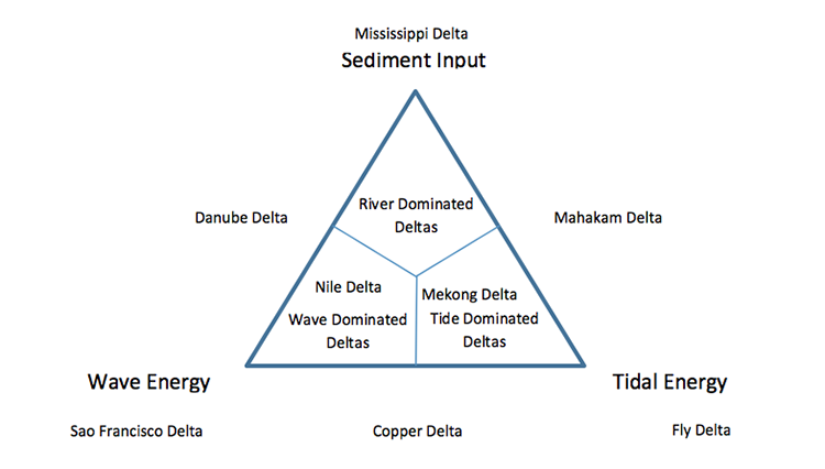
Ternary plot showing the relative influence of sediment input, wave energy, and tidal energy on delta morphology and where some of the Earth’s deltas plot within this scheme.
Credit: after Galloway, 1975
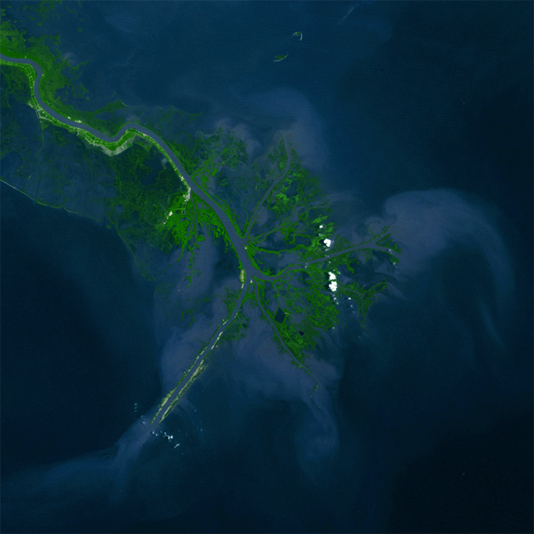
Satellite image of the Mississippi River delta that has built into the northern Gulf of Mexico along the south-central United States. The elongated, digitate form of the modern locus of deposition is the result of high sediment supply by the Mississippi River and low wave and tidal energy in the Gulf of Mexico. Like many other deltas, the Mississippi River is currently in a state of deterioration because of relative sea level rise and reduced sediment loads resulting from dams that capture sediment farther upstream.
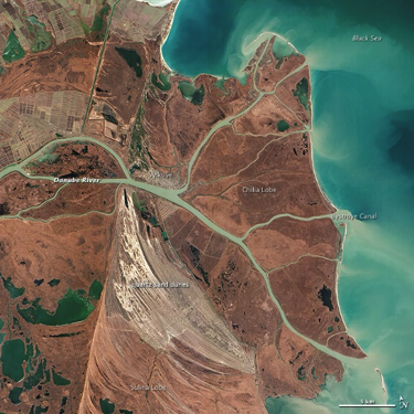
Satellite image of the Danube River delta where the Danube River, the largest European river, empties into the Black Sea. The delta has been occupied by humans since the end of the Stone Age. Note the generally smooth coastline of the delta and the presence of ridges (lower half of delta) and barrier islands that suggest the front of the delta has been shaped by wave processes. The ridges represent alongshore accumulation by longshore transport processes.
Credit: NASA
Rotated view of the Fly River delta of Papua New Guinea in the lower right-hand corner, where the Fly River empties into its receiving basin. The delta morphology is characteristic of tidally influenced deltas. This delta is mesotidal with a tide range of approximately 3.5 m at the mouth to 5 m farther inland.
Credit: NASA
