
Deltas in Crisis
During the last decade, a substantial amount of concern has arisen regarding the health of the planet's major deltas. Over-exploitation of deltaic resources by humans, the introduction of pollutants, and excess nutrients to the rivers, as well as the management of river water that feeds deltas has severely damaged the sensitive environments of many deltas. Additionally, reduced sediment loads in many deltas, because of the construction of dams, coupled with global sea level rise and/or local land subsidence has resulted in widespread loss of deltaic wetlands and fronting sandy barrier shorelines. Because deltaic plains are so heavily relied upon by humans and, in some cases, are densely inhabited by humans, there are, for some deltas, widespread efforts to try to halt coastal erosion and environmental damage.
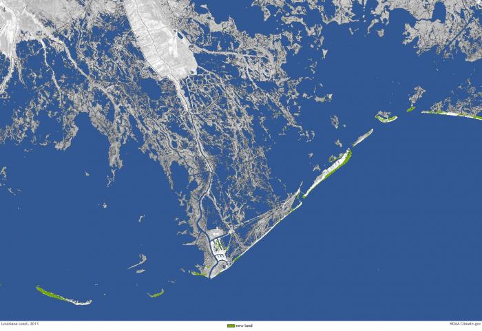
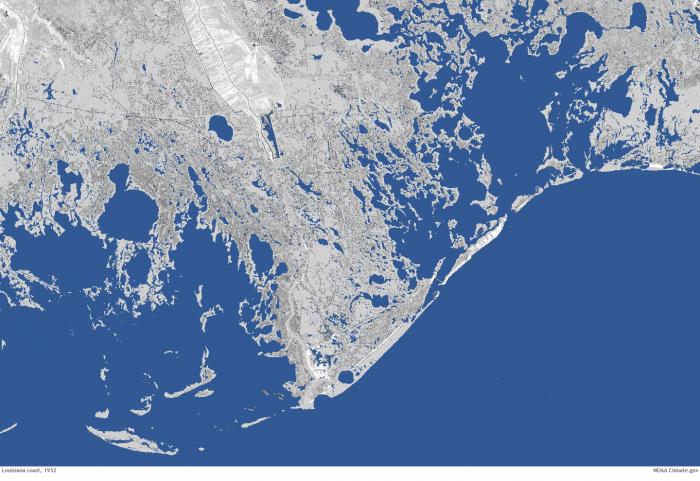
For example, the wetlands of the Mississippi River delta have undergone substantial change during the last century, with large areas of wetlands converted to open water because of relative sea level rise and erosion by storms. The rate is just staggering, with a football field of wetlands vanishing into open water every 30 minutes! The loss of wetlands across the delta is so severe that communities and infrastructure that were once separated from the open Gulf of Mexico by wetlands are now exposed to open marine water and have become more vulnerable to the damaging effects of storm surge. As a result, the state of Louisiana has developed a series of plans to build new land and infrastructure that would help reduce the net loss of land. The staggering change between 1932 and 2011 can be seen in the two satellite images below.
More Information
- For more information on deltas, see Delta.
- For more information on issues with and plans to restore the Mississippi River Delta in Louisiana, see Restore the Mississippi River Delta.