
Tides
People have been fascinated with tides throughout history, with various aboriginal legends dating back tens of thousands of years accounting for this phenomenon. One Native American legend tells of a raven who wanted to alter the depth of the oceans to make it shallower and therefore make more food accessible for his people, while Australian Aborigines have legends that speak of the moon filling with water while it was waxing, and how water drained back out of the moon as it waned, demonstrating the understanding that the lunar cycle was associated with water levels of the ocean.
Our current understanding of the tides can be explained using Sir Isaac Newton’s universal law of gravitation. He proved that the gravitational attraction between two bodies is directly proportional to mass and inversely proportional to the square of the distance between them. This is the case with the relationship between the sun, the moon, and the Earth. While the moon is relatively small, it is also relatively close to Earth and exerts a gravitational pull on the Earth’s surface that is stronger than that of the sun, which is much larger but also much further away. It is this gravitational attraction of both the moon and the sun to the Earth that causes the periodic rising and falling of the ocean’s surface that we call tides.
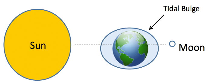
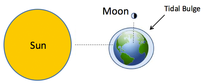
Tidal “Bulge”
The gravitational attraction between the moon and the Earth causes the water in the oceans, which is fluid and mobile, to be pulled towards the moon. This creates a “bulge” in the ocean that is closest to the moon and as the Earth rotates, the location of the waters that are affected, change. Picture the moon as a magnet that draws the water towards it. This movement of water towards the moon is counteracted by the force of inertia, the force that tends to cause a moving object to continue moving in a straight line. This is what balances out the movement of our oceans, but because the gravitational pull is stronger, the resultant force causes our tides. The sun also has this effect, but due to the vast distance from Earth, plays a smaller role.
Spring and Neap Tides
We sometimes hear on the news during a coastal storm that the effects on the shoreline will be more severe due to especially high tides. This is due to the position of the moon and the sun in relation to the Earth and the resulting gravitational attraction at various stages in the lunar cycle.
When the moon is in a position relative to the Earth where it is pulling in a direction that is in the same axis as the sun (new and full moon), both bodies are exerting a force on the Earth that is cumulative. This is called conjunction, and because these forces are both working to pull the Earth’s surface in the same directional axis, we experience higher high tides and lower low tides than we see throughout the month at a given location. This is the period during the lunar cycle that we experience spring tides.
When the moon is in a position that is at right angles to the sun, the gravitational pull of the two bodies is working in opposing directions on the Earth’s surface. This is when the gravitational forces of the sun and the moon are working against each other and we experience moderate changes in water levels. We refer to this period in the lunar cycle as neap tides that occur during quarter moons.
The difference during spring and neap tides is evident in the tide graphs for a tidal gauge in Halifax Harbour shown for Spring tide and Neap tide. This tide gauge is measuring water levels at the same location. However, during a spring tide the high water is almost 6.5 ft while during the neap tide, the high water is approximately 4.8 ft. The low tide during the spring tide is 0.2 ft and during the neap tide is 1.5 ft. The highs and lows during the full or new moon are much more pronounced than they are during the quarter moons. That is why a storm event paired with a spring tide may cause more serious damage along a coastline than a storm event paired with a neap tide.
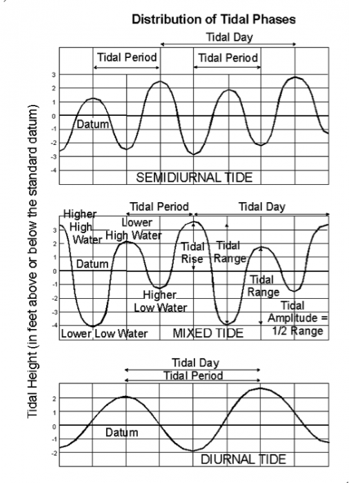
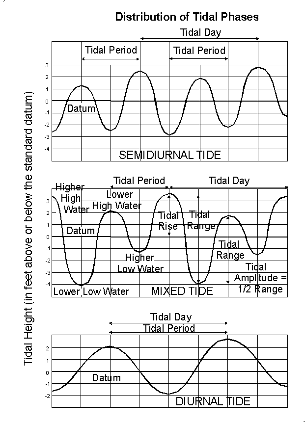
Tidal Graphs
Tidal Cycles
A tidal cycle is one high tide plus a successive low tide. Due to land masses, the movement of water moving around on the Earth's surface due to tides is impeded. The resulting tidal cycle or pattern, therefore, depends on geographic location. There are three basic types of tidal cycles that are globally distributed.
Semi-diurnal Tides
This is the most common tidal pattern, featuring two highs and two lows each day, with minimal variation in the height of successive high or low waters, and is very common along much of the east coast of North America.
Diurnal Tides
There is only a single high and a single low during each tidal day; successive high and low waters do not vary by a great deal. Such tides occur, for example, in the Gulf of Mexico, the Java Sea, and in the Tonkin Gulf.
Mixed Tides
These are characterized by wide variation in heights of successive high and low waters, and by longer tide cycles than those of the semidiurnal cycle. Such tides occur, for example, along the U.S. Pacific coast and many Pacific islands.
Semidiurnal Tide
Tidal period: Time between high tide peak (lower) to high tide peak (higher) or low tide trough (lower) to low tide trough (higher).
Tidal day: Time between higher high tide peak to higher high tide peak.
Mixed Tide
Tidal period: time going through the peak of lower high water, higher low water, and the peak higher high water.
Tidal day: From the peak of higher high water, to lower low water to lower high water to higher low water back to the peak of higher high water.
Diurnal tide
Tidal period=tidal day: between the peaks of high tide
