When people who work with maps and aerial images use the word "scale," they usually are talking about the sizes of things that appear on a map or air photo, relative to the actual sizes of those things on the ground.
Map scale is the proportion between a distance on a map and a corresponding distance on the ground:
(Dm / Dg).
By convention, the proportion is expressed as a "representative fraction" in which map distance (Dm) is reduced to 1. The proportion, or ratio, is also typically expressed in the form 1 : Dg rather than 1 / Dg.
The representative fraction 1:100,000, for example, means that a section of road that measures 1 unit in length on a map stands for a section of road on the ground that is 100,000 units long.
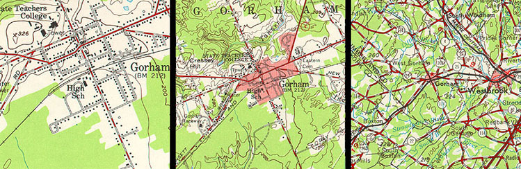
If we were to change the scale of the map such that the length of the section of road on the map was reduced to, say, 0.1 units in length, we would have created a smaller-scale map whose representative fraction is 0.1:100,000, or 1:1,000,000. When we talk about large- and small-scale maps and geographic data, then, we are talking about the relative sizes and levels of detail of the features represented in the data. In general, the larger the map scale, the more detail is shown. This tendency is illustrated below in Figure 2.5.1.
One of the defining characteristics of topographic maps is that scale is consistent across each map and within each map series. This isn't true for aerial imagery, however, except for images that have been orthorectified. As discussed in Chapter 6, large scale maps are typically derived from aerial imagery. One of the challenges associated with using air photos as sources of map data is that the scale of an aerial image varies from place to place as a function of the elevation of the terrain shown in the scene. Assuming that the aircraft carrying the camera maintains a constant flying height (which pilots of such aircraft try very hard to do), the distance between the camera and the ground varies along each flight path. This causes air photo scale to be larger where the terrain is higher and smaller where the terrain is lower. An "orthorectified" image is one in which variations in scale caused by variations in terrain elevation (among other effects) have been removed.
You can calculate the average scale of an unrectified air photo by solving the equation Sp = f / (H-havg), where f is the focal length of the camera, H is the flying height of the aircraft above mean sea level, and havg is the average elevation of the terrain. You can also calculate air photo scale at a particular point by solving the equation Sp = f / (H-h), where f is the focal length of the camera, H is the flying height of the aircraft above mean sea level, and h is the elevation of the terrain at a given point.