
Hurricane Harvey: August 2017
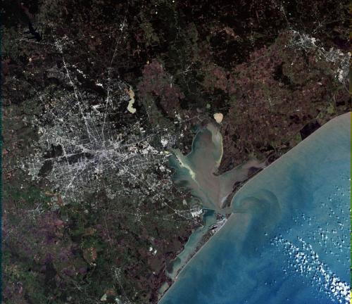
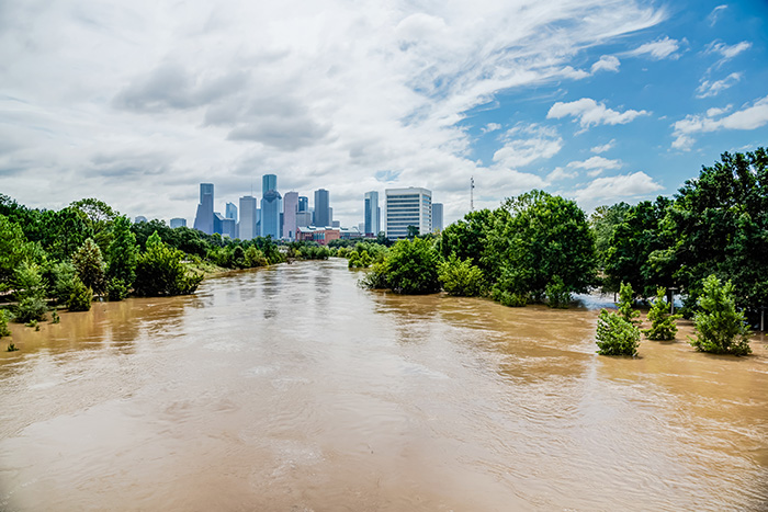
Hurricane Harvey came ashore on August 25th near Rockport, TX, with 120 mph winds devastating the small coastal town and flooding the coastal areas with a storm surge, then made another landfall at Holiday Beach as a category 3. By that time, the storm was rapidly weakening to become a tropical depression, and it also was moving very slowly towards the sprawling metropolis of Houston. The storm basically stalled over the city for a few days, and it was rain, not wind, that would become deadly. Harvey has two primary lessons for us: (1) that the warmer atmosphere of today and the future, combined with the predicted slower movement of some storms, can be devastating “rain engines” that dump biblical amounts of precipitation on coastal communities and cause life-threatening flooding; and (2) that particular cities have a great deal more vulnerability than others because of low elevation combined with poor planning. On this note, Houston is a sprawling metropolis of 6 million people that has set itself up for catastrophe.
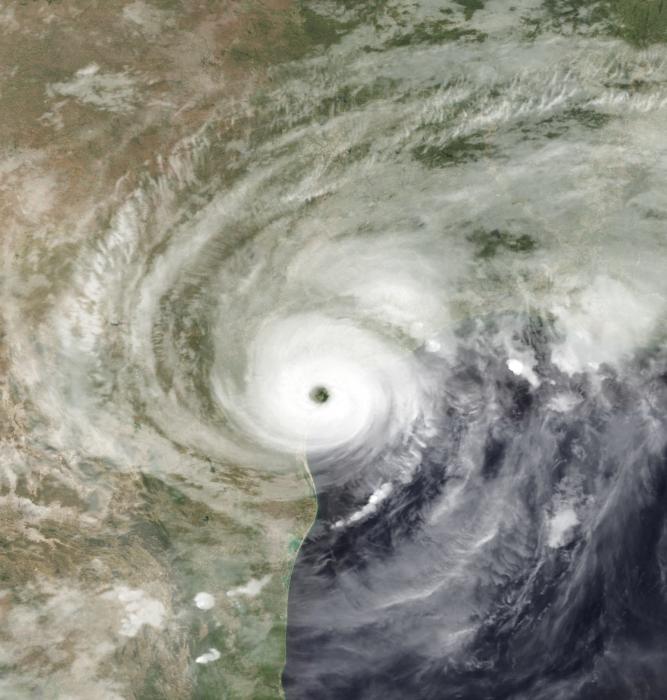
Tropical Storm Harvey was the wettest storm ever to hit the US. The Gulf of Mexico is an incredibly warm water mass, with a temperature of 30 deg C (86 deg F) during Harvey. As we learned in the last module, warm water holds more moisture than cold water and ocean warmth also fuels the energy for the storm. For every 1°C increase in temperature, the atmosphere can hold around 7 percent more water vapor. This may not sound like a lot, but think about this, hurricanes can form when waters exceed 26 deg C (79 deg F) in temperature, so the Gulf of Mexico atmosphere could hold almost 30 percent more moisture than other storms. And because under many conditions the warm atmosphere makes storms move slower, means that devastating rain engines like Harvey will become increasingly common in the future.
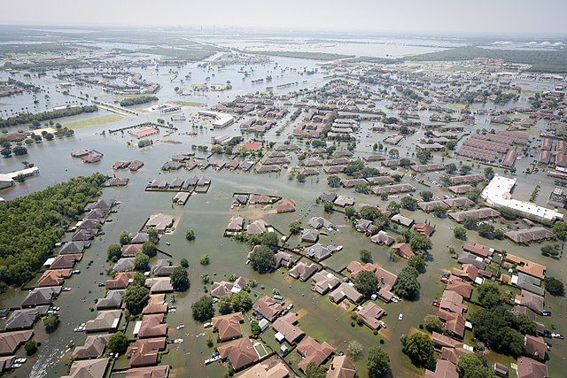
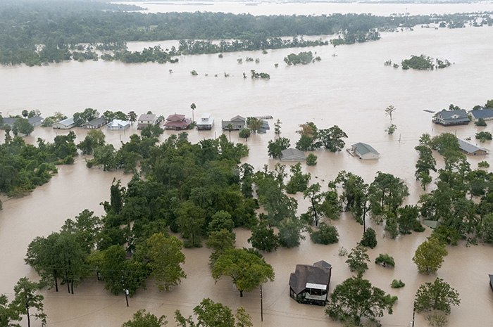
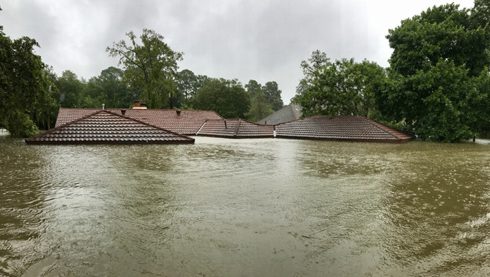
Let’s talk about the rain. The rainfall in Harvey has often been called a rain “bomb”, but the term rain bomb is generally reserved for locally intense rainfall over periods of minutes or hours at most. So for Harvey, what we saw was a nuclear rain bomb! It poured for days! Over the five-day period from August 25 to August 29, many parts of Houston received over 30 inches of rain (0.76 meters) with a maximum of 60.58 inches in Nederland, Texas. In total, the Houston region received over 24 trillion gallons of rain. That is enough water to fill every NFL and Division 1 football stadium 100 times over!
_(50).jpg)
The other ingredient for the disaster in Houston was the lack of planning and smart land use. Houston has experienced growth more rapidly than almost any US city, and it has spread outwards rather than upwards. The city now covers an area as large as Chicago, Cleveland, Detroit, and Philadelphia combined! In fact, a large part of the city is built on an ancient floodplain, the Katy Prairie, which extends 30 miles west of downtown. This prairie acts like a natural sponge for water, but is largely paved over during the rapid growth of the Houston metro area. Even outside of the prairie, urbanization clearly intensified runoff and flash flooding. In fact, planning is not a strong point of development in Houston. The city has no zoning and little regulation of any sort. It’s a pro-business, small-government boom town! You drive around town, and you might see pawn shops next to schools and factories next to churches. So the floodplain is full of housing developments and apartment complexes. To make matters worse, development was permitted inside two large reservoirs, the Barker and Addicks Reservoirs which ironically were originally purchased by the Army Corps of Engineers to protect the downtown from flooding, and many of the families living in the reservoir only found out about it AFTER Harvey. Water levels in the reservoirs were controlled by dams and flood gates, but the Corps had a delicate balancing act. They had to release water slowly down the Buffalo Spillway on the east side to prevent the dam from overtopping, which would have caused a catastrophe, but they could not release so much because that would have flooded downtown. But as it turned out, properties in the reservoir flooded; a gated development called Canyon Gate at Cinco Ranch within the Barker Reservoir with over 700 homes suffered extensive flooding. Those living within the reservoirs may have been more fortunate than those living around it. The Corps released water down the Buffalo Spillway into Buffalo Bayou without warning homeowners and flooded homes in West Houston. There was extensive damage and several fatalities. Needless to say, the Corps has endured severe criticism and lawsuits.
This sequence shows how the flooding occurred around the Barker and Addicks Reservoirs: New York Times: How One Houston Suburb Ended Up in A Reservoir
Long term, there is a discussion about building structures called a berm around what is left of wetlands in the Katy Prairie to provide flood control to development in the western part of Houston. But even then the location of the city and its elevation combined with the sheer amount of concrete and lack of flood control means that storms like Harvey are almost certain to happen again, and it will take a lot more than that to avoid catastrophe in the future. Whole neighborhoods will need to be resettled, and new construction banned in certain locations. But those types of regulations will be a tough political sell in a pro-business town. In 2008, Hurricane Ike prompted a debate that was reinvigorated after Harvey about the need for better coastal protection to prevent storm surges from flooding Houston via the Houston Ship Channel and Galveston Bay, from the Gulf. And the next massive rain soaker of a storm might be on the horizon.