Prioritize...
Upon completion of this section, you should be able to identify the first three ingredients listed for tropical cyclone formation (typical sea-surface temperatures, location at least five degrees latitude away from the equator, and a pre-existing disturbance with favorable low-level spin and convergence), as well as be able to discuss how and why these ingredients are important for tropical cyclone formation and / or maintenance. Furthermore, you should be able to identify common sources of seedling tropical disturbances that can develop into tropical cyclones.
Read...
Any chef knows that having the right ingredients is critical for cooking a delicious meal. Have you ever tried to cook something when you were missing necessary ingredients? It's pretty hard (or perhaps impossible)! The tropical atmosphere is no different: "cooking up" a tropical cyclone requires the right ingredients. So, just what ingredients are required for a tropical cyclone to form and thrive? Check out the list below:
Tropical Cyclone Ingredients
The six basic ingredients for tropical cyclone formation are:
- Sea-surface temperatures of at least 26.5 degrees Celsius or 80 degrees Fahrenheit (usually). A deep warm layer of water beneath the ocean surface (of at least 50 meters or so) can be helpful, but is not necessarily required.
- A location (usually) at least five degrees of latitude (roughly 300 nautical miles) away from the equator.
- A pre-existing disturbance (cluster of showers and thunderstorms) with favorable low-level spin and convergence in the lower half of the troposphere.
- Low values of vertical wind shear between roughly 5,000 and 38,000 feet (generally less than 10 meters per second, or 20 knots).
- A middle troposphere (roughly from about 10,000 to 20,000 feet) that is relatively moist (has moderate to high relative humidity).
- A troposphere that is neutrally stable or unstable with respect to rising moist air parcels (environmental lapse rates must not be too stable such that thunderstorm development is greatly inhibited).
In this section, we'll focus on the first three ingredients on the list.
Sea-Surface Temperatures
As we've already covered, weather records are filled with evidence that sea-surface temperatures play an integral part in the formation, development, intensification and decay of tropical cyclones. Indeed, tropical cyclones are ultimately driven by large evaporation rates, which moisten the air and fuel thunderstorms. All else being equal, evaporation rates increase with increasing sea-surface temperatures, so tropical forecasters look for sea-surface temperatures of 80 degrees Fahrenheit (26.5 degrees Celsius) or higher for tropical cyclones to form, develop, and intensify. Of course, exceptions exist (a small percentage of tropical cyclones have formed with lower sea-surface temperatures), but 26.5 degrees Celsius works well as a general guideline for the sea-surface temperatures typically needed to create sufficient evaporation rates.
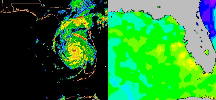
Once a tropical cyclone has formed, as long as other environmental factors are favorable, the storm may intensify if it passes over warmer patches of ocean water. Take Hurricane Charley (2004) as an example. Charley rapidly intensified from a Category 2 to a Category 4 storm as it passed over very warm water along the west coast of Florida in August, 2004 (marked by the yellow and orange shaded areas on the map of sea-surface temperatures on the right). On the flip side, strong tropical cyclones actually play a role in lowering sea-surface temperatures in the waters over which they travel. The powerful winds of strong tropical cyclones really churn up the ocean water beneath them, which causes cooler water from beneath the surface to mix to the top (a process called "upwelling").
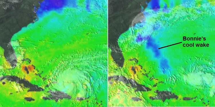
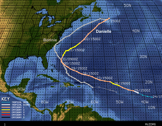
To see what I mean, check out the side-by-side images above. The image on the left shows Hurricane Bonnie and sea-surface temperatures on August 22, 1998. The image on the right (from August 28) shows the cool trail left by Bonnie (in blue) while Hurricane Danielle passed to the north of the Caribbean Islands on a northwestward track toward the Atlantic Coast. The darker blue shadings that mark Bonnie's cool wake represent sea-surface temperatures less than 80 degrees Fahrenheit (26.5 degrees Celsius). It turns out that Danielle passed right over Bonnie's cool wake between August 29th through the 31st. Bonnie's cool wake helped prevent Danielle from strengthening during this time, despite other environmental conditions that were largely favorable. A hurricane passing over another hurricane's cool wake is a relatively rare occurrence, but more commonly, a strong tropical cyclone can contribute to its own demise if it stalls or moves very slowly over shallow warm water. The upwelling of cooler water beneath the ocean surface reduces sea-surface temperatures beneath the storm, which reduces evaporation rates, stabilizes the atmosphere somewhat, and weakens thunderstorms.
Latitude
When we looked at tropical cyclone climatology, I mentioned that tropical cyclones generally don't form within about 5 degrees latitude of the equator. Why is that? The answer lies in the Coriolis Force. It's the Coriolis Force that paves the way for embryonic tropical cyclones to "spin up". Recall that the magnitude of the Coriolis Force is zero at the equator and increases with increasing latitude. That means the Coriolis Force is relatively weak throughout the tropics, and less than five degrees from the equator, it's generally too weak to impart a circulation on a developing area of low pressure.
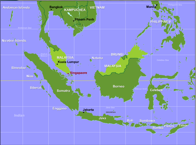
In rare circumstances, tropical cyclones have formed within 5 degrees of the equator. In these cases, the spin for the system must originate from some other source since the Coriolis Force is too weak. In perhaps the most striking example, on December 26, 2001, a tropical cyclone named Vamei formed at approximately 1.5 degrees North latitude near Singapore (on the southern tip of Malaysia). Astonishingly, Vamei intensified into a typhoon in less than 24 hours while it was less than two degrees latitude away from the equator! Vamei spun up so close to the equator that its winds howled in both hemispheres simultaneously.
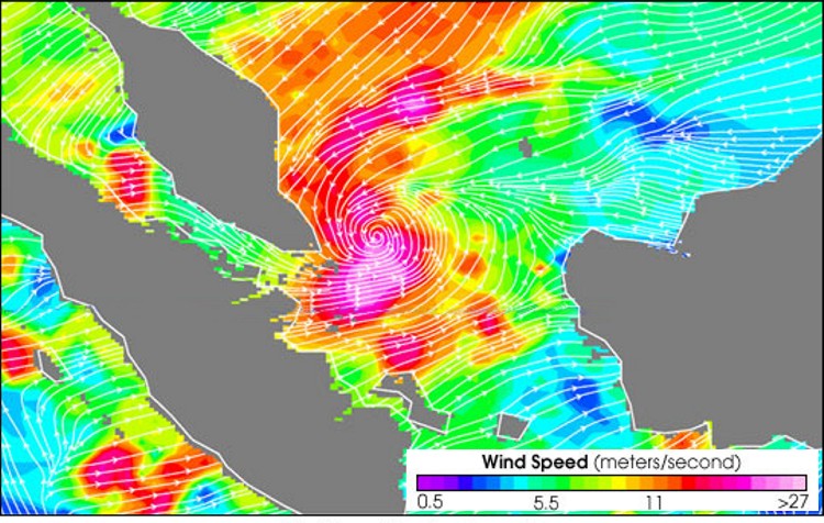
In this particular case, the lay of the land and water helped impart some spin on the air. Prior to the formation of Vamei, persistent north-northeasterly winds blew over the narrow, southern South China Sea. The funneling of the air into the South China Sea led to a strengthening of the wind. Moreover, the Malaysian Peninsula channeled the air into a counterclockwise pattern of winds, creating a background source of low-level spin (follow the arrows in the image of satellite derived winds below). This background of low-level spin, in tandem with a timely cluster of showers and thunderstorms that migrated over this region, set the stage for an unusual storm that defied all the textbooks.
The bottom line is that developing tropical cyclones require a sustained circulation, and typically that requires them to be at least 5 degrees from the equator so that the Coriolis Force can provide a sufficient contribution. Cases like Typhoon Vamei are the exception, and they get their circulation from other sources. Note that the presence of a cluster of showers and thunderstorms was a key ingredient in Vamei's development, which leads us to our next tropical-cyclone ingredient.
A Pre-Existing Disturbance
Even in areas with very warm sea-surface temperatures located suitably far from the equator, tropical cyclones have no chance to form without another crucial ingredient. Tropical cyclones simply will not form unless there is a tropical disturbance (cluster of showers and thunderstorms) that moves into an environment with favorable low-level spin. You might find it helpful to think of low-level spin and the cluster of showers and thunderstorms as the match and the fuel (respectively) that "ignite" the "heat engine" of a tropical cyclone. Keep in mind that on average, 80 to 90 tropical cyclones form each year -- a number that pales in comparison to the annual mob of extratropical cyclones that parade across the middle and high latitudes. So, although tropical cyclones can grow to be quite fierce, they can also be fragile in the sense that any of the ingredients discussed in this lesson can be missing or added in a way that's unfavorable for formation. And, lacking a seedling disturbance with favorable low-level spin is a non-starter for the entire process.
So, what are the more common sources of tropical disturbances with favorable spin that help incite tropical cyclone formation? In short, different tropical basins have different sources of favorable low-level spin, but in general, we can identify several common sources. Here, I'm going to focus on two:
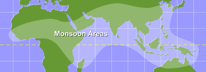
- monsoon troughs -- particularly in the western Pacific, eastern Pacific, western Caribbean, Indian Ocean, and south Pacific
- easterly waves (clusters of showers and thunderstorms with a low-level circulation originating over northern Africa) -- primarily in the Atlantic and eastern Pacific in the Northern Hemisphere
Worldwide, the most prominent source of tropical disturbances with favorable low-level spin for tropical cyclones are monsoon troughs that form in the various monsoonal regions. In the western Pacific, for example, roughly 70-80 percent of tropical cyclones form out of disturbances originating in a monsoon trough. So, what makes monsoon troughs such hot spots for activity? As you know, surface troughs of low pressure are regions of low-level convergence (favorable for thunderstorm formation), but monsoon troughs are also naturally regions of favorable low-level spin, as the schematic below shows.
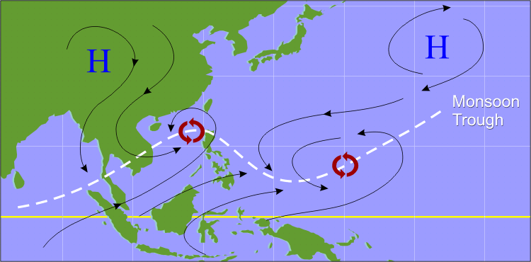
Because the monsoon trough marks a region where the trade winds and cross-equatorial westerlies come together, it's naturally a region of low-level convergence and favorable spin. The enhanced pre-existing low-level spin helps initially disorganized disturbances to develop well-defined low-level circulations. Besides the northwest Pacific, this mechanism is responsible for providing the seedling disturbances for most tropical cyclones in the Indian Ocean and south Pacific basins, but it can also be a factor occasionally in the eastern Pacific and western Caribbean.
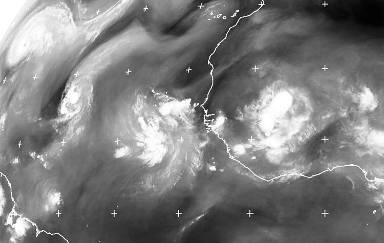
In the Atlantic and eastern Pacific, easterly waves (sometimes generically called "tropical waves") are common sources of seedling disturbances. To demonstrate how important easterly waves are in acting as seedling disturbances for tropical cyclones, consider these stats: Easterly waves initiate approximately 60 percent of the Atlantic tropical storms and minor hurricanes (Categories 1 and 2 on the Saffir-Simpson Scale), and nearly 85 percent of all the major Atlantic hurricanes (Category 3 or higher). Easterly waves are fairly common from June through October -- one exits the west coast of Africa about once every three or four days, so most easterly waves don't go on to become hurricanes. As an example, this water vapor image from 00Z on August 27, 2010 shows a parade of easterly waves on their westward trek across the Atlantic. At the upper-left of the image, you can see Hurricane Danielle, which had formed from an easterly wave.
Other sources for clusters of thunderstorms with favorable low-level spin exist, too. For example, cold fronts that penetrate into the fringes of the tropics (in the Gulf of Mexico, for example), often become stationary and can linger for extended periods of time. As you know, fronts are regions of low-level convergence and directional wind shifts, which can generate low-level spin. If thunderstorms drift over these areas (or develop over them), they can eventually seed the development of a tropical cyclone; however, tropical cyclones that develop from these fronts are often not completely tropical in nature initially (they're initially classified as "subtropical"). Regardless of the source of the disturbance, to assess whether a tropical cyclone may form and thrive, we have to examine conditions in the middle and upper troposphere to see if the environment is favorable for sustaining thunderstorms. We'll start doing that in the next section as we explore the rest of our ingredient list. Read on.